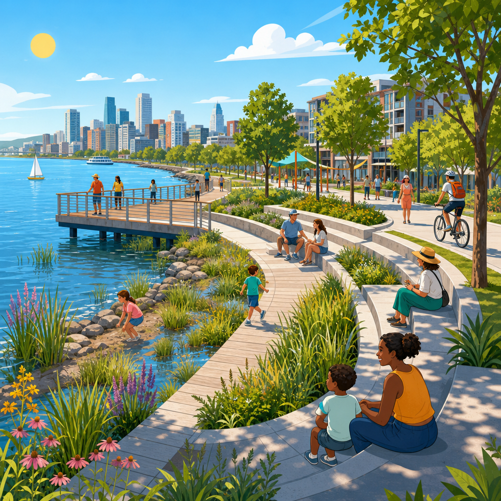
Waterfront public space design for flooding, heat, and access has become a defining challenge for cities that want lively parks, safe streets, and equitable shorelines in an era of rising water, hotter summers, and aging infrastructure. In practice, the term means planning, engineering, and managing promenades, piers, riverwalks, beaches, plazas, and ecological edges so they remain useful during everyday conditions and resilient during storms, heat waves, and high tides. Flooding refers not only to catastrophic storm surge, but also to tidal inundation, riverine overflow, groundwater rise, and intense rainfall that overwhelms drainage systems. Heat includes both air temperature and radiant heat from pavement, walls, and sparse tree canopy. Access means more than an ADA-compliant ramp; it includes safe arrival, continuous movement, comfort, visibility, affordability, and year-round use for children, older adults, workers, and visitors. Because waterfronts concentrate risk and opportunity in the same places, good design must solve several problems at once.
I have worked on waterfront planning processes where a single boardwalk needed to function as a public amenity, emergency route, habitat buffer, utility corridor, and flood edge. Those projects taught a consistent lesson: the best waterfront public space design starts with systems thinking. A bench location can influence shade use, pedestrian flow, and evacuation. A planted berm can reduce wave energy, create habitat, block views, or improve them depending on grade and species. Material choices shape maintenance budgets for decades. Cities from Rotterdam to New York, Copenhagen to Singapore, have shown that attractive waterfronts do not need to choose between beauty and resilience. They can absorb water, reduce heat stress, and improve public access simultaneously, but only when designers coordinate landscape architecture, civil engineering, transportation, ecology, and operations from the beginning. This hub article explains the core principles, tradeoffs, and design moves that make that possible.
Start With Risk Mapping and Daily Use Patterns
The first step in waterfront public space design is understanding what water, weather, and people actually do on the site. Designers should map base flood elevation, future sea level rise scenarios, storm surge pathways, outfall locations, groundwater conditions, erosion zones, wind exposure, and extreme heat hotspots. Just as important, they should map desire lines, transit stops, school routes, fishing areas, informal seating spots, and where people cluster during lunch, sunset, or special events. A technically elegant flood edge can fail if it blocks common pedestrian movement or creates isolated areas after dark. I have seen projects improve by pairing hydraulic modeling with simple observational studies: counting how many people pause, cross, sit, cycle, and queue at different times. The result is a design rooted in both hazard data and public behavior.
Risk mapping should distinguish among frequent, moderate, and extreme events. Designing only for the hundred-year flood can leave a waterfront unusable during monthly nuisance flooding, while designing only for daily comfort can leave public assets exposed during storms. Good hub-level planning typically creates layered performance targets: keep paths open during light rain, protect key utilities during king tides, allow controlled overtopping in designated zones during major storms, and provide clear recovery procedures after severe events. Thermal mapping is equally important. Surface temperature readings often reveal dramatic differences between dark asphalt and shaded paving, especially in low-breeze waterfront areas where reflected heat from buildings increases discomfort. This evidence supports decisions on canopy coverage, surface albedo, seating orientation, and misting or water-play features.
Design Flood Resilience as a Layered Public Realm Strategy
Flood resilience works best when it is distributed across the waterfront rather than concentrated in a single wall or barrier. A layered strategy can include offshore attenuation, restored wetlands, sloped planted edges, deployable barriers at building entries, raised promenades, sacrificial lower terraces, and drainage systems sized for cloudbursts. The key is controlled performance. Instead of assuming the site must stay completely dry in every event, effective waterfront public space design determines where water can safely go, how quickly it can drain, what can get wet without major damage, and how the space reopens. This approach often costs less over the lifecycle than trying to harden every square foot equally.
Elevational zoning is one of the most reliable tools. Lower levels can host overlooks, launch points, or flexible plazas built with durable materials, while upper levels carry essential circulation, lighting, and utilities. Brooklyn Bridge Park uses changes in grade, resilient planting, and robust detailing to support both public use and flood tolerance. Rotterdam’s water plazas offer another lesson: public spaces can hold excess water temporarily while remaining attractive and legible in dry weather. Along riverfronts, terraced edges can slow flow velocity and create varied habitats, but terraces must be detailed for scour, debris impact, and safe egress. Utility design matters too. Electrical rooms, irrigation controls, and communications equipment should be elevated, sealed, or placed outside flood-prone zones. If not, a visually successful park can still experience long closures after a moderate event.
Reduce Heat With Shade, Surface Choice, and Microclimate Design
Heat resilience is not a cosmetic add-on. On exposed waterfronts, especially those with wide paved esplanades, summer surface temperatures can become dangerous even when air temperatures seem manageable. The most effective response is layered shade: large-canopy trees where soil volume permits, shade structures over seating and play areas, covered transit waiting points, and building edges that reduce afternoon solar exposure. In my experience, many projects underestimate how much shade people need between noon and 5 p.m. A few decorative trees will not make a long promenade comfortable. Targets should focus on shaded routes as well as shaded destinations, so people can move across the site without prolonged exposure.
Materials strongly influence heat. Light-colored paving generally absorbs less solar radiation than dark asphalt, but reflectivity must be balanced against glare, especially near water. Permeable surfaces can reduce runoff and support cooler conditions, though they need careful subbase design in tidal or saline environments. Trees need adequate uncompacted soil, irrigation establishment, and species selection based on salt tolerance, flood tolerance, and wind resistance. London plane tree may succeed in some urban settings, while bald cypress, black gum, or honey locust may be better choices in others depending on water regime and maintenance capacity. Microclimate design also includes breeze management. Waterfronts often have excellent air movement, but walls, kiosks, and dense planting can block beneficial winds if poorly placed. Shade, evapotranspiration, and ventilation should be designed together.
Make Access Continuous, Inclusive, and Easy to Understand
Access is the measure the public notices first. If reaching the waterfront is confusing, steep, fragmented, or perceived as unsafe, even a technically advanced project will underperform. Continuous access begins before the shoreline. Good design aligns entrances with surrounding street grids, transit stops, bike routes, and neighborhood desire lines. It minimizes dead ends and creates a clear sequence from city to water. Grades should be comfortable, crossings protected, and wayfinding intuitive. Accessible design is not just a legal baseline under standards such as the Americans with Disabilities Act; it is a quality benchmark for everyone. Wide paths, frequent seating with backs and arms, tactile cues, handrails where needed, and clear sightlines improve comfort for families, older adults, and people with temporary injuries as much as for wheelchair users.
Equitable access also depends on programming and operations. A waterfront lined with private concessions and event fencing can feel exclusionary even if physically open. Public restrooms, drinking water, shade, free seating, and unprogrammed space are basic ingredients of civic access. Safe nighttime use requires lighting that supports visibility without causing excessive glare or ecological harm. Connections across rail lines, highways, and industrial remnants are often the hardest part of waterfront public space design, yet they frequently determine whether residents from nearby neighborhoods actually use the space. Cities such as Chicago and Toronto have improved waterfront reach by combining trail continuity, underpass design, signage, and coordinated transit investment. Access should be measured by travel time, comfort, safety, and social welcome, not simply by the presence of an entrance gate.
Balance Ecology, Recreation, and Maintenance From Day One
The strongest waterfronts are multifunctional landscapes. They provide habitat, absorb runoff, host recreation, support events, and remain maintainable with real municipal budgets. Problems emerge when ecological goals and public use are treated as separate agendas. A planted shoreline may improve habitat but fail if trampling is unavoidable and no durable edge is provided. Conversely, a heavily programmed hardscape may boost event revenue while worsening runoff, heat, and habitat fragmentation. The right balance depends on wave climate, contamination history, bank stability, public demand, and stewardship capacity. Nature-based features should be selected for local performance, not trend value. Living shorelines, oyster reefs, salt marsh benches, and coir systems can be highly effective in low-energy environments, but they are not universal substitutes for revetments or bulkheads.
Maintenance planning must shape design early. I have seen elegant details fail because replacement parts were specialized, planting beds were inaccessible to crews, or drainage inlets clogged with litter after every storm. Designers should specify durable railings, corrosion-resistant fasteners, cleanable joints, and planting palettes that match available horticultural care. The table below summarizes core decisions and their practical implications.
| Design issue | Preferred response | Why it works |
|---|---|---|
| Frequent nuisance flooding | Raised primary path with lower floodable terrace | Keeps circulation open while allowing controlled inundation |
| Extreme summer heat | Continuous shade network plus high-albedo paving | Reduces radiant load and improves route comfort |
| Barrier to neighborhood entry | Aligned crossings, ramps, and visible gateways | Makes arrival intuitive and inclusive |
| Habitat loss at hardened edge | Terraced planting or living shoreline where feasible | Adds ecological function without eliminating access |
| High maintenance burden | Robust materials and simple replaceable components | Lowers downtime and lifecycle cost |
Use Governance, Phasing, and Metrics to Keep Performance Real
Even the best design drawings are only a starting point. Waterfront public space design succeeds long term when governance, funding, and performance measurement are clear. Someone must own inspections after storms, sediment removal, tree care, lighting repairs, restroom operations, and emergency closures. Public agencies, conservancies, port authorities, and private partners often share these responsibilities, but unclear roles create delayed recovery and visible decline. I recommend writing an operations matrix during design development, not after construction. It should identify every major asset, expected maintenance frequency, replacement cycle, and responsible party. That document often reveals whether a seemingly affordable concept is actually viable.
Phasing is equally important because many cities cannot fund full shoreline transformation at once. A strong phased plan protects the most vulnerable assets first, establishes continuous public access early, and avoids temporary work that blocks future resilience improvements. Metrics should be practical and public facing: percentage of shaded route miles, hours to reopen after a minor flood, number of accessible entries, canopy survival rate after three years, reduction in runoff volume, and visitation by nearby residents. Post-occupancy evaluation is essential. Count users, monitor temperatures, survey comfort, and compare flood performance against modeled assumptions. When cities publish those findings, later projects improve faster. Waterfronts are long-life civic assets. Their design should be judged not only by opening-day photographs, but by how safely, comfortably, and equitably they serve people through decades of change.
Waterfront public space design for flooding, heat, and access is ultimately about making the shoreline both resilient and genuinely public. The most successful projects begin with risk mapping, then translate that evidence into layered flood strategies, cooler microclimates, and continuous inclusive access. They treat ecology, recreation, and maintenance as one design problem rather than competing priorities. They also recognize that operations, funding, and performance metrics matter as much as planting plans and paving details. When these pieces align, waterfronts can absorb water, reduce heat stress, support biodiversity, and invite daily use from a broad public.
For cities working under the broader goal of sustainable urban development, this hub topic deserves sustained attention because waterfronts sit at the intersection of climate adaptation, public health, mobility, and social equity. A resilient shoreline park is not just an amenity; it is infrastructure, habitat, cooling space, and civic commons at the same time. If you are planning a new waterfront or upgrading an existing one, start by auditing flood exposure, heat conditions, and access barriers together. That integrated assessment will reveal the design moves with the highest public value and the strongest long-term return.
Frequently Asked Questions
What does waterfront public space design for flooding, heat, and access actually involve?
Waterfront public space design for flooding, heat, and access is the practice of shaping parks, promenades, piers, plazas, beaches, riverwalks, and shoreline streets so they work well in everyday conditions and remain functional during extreme weather. It is not just about stopping floodwater with a wall or adding a few trees for shade. It combines landscape architecture, civil engineering, ecology, transportation planning, public health, and operations management to create places that can handle rising water levels, heavier rainfall, hotter temperatures, and changing patterns of use.
In practical terms, this work often includes setting grades carefully, selecting durable materials, using flood-tolerant planting, creating shaded routes, improving drainage, planning flexible seating and gathering areas, and making sure routes are accessible to people of all ages and abilities. It also means deciding which areas should stay dry most of the time, which can safely flood and recover, and how people will move through the site before, during, and after an event. A successful waterfront space is not only resilient in an engineering sense, but also welcoming, legible, safe, and easy to maintain over time.
Because waterfronts are dynamic environments, the best designs do not treat flooding, heat, and access as separate issues. For example, a raised path can improve accessibility and maintain circulation during nuisance flooding, while adjacent planted areas can store stormwater and reduce surface temperatures. Similarly, a shaded plaza can improve comfort during heat waves, but its structure and materials should also be able to withstand salt exposure, periodic inundation, and strong winds. In that sense, good waterfront design is about balancing protection, comfort, equity, ecology, and long-term adaptability rather than solving one problem in isolation.
How do designers plan waterfront spaces that can handle flooding without becoming unusable?
Designers begin by recognizing that flood risk along a waterfront comes from multiple sources, not only major storms. High tides, seasonal water level changes, wave action, storm surge, sea level rise, river flooding, and intense rainfall can all affect how a public space performs. That is why resilient waterfront design usually relies on layered strategies rather than a single defensive measure. Some parts of a site may be elevated, some designed to absorb or temporarily store water, and some intended to flood safely and reopen quickly after the water recedes.
Common approaches include raising critical pathways, locating electrical and mechanical systems above projected flood levels, using permeable surfaces where appropriate, restoring wetlands or living shorelines, building terraces that dissipate wave energy, and creating edge conditions that can tolerate periodic inundation. Designers also pay close attention to how water enters and exits a site. If water can get in but not drain out, even a well-built park can remain closed or damaged for long periods. Grading, outfalls, backflow prevention, soil design, and maintenance access are all essential parts of the solution.
Usability depends on designing for recovery as much as for resistance. Materials should be selected for durability, washdown, and ease of replacement. Site furnishings may need to be anchored, movable, or sacrificial depending on the exposure level. Plant communities should be chosen based on salinity, saturation, wind, and heat tolerance. Clear wayfinding and emergency signage help users understand what areas may close during certain conditions. When done well, flood-resilient design does not make the waterfront feel defensive or off-limits. Instead, it creates public spaces that remain lively in normal weather, fail more gracefully during events, and return to service faster afterward.
Why is heat mitigation such an important part of waterfront public space design?
Although waterfronts are often assumed to be cooler because they are near water, many public shoreline spaces become dangerously hot during summer afternoons. Large paved surfaces, limited tree canopy, reflected glare from water, little shelter from sun, and long exposed walking distances can all drive heat stress. In some locations, humidity and reduced nighttime cooling make the problem even worse. For that reason, heat mitigation is not a cosmetic upgrade. It is a core public health and comfort issue that affects whether people can safely use the space, how long they stay, and who feels welcome there.
Effective heat-responsive design usually combines shade, materials, planting, ventilation, and access to cooling features. Trees are often the most valuable long-term investment because they provide shade, improve comfort, reduce surface temperatures, and enhance the character of the space. Shade structures, canopies, arcades, and pavilions can supplement trees in areas where roots, salt spray, utilities, or program demands make planting difficult. Designers also look at pavement color and thermal performance, provide seating in shaded locations, preserve airflow where possible, and consider drinking fountains, misting features, or indoor cooling refuges nearby.
Importantly, heat mitigation should be planned with equity in mind. Older adults, children, outdoor workers, people with disabilities, and residents without access to private cooling are often most affected by extreme heat. A waterfront that looks attractive but lacks shade, rest areas, and accessible amenities may exclude the very people public space is meant to serve. Good design treats thermal comfort as part of universal access. That means creating continuous shaded routes, distributing cooling opportunities throughout the site, and making sure comfort is available not just in premium areas but across the entire public realm.
How can waterfront public spaces remain accessible and equitable as climate risks increase?
Accessibility and equity are central to waterfront design because climate adaptation projects can unintentionally create barriers if they focus only on infrastructure. Raising a promenade, adding protective edges, or reworking circulation can improve resilience, but if these changes produce steep routes, long detours, confusing entrances, or uneven surfaces, they may make the space harder to use for people with mobility, sensory, or cognitive disabilities. Equitable design asks a broader question: not just whether people can technically enter the waterfront, but whether they can reach it comfortably, move through it safely, find places to rest, and participate fully in its social and recreational life.
That means providing step-free routes, generous ramp systems, tactile wayfinding where needed, stable walking surfaces, handrails in key locations, seating at regular intervals, accessible overlooks, clear signage, and public amenities such as restrooms, drinking water, lighting, and transit connections. Designers also need to think about first-mile and last-mile access. A beautiful shoreline park is not truly public if nearby streets are unsafe to cross, bus stops are distant, bike access is poor, or entrances are hidden behind private development. Access must extend from surrounding neighborhoods all the way to the water’s edge.
Equity also involves programming, governance, and community engagement. Waterfront improvements can raise property values and change who feels entitled to use the space. Inclusive planning processes, multilingual outreach, affordable concessions, culturally relevant programming, and attention to displacement risks all matter. During climate events, accessible emergency communication and clear closure and reopening procedures are equally important. The strongest projects are those that treat resilience as a public good, ensuring that the benefits of cooling, safety, mobility, and shoreline enjoyment are shared broadly rather than concentrated in a few highly visible areas.
What are the most important features of a successful climate-resilient waterfront public space?
A successful climate-resilient waterfront public space usually has a combination of physical durability, environmental performance, user comfort, and operational readiness. Physically, it is designed to account for present and future flood conditions, using layered protection, thoughtful grading, robust materials, and infrastructure that can survive or recover from inundation. Environmentally, it supports habitat, improves stormwater management, and works with shoreline processes where possible instead of relying entirely on hard-edge solutions. From the user perspective, it feels safe, shaded, legible, and inviting, with continuous access, flexible programming, and amenities that encourage daily use.
Another essential feature is adaptability. Climate conditions, maintenance budgets, community needs, and regulatory requirements all change over time. A well-designed waterfront is not frozen in a single moment. It allows for phased upgrades, future elevation changes, replacement of vulnerable elements, and adjustments to planting, furniture, or operations as conditions evolve. Designers and city agencies increasingly value spaces that can accommodate occasional flooding without catastrophic damage and that can be modified as new climate projections emerge.
Finally, long-term success depends on management, not just design. Even the best plan can underperform without maintenance, inspections, emergency protocols, and clear responsibility for upkeep. Trees need care, drains need cleaning, surfaces need repair, and public communication needs to be consistent. Monitoring how the space performs during storms, heat waves, and busy seasonal periods helps cities refine future improvements. In the end, the most successful waterfront public spaces are those that continue to deliver everyday value—recreation, mobility, cooling, ecology, and civic identity—while being honest about climate risk and prepared to live with water rather than simply resisting it.