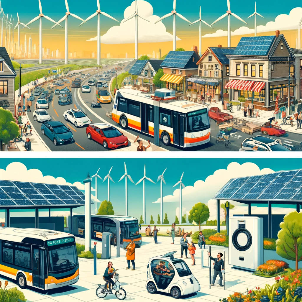
Tree canopy equity is the practice of measuring whether all residents of a city receive fair access to the cooling, health, and environmental benefits provided by trees. In urban planning, tree canopy usually means the layer of leaves, branches, and stems that covers the ground when viewed from above, while shade access refers to the real, lived ability of people to find cooler outdoor spaces where trees reduce heat exposure. This topic matters because heat risk, air pollution, flood damage, and public health burdens are not distributed evenly across neighborhoods. In many cities I have worked with, the same blocks that lack tree cover also have more pavement, fewer parks, older housing, and lower household incomes. That overlap makes canopy equity a core issue in sustainable urban development rather than a cosmetic landscaping concern.
Cities measure shade access because tree planting alone does not guarantee fair outcomes. A neighborhood may show moderate canopy on a map yet still leave bus stops, school routes, playgrounds, and senior housing exposed during the hottest hours of the day. Reliable measurement helps agencies answer practical questions: Which streets have the highest heat burden? Which residents face the greatest exposure? Where should maintenance budgets go first? How much canopy is enough to reduce surface temperature, improve walkability, and support stormwater goals? The strongest urban forestry programs connect canopy data with land use, public health, transportation, housing, and climate resilience planning. When cities do that well, they move from counting trees to managing environmental benefit where it is needed most.
What tree canopy equity means in practice
Tree canopy equity combines two ideas: distribution and access. Distribution asks whether tree cover is spread fairly across neighborhoods. Access asks whether people can actually use the shade where they live, walk, wait, play, and work. That distinction is essential. A golf course, cemetery, or private campus can increase canopy statistics without improving daily shade access for nearby residents. Likewise, riparian woodlands at a city edge may support biodiversity and flood control but do little for a dense district with dangerous summer sidewalk temperatures.
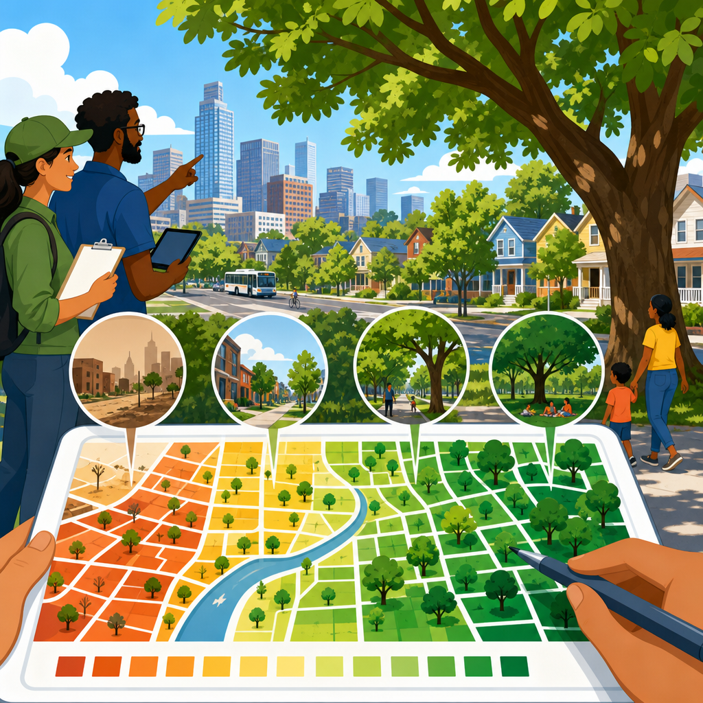
In practice, most city programs start with urban tree canopy assessments created from aerial imagery, LiDAR, or high-resolution land cover classification. Analysts measure total canopy percentage by parcel, block group, neighborhood, council district, or census tract. Then they compare those patterns with demographic indicators such as income, race, age, health vulnerability, rent burden, language isolation, and car ownership. I have found that the clearest equity analyses also include urban heat island metrics, because low canopy is often most harmful where dark surfaces, little wind, and limited green space raise daytime and nighttime temperatures.
The point is not simply to equalize canopy percentages everywhere. Downtown commercial blocks, industrial corridors, and compact historic neighborhoods have different physical constraints than suburban streets. Equity means giving priority to places where additional shade would produce the greatest public benefit and correcting long-standing underinvestment. Cities that understand this avoid simplistic targets and instead adopt neighborhood-specific goals tied to heat exposure, pedestrian demand, and available planting space.
How cities measure canopy and shade access
The baseline metric is canopy cover percentage, usually derived from satellite imagery or airborne surveys. LiDAR is especially useful because it captures tree height and structure, helping analysts distinguish mature canopy from grass, shrubs, or building shadows. Many cities combine this with parcel data, sidewalk inventories, right-of-way widths, and impervious surface maps. The result is a canopy assessment that shows existing cover, possible planting areas, and land ownership patterns. American Forests has helped popularize this approach through Tree Equity Score, while tools from Esri, i-Tree, and local GIS teams support city-specific analysis.
Shade access measurement goes further than canopy cover. It often includes walking routes to schools, transit stops, parks, libraries, clinics, and commercial streets. Some departments model shade at different times of day using sun angle, tree height, crown spread, and building geometry. Others conduct field audits to verify whether a mapped tree actually shades a bench, crossing, or play area. Surface temperature data from Landsat or local thermal flights can reveal where lack of shade contributes to dangerous heat. Public works teams also review maintenance records because dead, declining, or poorly pruned trees can reduce actual shade even when maps still show canopy.
| Metric | What it measures | Why cities use it |
|---|---|---|
| Canopy cover percentage | Share of land shaded by tree crowns from above | Creates a citywide baseline and allows neighborhood comparison |
| Potential planting area | Plantable space on streets, yards, campuses, and other sites | Shows where new canopy can realistically be added |
| Shade on priority routes | Tree shade along sidewalks, school paths, and transit access | Connects canopy to daily human exposure and walkability |
| Heat vulnerability index | Combined social and environmental heat risk factors | Targets investment where shade can reduce health harm most |
| Tree condition and survival | Health, maintenance needs, and mortality after planting | Prevents misleading counts and protects long-term benefits |
No single metric is enough. A neighborhood with room to plant may still lack water access, supportive property owners, or species suitable for future climate conditions. A corridor with good canopy percentage may offer poor pedestrian shade if trees sit behind walls or in parking lot islands. For that reason, leading cities build dashboards that layer canopy, heat, health, and infrastructure data together rather than relying on one number.
Why equity gaps appear across neighborhoods
Canopy inequity is usually the result of historic land use and policy choices, not random growth patterns. Redlining, disinvestment, urban renewal, highway construction, industrial zoning, and uneven code enforcement all shaped which neighborhoods received parks, street trees, and long-term landscape maintenance. In many North American cities, formerly redlined areas still have less canopy and higher summer heat than wealthier areas nearby. Studies have repeatedly shown temperature differences of several degrees Fahrenheit between neighborhoods, with some block-level gaps even larger during heat waves.
Physical form also matters. Dense blocks with narrow sidewalks, overhead utilities, curb cuts, compacted soils, and heavy traffic are harder and more expensive to plant. Renters may have little control over yard trees. Commercial districts may prioritize signage, loading, or visibility over canopy. New development can remove mature trees faster than replacement rules restore them, because a sapling does not equal the cooling effect of a fifty-year-old tree. That is why preservation is often more cost-effective than replacement, especially in neighborhoods already short on shade.
Maintenance inequity is another overlooked driver. Trees need watering, pruning, pest management, root protection, and inspection. When cities rely heavily on adjacent property owners, lower-income areas often receive less consistent care. I have seen planting campaigns produce impressive headlines but weak results because survival rates were not tracked for three summers. Equity is not achieved by planting counts; it is achieved by sustained canopy where people need relief.
Using canopy data to set policy and investment priorities
Once cities identify inequities, the next step is turning maps into policy. A strong canopy equity strategy usually sets citywide goals, neighborhood targets, and corridor-level actions. For example, a city may commit to increasing canopy from 22 percent to 30 percent overall, while setting higher priority for census tracts with low shade, high heat vulnerability, and limited park access. This allows capital budgets, grant programs, and maintenance crews to work from a common framework.
Policy tools vary by land ownership. On public land, transportation departments can redesign streets with larger tree pits, structural soil, permeable surfaces, and protected rooting zones. Parks departments can add groves around playgrounds and athletic edges where users need midday relief. School districts can convert asphalt-heavy yards into shaded outdoor learning spaces. On private land, cities may use development review, tree preservation ordinances, parking lot shading standards, stormwater credits, utility rebates, or neighborhood planting incentives. The best programs align these tools so trees are not treated as an optional amenity.
Budgeting should reflect lifecycle costs. Planting a street tree is only the beginning. Establishment watering, inspection, mulch renewal, formative pruning, and replacement funding determine whether canopy gains persist. Tools such as i-Tree Eco and i-Tree Streets can estimate benefits from energy savings, avoided runoff, air pollution removal, and carbon storage, but decision makers should use those figures carefully. The strongest business case often combines avoided heat illness, safer walking conditions, stronger commercial corridors, and resilience benefits that standard accounting misses.
What effective canopy equity programs look like
Effective programs share several traits. First, they protect mature trees aggressively. Large, healthy trees provide exponentially more shade and cooling than young trees, and replacing them can take decades. Second, they plant where people experience heat directly: bus stops, school entrances, senior centers, public housing, commercial sidewalks, and routes to parks. Third, they match species to site conditions, accounting for soil volume, drought tolerance, pest pressure, overhead wires, and projected climate change. A diverse urban forest is more resilient than one dominated by a few species.
Community engagement is also operational, not symbolic. Residents often know where puddling kills roots, where trucks strike branches, which corners feel unsafe in summer, and which landlords will not water new trees. Cities that listen early avoid costly mistakes. In my experience, the most successful outreach asks residents to rank locations and maintenance concerns, then reports back on what was funded and why. That builds trust and improves survival.
Finally, effective programs measure outcomes over time. They track canopy change, survival rates, shade on priority routes, complaints, maintenance backlogs, and heat exposure near completed projects. They also acknowledge tradeoffs. Trees can conflict with solar access, underground utilities, allergy concerns, storefront visibility, or sidewalk repair needs. Good programs resolve those conflicts through design rather than abandoning canopy goals.
Challenges, limits, and what to watch next
Measuring shade access is improving, but the field still has limits. Remote sensing may overstate usable shade, especially where canopies sit over fenced land or road medians. Census geography can hide street-by-street disparities. Heat data from satellites may miss nighttime conditions felt by residents indoors. Climate change complicates species selection, increasing drought stress, pest outbreaks, and storm damage. Cities also face staffing shortages in arboriculture and GIS, making it hard to keep inventories current.
Even with those limits, canopy equity remains one of the clearest ways to link climate adaptation with neighborhood-level quality of life. The evidence is strong: trees lower surface and air temperatures, improve comfort, intercept rainfall, and support healthier streets when they are placed and maintained well. For a sustainable urban development strategy, the central lesson is simple. Measure more than total canopy, focus on real shade access, protect mature trees, and invest first where heat burden is highest. If you are building or updating a city climate, parks, housing, or transportation plan, make canopy equity a core performance measure and use it to guide every street and neighborhood decision.
Frequently Asked Questions
What does tree canopy equity mean in a city planning context?
Tree canopy equity refers to whether the benefits of urban trees are shared fairly across all neighborhoods, income levels, age groups, and communities. In city planning, tree canopy is usually measured as the layer of leaves, branches, and stems that covers land when viewed from above, often through aerial imagery or satellite analysis. Equity adds a critical layer to that measurement. It asks not only how many trees exist, but who actually benefits from them, where they are located, and whether residents in hotter or more vulnerable areas have meaningful access to shade and cooling.
This distinction matters because a city can report an impressive overall canopy percentage while still leaving many neighborhoods with very little relief from heat. For example, wealthier areas may have mature trees lining streets and parks, while lower-income communities may have fewer trees, more pavement, less private yard space, and greater exposure to dangerous summer temperatures. Tree canopy equity helps planners identify those imbalances and prioritize investments where they are needed most.
In practice, the concept connects environmental data with public health, infrastructure, and social justice. Trees can lower surface and air temperatures, improve air quality, reduce stormwater runoff, and make outdoor spaces more comfortable and usable. When cities study canopy equity, they are trying to understand whether all residents have a fair chance to receive those cooling, health, and environmental benefits rather than allowing them to be concentrated in only a few areas.
How do cities measure shade access, and how is it different from measuring tree canopy?
Measuring tree canopy and measuring shade access are related, but they are not exactly the same. Tree canopy is typically a land-cover statistic. Cities use aerial photography, LiDAR, satellite data, and geographic information systems to estimate how much of the ground is covered by tree crowns when viewed from above. This gives planners a broad picture of where trees exist and how canopy is distributed across neighborhoods.
Shade access is more practical and human-centered. It focuses on whether people can actually find cooler outdoor spaces during hot weather in the places where they live, walk, wait, play, and travel. A neighborhood may technically have trees, but if those trees are clustered in a fenced property, an industrial edge, or a steep area that residents do not use, actual shade access may still be poor. By contrast, a smaller number of strategically placed street trees near bus stops, sidewalks, schools, playgrounds, and apartment buildings may provide a much greater day-to-day benefit.
To measure shade access, cities often combine canopy maps with temperature data, pedestrian network analysis, park access information, land use records, and demographic data. Some also model how shade shifts at different times of day and seasons. They may ask questions such as how much shade covers sidewalks during extreme heat, how far residents must walk to reach a shaded park, or whether public gathering areas have tree cover during peak afternoon temperatures. This approach produces a more realistic picture of lived experience and helps cities move beyond simple canopy totals toward equitable, health-focused planning.
Why is tree canopy equity important for public health and climate resilience?
Tree canopy equity is important because the absence of shade is not just a comfort issue; it is a safety and health issue. In many cities, neighborhoods with low tree cover experience significantly higher daytime and nighttime temperatures due to the urban heat island effect. Pavement, rooftops, parking lots, and other hard surfaces absorb and radiate heat, making outdoor environments more dangerous during heat waves. Residents in these areas may face higher risks of heat exhaustion, heat stroke, dehydration, and worsening chronic conditions such as cardiovascular and respiratory disease.
Trees help reduce these risks by cooling surrounding areas through shade and evapotranspiration. They can lower surface temperatures, improve walkability, and make outdoor spaces more usable for children, older adults, and workers who spend time outside. Trees also contribute to cleaner air by filtering some pollutants and can help manage stormwater by slowing runoff and reducing pressure on drainage systems during heavy rain. In this way, tree canopy equity supports both immediate public health and long-term climate resilience.
The equity dimension is especially important because heat and environmental burdens are not distributed evenly. Neighborhoods with fewer trees often overlap with places that have higher rates of poverty, less access to healthcare, more rental housing, greater dependence on walking or transit, and a history of underinvestment. These communities may also have fewer cooling resources indoors and outdoors. By measuring canopy equity, cities can direct planting, maintenance, and infrastructure improvements to the residents who face the greatest heat exposure and environmental risk. That makes urban forestry not just an aesthetic policy, but a practical resilience strategy.
What data do cities use to identify neighborhoods with poor shade access?
Cities usually rely on several layers of data rather than a single map. The starting point is often a canopy inventory created from aerial imagery, LiDAR, or high-resolution land-cover analysis. This shows where tree cover exists today and how much of each neighborhood is shaded from above. From there, planners often add land surface temperature or air temperature data to identify urban heat hotspots where residents may face greater exposure during warm seasons.
Demographic and social vulnerability data are also central to the analysis. Cities may look at population density, age, disability, income, race and ethnicity, language access, housing type, vehicle ownership, and health indicators to understand who is most at risk from extreme heat and who may have the fewest alternatives. For example, areas with more older adults, more children, lower incomes, and fewer air-conditioned spaces may be prioritized even if their canopy percentages are similar to other parts of the city.
Many cities also examine where people spend time outdoors and how they move through the city. That can include sidewalk networks, transit stops, school zones, playgrounds, public housing sites, commercial corridors, and park entrances. Some local governments assess whether residents can reach a shaded route on foot, whether waiting areas for buses have tree cover, or whether schools and recreation spaces provide relief during peak heat. Combined, these data sources help cities identify not just where trees are absent, but where the lack of shade has the greatest everyday impact on residents.
What can cities do if their measurements show major inequities in shade access?
When a city finds major inequities in shade access, the next step is to turn measurement into action. The most common strategy is targeted tree planting in neighborhoods with high heat exposure and low canopy. However, effective action goes beyond planting the largest possible number of trees. Cities need to select appropriate species, protect soil volume, ensure long-term watering and maintenance, and place trees where they will benefit people most, such as along sidewalks, near schools, in parks, at transit stops, and around affordable housing.
Policy and design changes are often necessary as well. Cities may update street design standards, require shade in new development, revise zoning rules, protect mature trees during construction, or invest in cooling infrastructure that works alongside tree planting. In areas where trees need time to mature, temporary measures such as shade structures, reflective materials, and cooling centers can help reduce immediate heat risks. A strong canopy equity strategy usually combines short-term heat relief with long-term urban forestry investment.
Community engagement is another essential part of the response. Residents often know which streets are hottest, which bus stops are hardest to use in summer, and where new trees are most needed. Involving community organizations and local residents can improve tree survival, reduce conflicts over placement, and build support for maintenance over time. The most successful cities treat tree canopy equity as an ongoing public investment, with regular monitoring, transparent goals, and accountability measures that show whether shade access is actually improving for the people who need it most.