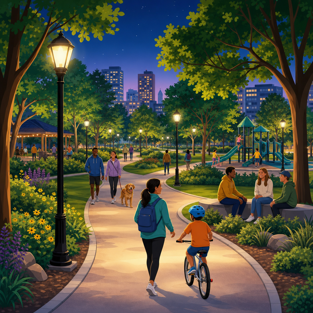
Safe routes through parks shape whether public green space feels welcoming after school, before sunrise, and during evening commutes. In urban development practice, a safe route is not merely a path with pavement; it is a connected corridor designed so people can see, be seen, orient themselves easily, and encounter enough legitimate activity to deter harm. Lighting refers to the quality, placement, and consistency of illumination. Sightlines describe how clearly users can view what lies ahead, beside, and behind them, without visual obstruction from walls, dense shrubs, grade changes, or poorly placed structures. Activation means programming and designing for regular, positive use: walkers, vendors, maintenance crews, dog owners, cyclists, families, and staff whose presence creates natural surveillance.
I have worked on park access audits where a route looked acceptable on a daytime plan set yet failed completely at dusk because fixtures created glare, planting blocked corners, and trail entrances sat hidden behind utility buildings. That gap between design intent and lived experience matters. Parks connect neighborhoods, schools, transit stops, senior housing, and commercial streets. If routes through them feel unsafe, people take longer detours, avoid active travel, or stop using the park altogether. The result is lower foot traffic, weaker public health outcomes, and less equitable access to public space.
Safe park routes also matter for climate and transportation goals. Cities encourage walking and cycling to reduce emissions, but mode shift depends on people trusting everyday routes at all hours. A greenway that closes off intuitive movement after dark weakens the larger mobility network. Designing safer routes therefore supports sustainability, public health, social cohesion, and economic vitality at once. The strongest park circulation plans combine environmental sensitivity with practical security principles. They balance habitat protection, dark-sky concerns, maintenance capacity, accessibility, and user comfort rather than treating safety as a single equipment purchase or police issue alone.
Designing for visibility and orientation
The first rule of safer park circulation is simple: users should understand where a path goes, who else is nearby, and how to exit quickly if needed. That sounds obvious, yet many parks fail at basic orientation. Hidden bends, fragmented entrances, and overly layered landscaping increase uncertainty. In site reviews, I start by walking each route from likely origins such as transit stops, school gates, parking lots, and neighborhood sidewalks. If a first-time visitor cannot instantly identify the main path, destination markers, and nearest public street, the design is already working too hard against human behavior.
Good visibility begins with path alignment. Routes intended for regular through-movement should minimize blind corners and sudden grade drops. Curves are not inherently unsafe, but they need wide radii, clear edge definition, and enough forward visibility for users to see oncoming people and cyclists. Intersections should be legible from a distance through paving contrast, sign placement, and lighting hierarchy. Wayfinding works best when it reduces decision points rather than adding clutter. Consistent path widths, recognizable landmarks, and direct connections to surrounding streets are more valuable than decorative complexity.
Sightlines depend heavily on landscape management. Shrubs near path edges should stay below roughly thirty inches where visibility across space is important, while tree canopies should generally be lifted above eye level to preserve views under branches. This common parks and streetscape principle is often summarized as low plantings and high canopies. It is not a rigid formula for every habitat zone, but it is a reliable baseline for circulation corridors, trailheads, comfort stations, and seating areas. Where ecological goals require denser planting, designers should offset vegetation from the route or create transparent viewing windows at intervals.
Structures deserve the same scrutiny. Restrooms, pump houses, cafés, maintenance yards, retaining walls, and public art can either frame activity or create concealment. The safest placement usually keeps active fronts facing primary routes and avoids dead zones behind service areas. Transparent materials, windows, and open fencing allow buildings to contribute to oversight instead of blocking it. Seating should support comfort without trapping users in isolated pockets. Benches near visible nodes, entrances, playgrounds, and sports areas perform better than benches hidden deep within screened alcoves.
Universal accessibility strengthens safety because a route that is easy to navigate for wheelchair users, older adults, children, and people with low vision is usually easier for everyone. That means continuous accessible surfaces, limited cross slopes, detectable edges where needed, and clear transitions between shared-use paths and pedestrian-only zones. The Americans with Disabilities Act standards and related public-rights-of-way guidance do more than support compliance; they improve predictability. Predictable spaces reduce confusion, and reduced confusion lowers perceived risk.
Lighting that supports safety without overlighting
Lighting is one of the most misunderstood elements of park safety. Brighter is not automatically better. Poorly aimed fixtures can create glare, deep shadow contrast, and false reassurance. Effective park lighting prioritizes vertical illumination, uniformity, color rendering, and fixture placement over raw brightness. Users need to recognize faces, detect motion, read signs, and understand edges. That requires balanced light on the walking environment and adjacent features, not stadium-style intensity blasting only the ground plane.
In practice, primary circulation routes need a consistent lighting rhythm that matches path hierarchy. Main commuter or connector paths usually warrant pole-mounted fixtures spaced to avoid dark gaps and harsh hot spots. Secondary recreational trails may need lower levels, timed operation, or seasonal hours depending on ecology and expected use. LEDs are now standard because they offer energy efficiency, long life, and control options, but the specification matters. Correlated color temperature should often stay warmer in parks to support visual comfort and reduce ecological disruption, while still maintaining adequate color recognition.
Controls are as important as fixtures. Photocells, dimming schedules, motion-responsive layers near low-use segments, and remote monitoring can improve reliability and reduce operating cost. A dark fixture is worse than no fixture because users assume coverage exists. Maintenance teams therefore need asset inventories, outage reporting, and replacement schedules. I have seen newly renovated paths lose public trust within months because a handful of failed luminaires remained unrepaired. Reliability is a security feature.
Good lighting design also considers edges. Entrances, map signs, emergency call locations, crossings, underpasses, bridges, and transitions to adjacent streets should receive special treatment because uncertainty spikes where environments change. Underpasses deserve particular care: walls and ceilings should be light colored and graffiti resistant, corners should remain open, and lighting should continue beyond the tunnel mouth so users do not walk toward a black void. If an underpass cannot be made open and legible, an at-grade crossing may be safer and more inviting.
Dark-sky and habitat concerns are real. Parks often contain waterways, migratory routes, and nocturnal species sensitive to artificial light at night. The solution is targeted design, not abandoning illumination where people genuinely need it. Full cutoff fixtures, lower mounting heights in selected areas, warmer light, curfews for nonessential zones, and route prioritization can protect ecology while supporting evening access on key corridors. The Illuminating Engineering Society provides useful outdoor guidance, but local ecology and operations data should shape final decisions.
Activation and natural surveillance
A route feels safer when legitimate users are present consistently and the surrounding environment signals care. This is the practical meaning of activation. It does not require constant events or commercialization. It means aligning park design, adjacent land uses, and operations so that paths are observed and used throughout the day. The strongest examples place playgrounds, cafés, recreation courts, community gardens, restrooms, and staffed facilities along major routes rather than scattering them in isolated pockets.
Natural surveillance grows from ordinary activity. Parents watching children, grounds crews working, seniors exercising, commuters cycling through, and staff opening facilities all add eyes on the path. In mixed-use districts, park edges with transparent ground-floor uses and frequent entrances usually outperform edges backed by blank walls, parking lots, or fenced utility compounds. Even a small kiosk can improve perceived safety if it increases routine presence near a key gateway. Programming should reinforce daily rhythms: morning walking groups, after-school recreation, weekend markets, and evening classes at adjacent community centers all extend the period of legitimate use.
Maintenance is activation’s quiet partner. Broken lights, overflowing bins, damaged signs, and unmanaged vegetation communicate low oversight. People notice these cues instantly. A clean, functioning route with visible stewardship feels safer because it suggests someone is responsible and nearby. Operations teams should inspect high-use paths on a defined schedule, especially after storms, festivals, or seasonal growth spurts. Digital work-order systems can help park agencies respond faster and track recurring problem locations.
| Design element | How it improves safety | Common failure |
|---|---|---|
| Active entrance plaza | Creates visible gathering point and clear transition from street to park | Entrance hidden behind landscaping or service uses |
| Layered lighting plan | Supports face recognition, wayfinding, and edge definition | Glare, dark gaps, inconsistent fixture spacing |
| Managed vegetation | Preserves sightlines along curves, nodes, and crossings | Overgrown shrubs blocking views and signs |
| Regular programming | Increases legitimate presence at predictable times | Events concentrated only in one zone or season |
| Visible maintenance | Signals stewardship and speeds hazard correction | Slow response to outages, litter, or vandalism |
Activation has limits. A quiet habitat trail will never function like an urban square, and it should not be forced to. In those areas, safety may depend more on selective hours, strong trailhead information, ranger visibility, and clear alternatives than on trying to create round-the-clock use. The right question is not how to make every route busy; it is how to match route purpose, context, and expected use with an appropriate level of visibility, support, and management.
Operations, data, and community trust
Safe routes through parks are sustained through management, not completed at ribbon cutting. Agencies need a repeatable method for identifying problems and adjusting conditions. That starts with data, but not only incident reports. Reported crime is a lagging and incomplete signal because many users change behavior long before incidents are logged. Better inputs include pedestrian counts, lighting outage records, 311 requests, maintenance logs, near-miss reports, user surveys, and escorted walk audits with residents, disability advocates, and front-line staff.
In my experience, dusk and dawn audits reveal the most actionable information. During these walks, teams can document glare, hiding spots, inaccessible detours, informal desire lines, and moments where users hesitate. Mapping those observations alongside actual route demand often shows that a park’s most important corridor was never designed as the main corridor at all. People carve their own safe route toward bus stops, corner stores, or school entrances. A successful hub article on this topic should emphasize that user behavior is evidence, not noncompliance.
Community trust is equally important. If residents report feeling unsafe and the only response is a promise of more patrols, agencies miss the broader design and operations problem. Trust grows when park managers explain what will change, on what schedule, and why. Quick wins matter: trimming vegetation, replacing failed lamps, repainting tunnel walls, relocating signs, or opening an additional gate can produce immediate confidence. Longer-term capital projects should then address structural issues such as entrance relocation, path realignment, drainage, and building frontage.
Partnerships strengthen performance. Business improvement districts, schools, conservancies, public works departments, transportation agencies, and community groups often control adjacent conditions that shape safety inside the park. Crosswalk timing, curb ramps, bus stop placement, storefront transparency, and sidewalk lighting all influence whether the route into the park feels intuitive and secure. The most effective cities treat park routes as part of the public realm network, not as isolated recreational amenities.
Balancing safety, ecology, and long-term resilience
Park safety must be durable under heat, storms, flooding, and budget pressure. Materials, fixtures, and planting plans should support both resilience and visibility. Permeable paving can reduce runoff on key routes, but only if it remains smooth and maintainable. Bioswales can frame paths beautifully, yet they need edge definition so users understand where to walk at night. Trees provide shade and thermal comfort, which increase route use during hotter months, but species selection and pruning plans should preserve canopy clearance over time.
Resilient design also means creating redundancy. If one entrance floods, is there another obvious way through? If a power outage occurs, do reflective markings, passive sightlines, and nearby active edges still support navigation? If a path is closed for habitat restoration, are detours direct, accessible, and clearly signed? Safety is strongest when it does not depend on a single layer. Well-planned routes combine passive design, active management, and user information so that no single failure collapses the whole system.
The core lesson is straightforward: safe routes through parks emerge from the interaction of lighting, sightlines, and activation, supported by disciplined operations. None of those elements works well alone. A bright path with blind corners still feels risky. A visible route with no evening use can feel deserted. Active programming without maintenance quickly loses credibility. When cities coordinate these factors, parks become dependable links in daily life rather than spaces people avoid after dark.
For planners, designers, and park managers, the practical next step is to evaluate one priority route from edge to edge at dusk. Check whether entrances are obvious, whether faces are recognizable under lighting, whether planting preserves views, whether adjacent uses add watchful presence, and whether maintenance signals care. Then fix the small failures quickly and plan the larger ones systematically. Safer park routes expand access, support walking and cycling, and make public green space work for more people, more often. Start with the route people already want to take, and make it reliably safe.
Frequently Asked Questions
What makes a park route feel genuinely safe, not just technically accessible?
A genuinely safe park route does more than connect point A to point B. It creates conditions where people can move comfortably, read their surroundings quickly, and avoid feeling isolated or trapped. In practice, that means combining smooth, continuous pathways with clear lighting, open sightlines, intuitive wayfinding, and regular signs of legitimate activity. A route may meet accessibility standards and still feel unsafe if it has dark gaps, hidden corners, confusing turns, or stretches with no nearby users. Safety is strongly influenced by perception as well as design performance.
For most users, a safe route is one where they can see ahead, understand where the path leads, identify exits or connections, and feel visible to others rather than concealed. Design features that support this include consistent path width, unobstructed views, visible entrances, limited blind spots, and transitions that make sense between streets, park edges, and interior destinations. Routes near active uses such as playgrounds, sports courts, transit stops, community buildings, or well-used streets often feel safer because they benefit from passive observation and natural foot traffic.
Maintenance also plays a major role. Burned-out lights, overgrown vegetation, damaged pavement, graffiti on signs, and litter can signal neglect, which tends to undermine confidence even if crime levels are low. A safe route is therefore not a one-time capital improvement. It is an ongoing management commitment that combines design, operations, landscape care, and community presence so people can use the park at different times of day with less uncertainty.
How should lighting be designed for safe routes through parks?
Lighting should be designed to support visibility, orientation, and comfort rather than simply making a space brighter. Good park-route lighting helps users identify faces, detect movement, notice changes in the path surface, and understand what lies ahead without creating harsh glare or deep shadow. The goal is consistent illumination along the route, especially at entrances, intersections, stairs, ramps, underpasses, crossings, seating areas, and decision points where people need more visual information.
Uniformity matters as much as brightness. A route with a few very bright fixtures and several dark patches can feel less safe than one with moderate, even light levels. Sudden contrast makes it harder for the eye to adjust and can conceal hazards or people standing just outside the brightest zone. Fixture height, spacing, shielding, and beam direction all affect whether light reaches walking surfaces effectively and whether users can see beyond the immediate pool of light. Well-placed lighting should reveal the path, adjacent landscape edges, and likely areas of approach without spilling excessively into sensitive habitats or nearby homes.
Designers also need to consider the experience of different users. People walking alone before sunrise, caregivers with children after school, older adults with reduced night vision, and bicycle commuters moving at higher speeds all rely on lighting in different ways. In many cases, a layered approach works best: path lighting for travel, accent lighting at entrances and landmarks for orientation, and targeted lighting at nodes where people gather or cross. Equally important is reliability. Smart controls, routine inspections, rapid repair protocols, and vandal-resistant fixtures help ensure the lighting strategy functions in real conditions rather than only on opening day.
Why are sightlines so important in park safety planning?
Sightlines are central to park safety because they shape how quickly users can assess risk, make decisions, and remain aware of other people and available exits. When a path allows someone to see well ahead, they can identify whether the route is occupied, where it bends, whether there is an alternative connection, and whether anything appears unusual. Poor sightlines create uncertainty. Sharp curves, dense shrubs, hidden alcoves, solid walls, grade changes, and poorly placed structures can make users feel vulnerable because they cannot anticipate what is around the corner.
Strong sightlines do not require stripping a park of character or vegetation. Instead, they rely on thoughtful arrangement. Trees with high canopies often preserve visibility better than dense, low plantings. Seating, signage, public art, utility boxes, and kiosks should be positioned so they do not block key views along primary routes. At entrances and intersections, users should be able to orient themselves immediately and understand where the main circulation path continues. Where topography or existing structures limit visibility, designers can compensate by widening the path, improving lighting, increasing nearby activity, or creating alternate routes that feel more open.
Clear sightlines also support informal supervision. Other park users, adjacent residents, passing cyclists, maintenance staff, and people in nearby active spaces all contribute to a sense that the route is part of a shared public realm rather than a secluded corridor. This is one reason edge conditions matter so much. Routes that run alongside active streets, community facilities, or programmed spaces often feel safer than routes tucked behind blank walls or deep landscape buffers. In short, sightlines help people feel they can read the environment and that the environment can read them back.
What does “activation” mean, and how does it improve safety on park routes?
Activation refers to the presence of legitimate, everyday use that keeps a space socially alive. On a park route, activation can come from nearby destinations, scheduled programming, visible staff presence, food kiosks, recreation areas, exercise zones, dog runs, transit access, public restrooms, and community events. The safety benefit comes from predictability and presence. When people expect to encounter others engaged in normal activities, a route feels less isolated and less available for harmful behavior.
Importantly, activation is not the same as overcrowding or nonstop programming. A route can be effectively activated through small, well-placed uses that create periodic foot traffic and passive oversight throughout the day. For example, locating a playground near a main path can increase after-school presence, while morning fitness classes, commuter bike traffic, and weekend markets can extend the route’s usefulness beyond a single peak period. The key is to support a pattern of legitimate occupancy that matches how the park and surrounding neighborhood actually function.
Activation works best when paired with physical design. A lively destination hidden behind walls or disconnected from the main path will not contribute much to perceived safety. The most successful park routes place active uses where they are visible from circulation corridors and where circulation corridors are visible from those uses. This mutual visibility helps reinforce natural surveillance. Management matters too. Programming schedules, vendor policies, maintenance routines, and partnerships with community organizations can all strengthen activation over time. In that sense, activation is both a design strategy and an operational strategy for making routes feel used, cared for, and publicly shared.
How can cities and park managers balance safety improvements with comfort, ecology, and good public-space design?
Balancing safety with comfort and ecology requires rejecting the false choice between secure parks and beautiful parks. The best park routes are both. They provide enough illumination for visibility without washing out the night environment, maintain clear sightlines without removing all habitat value, and support regular activity without turning every green space into a hard-surfaced event zone. A well-designed route should feel calm, legible, and welcoming while still respecting ecological systems, neighborhood context, and the park’s intended character.
That balance starts with prioritizing the route itself. Primary circulation corridors usually need stronger lighting, better wayfinding, more frequent maintenance, and tighter vegetation management than passive natural areas. Designers can preserve darker habitat zones away from main travel paths while ensuring that key commuting and access routes remain visible and intuitive. Planting design can also support both goals: low groundcovers and higher-canopy trees often maintain ecological and aesthetic value while preserving views better than dense shrubs at eye level. Materials, benches, railings, and signage should be durable and coordinated so the route feels cared for rather than heavily securitized.
Public engagement is another critical piece. Different users experience safety differently depending on age, gender, mobility, language, familiarity with the park, and time of travel. Listening to those patterns helps cities target improvements where they matter most instead of relying on generic solutions. Post-occupancy evaluation is equally important. Agencies should review whether people are actually using the route more often, whether dark spots or hidden areas remain, and whether maintenance and programming are keeping up with design intent. When safety measures are integrated thoughtfully, the result is not a park that feels controlled; it is a park that feels readable, active, and comfortable enough for everyday use.