Micromobility parking is the overlooked system that determines whether shared scooters and bikes feel like a clean transit option or a sidewalk nuisance. In city after city, the same pattern repeats: fleets launch quickly, adoption rises, and then complaints pile up because devices are left across curb ramps, bus stops, storefronts, and narrow pedestrian paths. “Micromobility parking solutions” means the policies, physical infrastructure, software controls, and operating practices used to guide where small vehicles can be parked after a trip. When those solutions work, sidewalks stay passable for wheelchair users, parents with strollers, seniors, and everyone else trying to move safely through public space.
I have worked on curb management and dockless deployment reviews, and the hard lesson is simple: clear sidewalks do not happen because riders are told to “park responsibly.” They happen when cities and operators design for compliance. Good parking management matters because micromobility is growing as a practical part of sustainable urban development. Shared bikes and scooters can reduce short car trips, improve first-and-last-mile access to transit, and lower transport emissions. Yet the public will not support expansion if the system shifts costs onto pedestrians, especially disabled residents who are blocked by poorly parked vehicles. Sidewalk access is not a cosmetic issue; it is a basic mobility, safety, and equity requirement.
The most effective hub approach starts with a realistic definition of the problem. Sidewalk obstruction comes from several sources at once: weak curb regulations, too little designated parking, poor rider instructions, inaccurate GPS, inconsistent enforcement, and street designs that leave no obvious place for a device other than the footway. Solving the issue requires coordination across transportation departments, public works, accessibility offices, transit agencies, and private operators. This article explains the parking models that actually keep sidewalks clear, where each model works best, what tradeoffs to expect, and how cities can build a durable program instead of reacting complaint by complaint.
Why sidewalk clutter happens in the first place
Most parking failures are system failures, not simply rider misbehavior. A dockless rider usually ends a trip at the destination edge, not at a carefully planned storage point. If the nearest legal space is vague, hidden, or inconvenient, many users will choose the obvious empty patch of pavement. That is especially true during peak demand near rail stations, campuses, nightlife districts, and commercial corridors. In my experience, the worst clutter appears where curb use is already contested by deliveries, ride-hail pick-ups, bus boarding, cafe seating, and ADA access needs. Without dedicated micromobility space, the sidewalk becomes the default overflow zone.
Technology contributes as well. Standard smartphone GPS can drift several meters in dense urban streets, under tree cover, or beside tall buildings. That means a rider may believe they ended a trip in a compliant location while the system records a position inside a no-parking zone or on the wrong side of the curb. Operators that rely only on geofencing often discover that digital boundaries are not precise enough to protect a narrow pedestrian clear zone. Operations matter too. If rebalancing teams do not sweep high-demand areas frequently, devices accumulate at corners and in front of major destinations even when some users parked reasonably.
Accessibility standards make the stakes concrete. The pedestrian access route must remain open, continuous, and predictable. In practice, cities often target a clear through-zone of at least 6 feet, though exact requirements vary by local design guidance and context. Parking that leaves a scooter angled across a curb ramp, detectable warning surface, or transit stop boarding area is unacceptable even if the rest of the sidewalk seems wide. Any serious parking program therefore starts by mapping conflict points rather than treating all curb segments the same.
What parking solutions work best in real streets
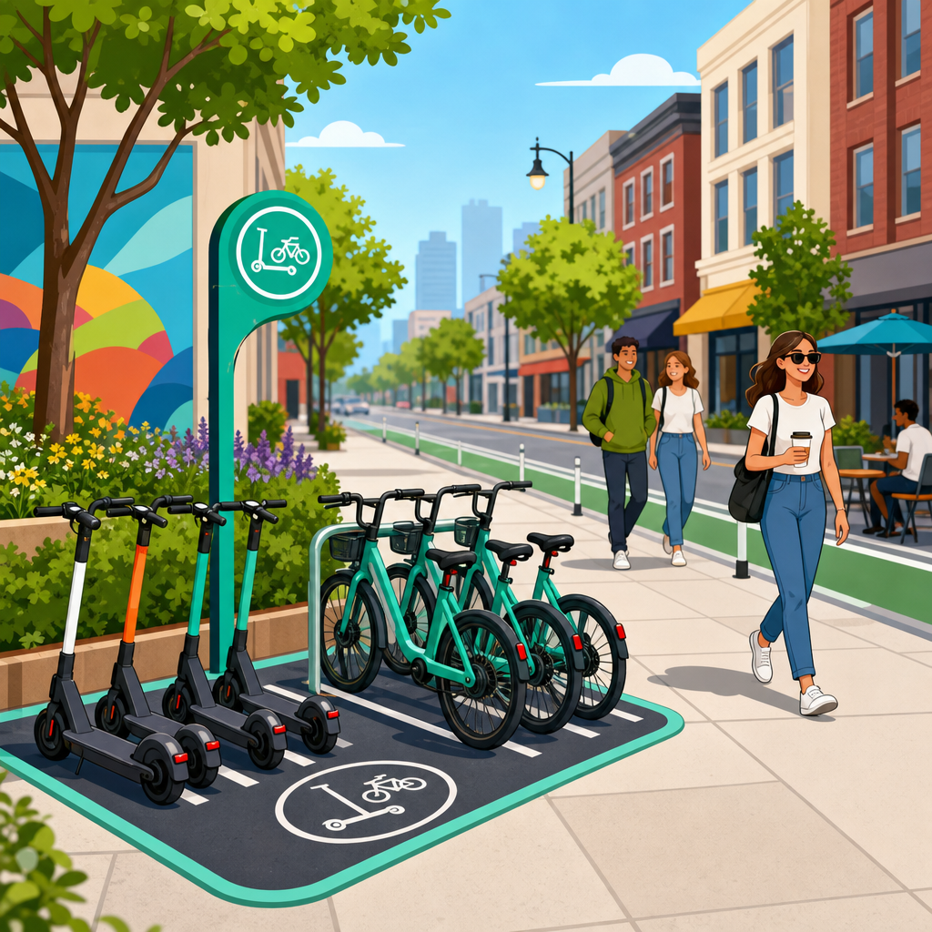
The best-performing cities use a layered strategy rather than one universal rule. Dedicated on-street corrals are the strongest tool because they remove the parking decision from the pedestrian realm and place devices in the carriageway or curb lane, often where one car space can hold eight to 12 scooters or six to 10 bicycles depending on layout. Paint-and-post corrals are relatively inexpensive, fast to install, and highly legible. They work especially well on commercial streets with recurring demand and limited sidewalk width. Riders can see where to park, and enforcement officers can immediately spot violations outside the corral.
Mandatory end-of-trip parking zones are the next most reliable option. Instead of allowing parking anywhere outside a red no-parking area, the app only lets a user complete a ride inside approved zones. This model works best in dense downtowns, around transit stations, and in historic districts where every foot of walkway matters. It does require enough zone coverage to avoid frustrating users. If the approved spaces are too sparse, riders abandon trips incorrectly or stop using the service altogether. The winning balance is frequent, visible parking areas placed where trips naturally end.
Hybrid systems often outperform pure docking or pure dockless models. For example, a city may permit free-floating use in lower-density neighborhoods where sidewalks are wide and demand is dispersed, while requiring designated parking in the core. Another practical model uses virtual parking zones supported by physical cues such as signs, pavement markings, and modular racks. The physical cue matters. I have seen compliance improve substantially when a digital box in the app is paired with real street treatment that tells riders, pedestrians, and enforcement staff exactly what the space is for.
| Parking approach | Where it works best | Main advantage | Main limitation |
|---|---|---|---|
| On-street corral | Commercial corridors, transit hubs, downtown blocks | Highest sidewalk protection and strong visual compliance | Requires curb space reallocation and maintenance |
| Mandatory parking zones | Dense centers, campuses, event districts | Prevents trip completion in sensitive pedestrian areas | Needs many well-placed zones to avoid user friction |
| Hybrid dockless plus designated areas | Mixed-density cities | Balances convenience with control | Rules can become confusing without clear signage |
| Full docking system | High-capacity bike networks, commuter markets | Excellent order and predictable storage | Higher capital cost and less flexible coverage |
Full docking still has a role, particularly for public bike share systems with strong commuter demand and station-based planning. Docking provides the cleanest sidewalk outcome because the storage geometry is fixed. The tradeoff is cost, slower expansion, and less flexibility for rapid network adjustments. For scooters, docking is less common, but lock-to requirements using racks or designated fixtures can deliver many of the same benefits where theft risk and clutter are both concerns.
Design standards that prevent obstruction before enforcement begins
Micromobility parking works when the street design makes the legal choice easier than the illegal one. The first design principle is separation from the pedestrian through-zone. Whenever possible, place parking in the furnishing zone, curb extension, flex lane, or a converted car parking space rather than in the middle of the sidewalk. Near intersections, keep devices out of daylighting areas so they do not block sight lines between drivers and people crossing. Near bus stops, preserve boarding and alighting space. Near ADA curb ramps, maintain direct access without protrusions.
Capacity planning matters more than many programs admit. A single painted box that holds six scooters may fail every afternoon outside a rail station that receives 60 arrivals per hour. Right-sizing locations based on observed turnover, not rough estimates, is critical. Good operators and city staff use trip-end heat maps, field audits, and seasonal demand patterns to size corrals properly. They also cluster parking at destinations with repeated surges: schools at dismissal, stadiums on event nights, waterfronts on weekends, and office districts at commute peaks.
Material choices influence behavior. Posts, wheel stops, bollards, and branded signs create legibility. Surface markings fade, and app maps alone are invisible once a rider has dismounted. In several curb pilots I have reviewed, adding vertical elements increased proper parking because users no longer had to guess whether a space was intended for scooters, deliveries, or short-term car parking. The best installations also include straightforward instructions, such as “Park fully within marked area” and “Keep curb ramp clear,” because riders respond better to specific directives than generic reminders.
Street context should shape the solution. In narrow historic centers, almost any sidewalk parking will create conflicts, so mandatory on-street corrals are usually necessary. In suburban downtowns with wider sidewalks and lower pedestrian volumes, designated sidewalk-edge zones may be acceptable if a continuous clear path is protected. On university campuses, the most common issue is vehicle concentration near building entrances, so high-frequency corrals paired with strong campus rules usually outperform broad free-floating permissions.
How software, operations, and enforcement make parking rules stick
Physical design solves only part of the problem. The rest depends on software rules, field operations, and credible enforcement. End-of-trip photo verification is now standard for many operators, and it should be. A clear photo allows automated checks and human review when complaints come in. Some platforms use computer vision to flag likely obstructions, such as scooters lying on their side or parked across a path. Photo review is not perfect, but it raises compliance when paired with warnings, fines, or temporary suspensions for repeat offenders.
Geofencing is useful, but it must be calibrated honestly. A broad geofence can stop parking near a plaza or transit portal, yet it cannot by itself guarantee that the device is placed neatly inside a legal zone. Better systems combine geofencing with Bluetooth beacons, QR-coded parking signs, or camera-based confirmation to improve accuracy at the curb level. Operators also need service-level agreements for response times. If a blocked curb ramp complaint sits for six hours, the policy has already failed the people most affected.
Enforcement should focus on outcomes, not symbolic penalties. Cities need a documented escalation ladder: rider education for first mistakes, user fines for repeated improper parking, operator penalties when complaint response times or fleet distribution targets are missed, and permit reductions for chronic noncompliance. Public dashboards help. When cities publish improper parking rates, response times, and complaints by neighborhood, weak spots become visible, and operators have a reason to improve. This is also where equity enters the picture. Enforcement and parking supply should not be concentrated only in affluent downtown blocks while outer neighborhoods receive weak service and messy curb conditions.
Operations teams are often the hidden factor behind successful programs. Rebalancing crews that proactively relocate devices before school dismissal or train arrivals prevent pileups better than crews that react after complaints. Staff training matters too. Workers need a map of sensitive locations, including hospitals, senior centers, and accessible loading zones, because a single poorly staged vehicle at those sites causes outsized harm.
What cities should measure and how to build a scalable program
The right performance metrics are straightforward. Track the percentage of trips ending in a designated parking area, average time to resolve an obstruction complaint, number of devices found blocking the pedestrian access route during audits, and repeat offense rates by user and by operator. Add contextual measures such as utilization per parking corral, turnover by time of day, and parking availability near major destinations. These numbers reveal whether the issue is behavior, insufficient supply, or uneven operations. Complaint totals alone are not enough because they reflect reporting habits as much as actual conditions.
A scalable program usually starts with a pilot in the highest-conflict districts, then expands block by block. Begin where demand is obvious and sidewalks are constrained: downtown transit stations, entertainment corridors, and major campus edges. Install visible corrals, set mandatory parking in the app, publish response-time rules, and conduct weekly field audits for at least three months. Then adjust based on evidence. If one location overflows daily, enlarge it. If another sits empty, move it closer to actual destinations. Micromobility parking should be managed like any other curb asset: measured, priced or regulated where necessary, and redesigned as demand changes.
Integration with the broader transportation network is the final step. Parking should support transit access, not compete with buses, paratransit, freight, or pedestrian priority. The strongest programs coordinate micromobility zones with bike lanes, station entrances, curb management plans, and streetscape upgrades. That coordination is what turns parking from a defensive tactic into a genuine urban mobility tool.
Keeping sidewalks clear is not about banning scooters or hoping riders behave better. It is about building a parking system that matches real travel patterns, protects accessibility, and uses the curb intentionally. The evidence from successful programs is consistent: dedicated on-street corrals, mandatory parking zones in dense areas, strong physical cues, end-of-trip verification, fast complaint response, and measured enforcement produce the best results. Cities that rely on vague rules and sparse infrastructure continue to fight the same obstruction problems year after year.
For sustainable urban development, this matters far beyond aesthetics. A well-managed micromobility network expands low-carbon mobility, improves transit connections, and reduces friction between new transport modes and the people already using public space. The main benefit is simple: orderly parking makes micromobility easier to support politically and easier to use safely in everyday life. If your city is planning or reforming a program, start by mapping conflict points, converting selected curb space into visible parking, and measuring compliance from day one. Clear sidewalks are achievable when parking is designed as core infrastructure, not an afterthought.
Frequently Asked Questions
What are micromobility parking solutions, and why do they matter so much for sidewalk access?
Micromobility parking solutions are the full set of tools cities and operators use to make sure shared scooters and bikes are parked in predictable, legal, and unobtrusive places. That includes physical infrastructure such as painted parking corrals, bike racks, in-street parking zones, modular docks, and designated curbside areas. It also includes policy rules, permit conditions, rider education, geofenced parking requirements in apps, photo verification at trip end, and field staff who rebalance or correct bad parking quickly. In other words, parking is not a single feature. It is a system.
These solutions matter because parking is where the public experience of micromobility is often won or lost. A city can support low-emission transportation, expand first-and-last-mile connections, and reduce short car trips, but if scooters and bikes consistently block curb ramps, bus stops, building entrances, or narrow pedestrian routes, the entire service starts to feel disorderly and inaccessible. That is especially true for wheelchair users, blind and low-vision pedestrians, older adults, parents with strollers, and anyone navigating a crowded sidewalk. When parking works well, micromobility feels like part of the transportation network. When parking fails, it feels like street clutter.
The reason parking deserves so much attention is simple: fleet growth can happen much faster than streets are redesigned to absorb it. Operators can deploy devices quickly, ridership can rise quickly, and problem locations can emerge almost overnight. Without a clear parking strategy, devices naturally gravitate toward the most convenient drop-off points for riders, which are not always the most appropriate places for the public realm. Effective parking solutions create structure without killing convenience. They give riders obvious places to end trips, preserve pedestrian access, and reduce the complaint cycle that often drives political backlash.
Which parking approaches actually keep sidewalks clear in real-world city environments?
The approaches that work best are usually layered, not standalone. The most reliable strategy combines clearly designated parking areas, strong app-based trip-ending controls, visible curb management, and active operations from the operator. Painted corrals on wide sidewalks can help in some contexts, but many cities are finding that curbside or in-street parking bays are more effective because they remove the parking function from the pedestrian zone entirely. Repurposed car parking spaces, flex zones, and protected on-street micromobility corrals often do a better job of keeping pathways open while still being convenient to riders.
Geofenced parking rules are another major piece of the puzzle. If a rider cannot end a trip unless the device is within an approved parking zone, compliance improves substantially. However, geofencing works best when the approved spaces are frequent, intuitive, and accurately mapped. If the nearest legal parking area is too far away, riders become frustrated and may abandon the device improperly anyway. Good implementation means pairing digital enforcement with enough physical parking supply in the places where trips actually begin and end, such as near transit stops, commercial streets, campuses, and dense residential blocks.
Photo verification can add another layer of accountability. Requiring users to submit a photo at trip end helps operators review parking quality, identify repeat violations, and coach or penalize riders when needed. On its own, though, photo review is not enough. The strongest programs use photos alongside targeted rebalancing teams, response-time requirements for correcting obstructions, and escalating enforcement for chronic misuse. Physical design also matters: parking areas should be easy to spot, close to destinations, and designed so devices naturally line up in an orderly way rather than spilling into walking space.
What consistently underperforms is a strategy that relies only on user goodwill or only on painted markings with no enforcement. Sidewalks stay clear when riders know where to park, the app supports that behavior, the street design makes the right action easy, and operators are held responsible for fast correction when things go wrong.
How can cities prevent scooters and bikes from blocking curb ramps, bus stops, storefronts, and other sensitive areas?
The first step is identifying sensitive areas explicitly and treating them as no-parking or no-stopping zones within both policy and software. Curb ramps, accessible loading areas, transit boarding zones, crosswalk approaches, fire hydrants, storefront entrances, school gates, and narrow sidewalk segments should never be left to rider interpretation. Cities should map these areas carefully and require operators to incorporate them into geofenced no-parking boundaries. That creates a baseline rule set that protects the most critical parts of the pedestrian environment.
The second step is shifting parking demand to places that are nearby and more appropriate. Riders are much more likely to comply when there is a designated parking option within a short, visible distance of where they want to go. This is why curbside micromobility corrals, bike racks near retail clusters, and transit-adjacent parking zones are so important. If a city bans parking around sensitive locations without creating practical alternatives, noncompliance tends to rise. Good curb management means replacing ambiguity with nearby, clearly marked options.
Enforcement and operations are just as important as rules. Permit terms should require operators to remove or correct obstructing devices within strict time windows, especially where accessibility or transit access is affected. Cities should also require operator staffing plans that include proactive sweeps of known hot spots, not just reactive responses after complaints arrive. Repeated parking violations by users can trigger warnings, fines, or temporary account restrictions. Repeated operator underperformance can trigger permit penalties, fleet caps, or deployment reductions. Clear consequences matter.
Finally, cities should use complaint data, 311 reports, ADA feedback, and on-the-ground audits to refine parking networks over time. The best systems are not static. They respond to where conflicts actually occur. If a storefront corridor, bus transfer point, or hospital frontage repeatedly sees obstruction, that is a signal to redesign the parking layout, add more designated space, increase field operations, or tighten software rules. Sidewalk clearance improves fastest when cities treat parking as an actively managed network rather than a one-time rollout decision.
Are dockless systems always worse for sidewalk clutter, or can they be managed effectively?
Dockless systems are not automatically worse, but they do require stronger management because flexibility can easily turn into inconsistency without guardrails. The main advantage of dockless micromobility is convenience. Riders can begin and end trips closer to their origins and destinations, which supports adoption and makes the service more useful for short urban trips. The tradeoff is that flexibility increases the chance of poor parking unless the city and operator establish a disciplined parking framework.
Dockless systems can be managed effectively when they operate more like “flexibly parked within structured rules” rather than “park anywhere.” In practice, that means designated parking zones in high-demand areas, no-parking protections in sensitive pedestrian locations, trip-end geofencing, user prompts in the app, and active fleet management by operators. Some cities also use hybrid models, where dockless vehicles must park at hubs in the busiest districts but can use more flexible rules in lower-density areas with wider sidewalks and less conflict. That kind of context-sensitive management often produces better results than one blanket rule citywide.
Docks can provide stronger order by design, and in some places they are the right choice, especially where public agencies want very clear parking behavior and permanent infrastructure. But docks are not the only way to keep sidewalks clear. A well-run dockless program with enough designated parking supply, visible markings, operator accountability, and data-driven oversight can perform much better than a poorly planned docked or semi-docked system. The real issue is not whether vehicles are dockless. It is whether parking expectations are clear, enforceable, and supported by the street environment.
For many cities, the practical answer is not choosing one model forever but matching the parking model to the corridor. Dense downtowns, transit hubs, and retail main streets often benefit from formal hubs or corrals. Lower-density neighborhoods may be able to support more flexible parking with lighter-touch controls. Sidewalk clutter becomes manageable when the system is designed around actual urban conditions rather than ideology.
What should cities and operators measure if they want to know whether their micromobility parking strategy is actually working?
The most important metric is not just how many trips occur, but how often devices are parked correctly and whether pedestrian access remains clear. Cities should track parking compliance rates through field audits, operator-submitted trip-end photos, and periodic independent inspections. They should also measure obstruction frequency in specific high-risk locations such as curb ramps, transit stops, school frontages, and narrow sidewalk corridors. If the strategy is working, those conflict points should show a downward trend over time, even as ridership grows.
Complaint data is also essential, but it should be interpreted carefully. A high number of complaints may indicate a real parking problem, but it can also reflect high awareness or uneven reporting patterns. That is why complaint volume should be paired with response times, verified obstruction rates, and spatial analysis of recurring hot spots. The key question is not only how many complaints arrive, but whether operators resolve them quickly and whether the same locations continue to generate problems after interventions are made.
Cities should also evaluate parking supply and convenience. If riders are frequently ending trips just outside designated zones, or if geofence failures and trip-end friction are common,