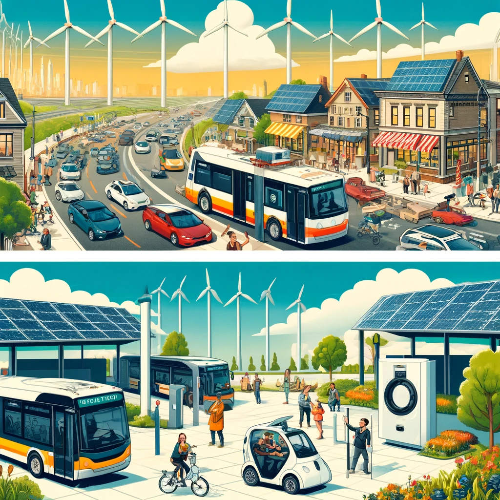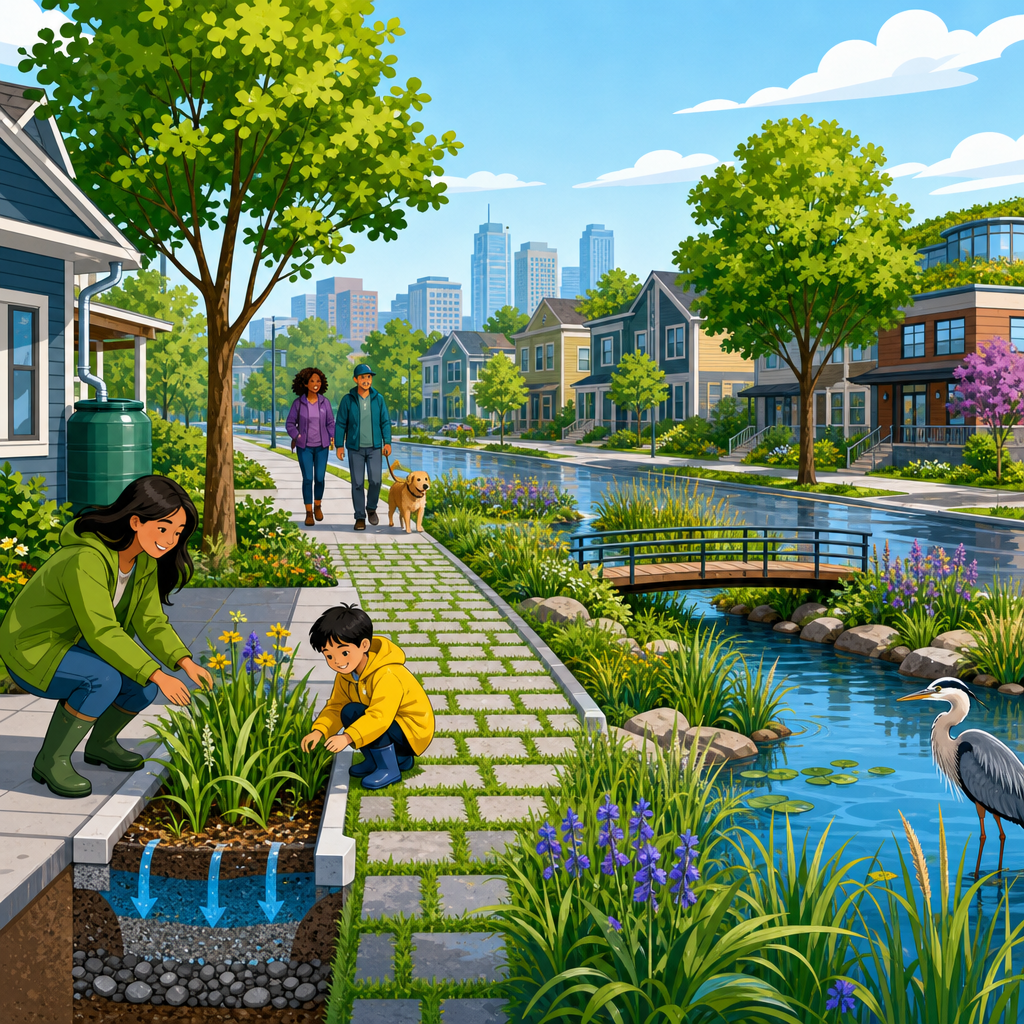
Blue-green infrastructure for flood-prone neighborhoods combines water-focused systems and living landscape features to reduce runoff, limit flood damage, and improve daily urban life. In practice, “blue” refers to water bodies and drainage networks such as streams, ponds, swales, wetlands, and detention basins. “Green” refers to vegetation-based elements such as trees, rain gardens, bioswales, green roofs, permeable planting zones, and connected parks. When these systems are planned together, they slow stormwater, store it temporarily, filter pollutants, support cooling, and create usable public space. For neighborhoods that flood repeatedly after heavy rain, this approach is no longer a design trend; it is a core resilience strategy.
I have worked on urban stormwater and site planning projects where traditional drainage pipes were sized correctly on paper yet still failed during intense storms because runoff arrived too fast and too hot. That gap matters. Many flood-prone neighborhoods were built with large paved areas, undersized combined sewers, filled wetlands, and streams forced into culverts. Climate change is increasing the frequency of short, intense rainfall in many regions, while urbanization keeps adding impervious surface. The result is familiar: basement backups, street ponding, sewer overflows, damaged roads, mold, insurance claims, and public health risk. Blue-green infrastructure addresses those linked problems at the source by restoring infiltration, storage, and conveyance across the landscape instead of depending only on buried pipes.
The topic matters because flooding is rarely just a water problem. It is also a housing problem, a mobility problem, a public health problem, and an equity problem. Lower-income neighborhoods often carry the highest flood burden while receiving the least investment in parks, trees, and drainage upgrades. A well-designed blue-green infrastructure plan can reduce peak flows, improve water quality, cut heat exposure, expand habitat, and make streets safer to walk. It can also stretch municipal capital budgets because distributed systems often defer the need for oversized gray infrastructure. As a hub within sustainable urban development, this article explains the principles, components, planning methods, implementation choices, and performance measures that cities, developers, and community groups use to make flood-prone neighborhoods more resilient.
How Blue-Green Infrastructure Reduces Neighborhood Flood Risk
The basic function is straightforward: keep rain where it falls for longer, move it more slowly, and give it more places to soak in or be stored safely. Conventional drainage systems try to collect runoff quickly and send it downstream through pipes. That approach can protect one block while worsening flood peaks in another. Blue-green infrastructure changes the hydrology by increasing interception, infiltration, evapotranspiration, and temporary detention. Trees intercept rainfall on leaves and branches. Healthy soils absorb water. Bioswales convey runoff through shallow planted channels. Detention basins hold stormwater and release it gradually. Restored streams reconnect floodplains so high water can spread out without damaging homes.
Hydrologists usually describe stormwater behavior using volume, rate, and timing. Blue-green infrastructure improves all three. It can reduce total runoff volume through infiltration and plant uptake, lower peak discharge by delaying runoff, and lengthen the travel time to the drainage outlet. Even modest interventions matter when spread across a catchment. For example, a street retrofit with curb extensions, tree trenches, and permeable parking lanes may only capture the first inch of rainfall, but that first inch often contains the most frequent storm events and a large share of annual pollutant load. During larger events, the same system still slows inflow to pipes, which helps protect downstream inlets and outfalls from surcharge.
Performance depends on local conditions. Sandy soils infiltrate better than clay, steep streets require stronger erosion control, and high groundwater can limit underground storage. In older neighborhoods with combined sewers, reducing inflow is especially valuable because every gallon kept out of the system lowers the chance of combined sewer overflow. In coastal neighborhoods, designers must also account for tailwater conditions, tide locking, and sea level rise. The strongest plans pair distributed source controls with upgraded overflow paths, emergency storage, and clear maintenance protocols.
Core Elements Used in Flood-Prone Neighborhoods
Successful projects rarely rely on a single device. They use a network of complementary elements sized to the block, street, parcel, and watershed. The right combination depends on flood pathways, drainage area, soil type, and land ownership. In dense neighborhoods, small interventions repeated many times usually outperform one isolated showpiece.
| Element | Primary flood function | Best use case | Key limitation |
|---|---|---|---|
| Rain garden | Captures roof or sidewalk runoff and promotes infiltration | Residential lots, schoolyards, pocket parks | Needs suitable soil and routine weeding |
| Bioswale | Conveys and filters runoff in a vegetated channel | Road edges, medians, parking areas | Can clog if pretreatment is poor |
| Permeable pavement | Allows water through surface into stone reservoir below | Alleys, parking lanes, plazas | Less effective where sediment loads are high |
| Tree trench | Stores runoff in structural soil around street trees | Urban commercial streets | Requires utility coordination |
| Detention basin | Temporarily stores stormwater and releases it slowly | Parks, redevelopment sites, school grounds | Needs space and safe overflow design |
| Constructed wetland | Stores water, removes pollutants, supports habitat | Low-lying parcels and outfall zones | Requires mosquito and water level management |
| Green roof | Reduces runoff from rooftops and delays discharge | Multifamily and commercial buildings | Structural capacity can limit retrofits |
| Daylighted stream | Restores open flow path and floodplain function | Buried urban channels with recurring surcharge | High capital cost and land constraints |
These elements work best when linked. A roof drains to a cistern or rain garden, overflow enters a bioswale, the street sends excess water to a detention area, and the downstream park doubles as emergency storage during major storms. That “treatment train” approach improves reliability because no single component has to carry the full burden. It also allows phased implementation. A city can start with curbside bioswales and add schoolyard basins or creek restoration later as funding becomes available.
Planning and Design Principles That Prevent Failure
Good blue-green infrastructure begins with mapping, not planting. The design team needs topographic survey, storm sewer records, soil data, flood history, utility conflicts, groundwater depth, and realistic rainfall assumptions. I start by identifying nuisance flooding, building flood thresholds, inlet bypass locations, and overland relief routes, because neighborhood flooding often follows surface depressions rather than pipe alignments. Once those pathways are clear, the team can place storage and conveyance features where they intercept the most runoff with the least disruption.
Design should use a layered storm strategy. Frequent storms can be handled by source controls such as rain gardens, tree pits, and permeable surfaces. Moderate storms need distributed detention and protected street conveyance. Extreme storms require designated exceedance routes, storage in parks or plazas, and structures protected above expected water levels. This layered method is standard good practice because no neighborhood can infiltrate its way out of a cloudburst. Safe overflow is not optional. Every bioretention cell, basin, and curb inlet needs a defined path for water when capacity is exceeded or an outlet becomes blocked.
Maintenance must be designed in from the start. Many underperforming systems fail because access was poor, sediment pretreatment was skipped, or ownership was unclear. Specify cleanout points, forebays, inspection schedules, and vegetation plans suited to local climate and salt exposure. Use native or well-adapted species with deep roots and predictable growth. In cold climates, account for snow storage and sanding practices. In hot climates, provide establishment irrigation and mulch protection. The most durable projects treat operations as infrastructure, not landscaping afterthought.
Street Retrofits, Parks, and Buildings as a Connected System
Neighborhood resilience improves when streets, parks, schools, and buildings are planned as one hydrologic network. Streets are especially powerful because they occupy large public rights-of-way and already guide runoff. Converting selected lanes into permeable parking bays, adding curbside bioretention, and installing raised intersections can reduce ponding while calming traffic. Copenhagen, Rotterdam, and several U.S. cities have shown that streets can safely convey excess stormwater toward designated storage spaces instead of letting it enter homes. The key is to shape grades deliberately and protect critical destinations such as hospital entrances and transit stops.
Parks and schoolyards can serve as dual-use flood infrastructure. A depressed sports field, for example, can store runoff during a storm and return to normal use after drainage. Cloudburst parks in northern Europe and floodable playgrounds in North America demonstrate how public space can handle extreme events without becoming fenced utility land. In one common model, a neighborhood park receives overflow from nearby streets through vegetated channels, stores water in a basin below path level, and drains slowly through an outlet control. Residents gain trees, shade, and recreation while the drainage network gains surge capacity.
Buildings also play a direct role. Green roofs reduce rooftop runoff and lower roof surface temperature. Blue roofs temporarily store water on flat roofs under controlled release. Cisterns can collect roof runoff for irrigation or nonpotable uses where regulations allow. At ground level, downspout disconnection, permeable courtyards, and raised mechanical systems reduce flood damage. For multifamily housing in flood-prone neighborhoods, these measures are often more cost-effective when bundled into capital renewal cycles such as roof replacement, facade work, or parking lot rehabilitation.
Equity, Governance, and Funding in Real Neighborhoods
Technical design alone does not deliver resilient neighborhoods. The hardest problems are usually governance, maintenance responsibility, and fair distribution of investment. Historically underserved communities often have fewer trees, more pavement, older sewers, and more residents without flood insurance. If blue-green infrastructure is introduced only in high-visibility districts, cities may improve branding while leaving the highest-risk households exposed. Prioritization should combine hydraulic need with social vulnerability indicators such as income, age, health burden, renter concentration, and language access.
Community engagement must move beyond public meetings held after designs are mostly complete. Residents know where water enters basements, where children walk through flooded crossings, and which vacant lots stay wet for days. That local knowledge improves siting and avoids preventable mistakes. It also builds support for temporary disruption during construction. On several retrofit projects, the most useful field data came from resident photos taken during storms, not from outdated drainage maps.
Funding usually comes from a mix of stormwater utility fees, capital improvement budgets, resilience grants, transportation projects, parks funding, and private development requirements. Some cities use stormwater fee credits to encourage property owners to install green roofs or detention systems. Others tie runoff reduction to redevelopment approvals through retention standards based on design storms. Whatever the mechanism, long-term maintenance funding must be explicit. A rain garden without a maintenance line item is a short-lived asset. Contracts, inspection authority, and performance accountability should be settled before installation, not after the first clogged inlet.
Measuring Performance and Building a Long-Term Program
Blue-green infrastructure should be managed like any other municipal asset: with targets, monitoring, and adjustment over time. Useful metrics include runoff volume captured, peak flow reduction, infiltration rate, water quality improvement, frequency of street ponding, basement backup complaints, canopy cover, surface temperature reduction, and maintenance cost per acre treated. For larger programs, digital twins and calibrated hydrologic models such as EPA SWMM or PCSWMM help estimate catchment-scale effects. Field monitoring matters just as much. Water level loggers, soil moisture sensors, and post-storm inspections show whether systems perform as designed under real conditions.
It is important to be realistic about limits. Blue-green infrastructure will not eliminate all flood risk, especially in neighborhoods facing river flooding, storm surge, or extremely intense rainfall on tight urban soils. It also requires land, maintenance discipline, and cross-department coordination that many cities still lack. Yet the evidence from built projects is clear: neighborhoods with distributed storage, permeable surfaces, restored waterways, and healthier urban tree cover recover faster and experience less routine flooding than those relying only on pipes. The most effective programs start with pilot blocks, measure results, standardize details, and scale through street reconstructions, housing upgrades, and park renewals.
For sustainable urban development, the main lesson is simple: flood resilience works best when water is treated as a design input rather than a waste product to be removed as fast as possible. Blue-green infrastructure for flood-prone neighborhoods reduces damage, improves public space, and strengthens environmental performance at the same time. Cities, developers, housing providers, and community organizations should map flood pathways, identify priority blocks, and build a phased portfolio of projects that can grow over time. Start with the places that flood first and the residents who have the fewest resources to absorb another loss, then design a connected system that keeps working storm after storm.
Frequently Asked Questions
What is blue-green infrastructure, and why is it important in flood-prone neighborhoods?
Blue-green infrastructure is a coordinated approach to stormwater and urban landscape design that combines water-management systems with vegetation-based features to reduce flooding and improve neighborhood resilience. The “blue” side includes elements such as streams, ponds, wetlands, swales, detention basins, and drainage corridors that help move, store, or slow water. The “green” side includes trees, rain gardens, bioswales, green roofs, permeable planting areas, and connected parks that absorb rainfall, encourage infiltration, cool the environment, and support healthier streetscapes. In flood-prone neighborhoods, these systems are especially important because they work with natural water cycles instead of relying only on underground pipes and hard surfaces.
When planned together, blue-green infrastructure can reduce runoff volume, delay peak flows during storms, and lower the pressure on aging drainage networks. That means less standing water on streets, less basement flooding, and fewer disruptions to homes, schools, businesses, and transportation. Just as importantly, these investments can improve everyday quality of life by adding shade, habitat, recreational space, and more attractive public areas. In other words, blue-green infrastructure is not just about emergency flood control. It is a long-term neighborhood strategy that makes communities safer, healthier, and more adaptable to heavier rainfall and changing climate conditions.
How does blue-green infrastructure actually reduce flooding?
Blue-green infrastructure reduces flooding by managing rain where it falls and by slowing the movement of water through a neighborhood. In conventional urban areas, roofs, roads, sidewalks, and parking lots are often impermeable, which means rainwater runs off quickly into drains and pipes. During intense storms, that runoff can exceed the capacity of the drainage system, leading to street flooding, sewer backups, erosion, and property damage. Blue-green infrastructure interrupts that process. Features like rain gardens, bioswales, permeable landscapes, and tree pits capture rainfall close to its source, allowing some of it to soak into the soil, some to be stored temporarily, and some to be taken up by vegetation.
Larger blue elements such as wetlands, ponds, detention basins, restored channels, and overflow corridors provide additional storage and controlled release. Instead of water rushing all at once into one part of the system, these features spread, slow, filter, and route it more safely. Connected green spaces can also create room for water during peak storm events, reducing pressure on nearby streets and structures. This layered approach is what makes blue-green infrastructure effective: no single feature solves flooding on its own, but a network of interventions can significantly reduce risk. Over time, these systems also help improve soil structure, support groundwater recharge in suitable locations, and make neighborhoods better prepared for both frequent small storms and more severe rainfall events.
What are the most effective blue-green infrastructure features for residential neighborhoods?
The most effective features depend on local soils, topography, drainage patterns, land availability, and the scale of flooding, but several tools consistently perform well in residential settings. Rain gardens and bioswales are often among the most practical because they can be placed along streets, in medians, near downspouts, or within shared open space to collect and filter runoff. Street trees and expanded planting zones are also highly valuable because their canopies intercept rainfall while their roots improve soil permeability and reduce surface runoff. Permeable planting strips, curb extensions designed for stormwater capture, and vegetated swales can all help keep water out of overloaded storm drains.
At the building and block scale, green roofs, cisterns, rain barrels, and redirected roof drainage can help reduce the amount of water entering the system during storms. At the neighborhood scale, larger interventions such as detention basins, constructed wetlands, daylighted streams, retention ponds, and floodable parks can provide critical storage and conveyance capacity. In many cases, the strongest results come from combining smaller distributed measures with a few larger shared assets. For example, a neighborhood may use tree trenches and rain gardens to manage frequent runoff, while a detention basin or wetland handles larger storm events. The best blue-green infrastructure strategy is usually one that links private lots, public rights-of-way, parks, and drainage corridors into one coordinated system rather than relying on isolated projects.
Can blue-green infrastructure improve daily neighborhood life beyond flood control?
Yes, and this is one of the main reasons blue-green infrastructure has become such an important urban planning strategy. While flood reduction is often the starting point, the same features that manage water can also make neighborhoods more comfortable, attractive, and functional every day. Trees, planted swales, rain gardens, and green roofs help cool urban areas by reducing heat buildup, which can be especially beneficial in densely developed neighborhoods with limited shade. Green spaces and connected park systems can provide places to walk, gather, exercise, and spend time outdoors, improving both physical and mental well-being.
Blue-green systems can also improve water quality by filtering pollutants before runoff reaches streams, rivers, or downstream infrastructure. They can support biodiversity by creating habitat for birds, pollinators, and aquatic species. In some neighborhoods, these improvements can help calm traffic, beautify streets, and make public spaces feel more welcoming. Economically, better-designed landscapes may support property stability, reduce long-term infrastructure costs, and lower the expense of repeated flood damage. For communities that have historically dealt with chronic flooding, neglected infrastructure, or a lack of green space, blue-green infrastructure can be part of a broader neighborhood revitalization effort. The key is thoughtful design that balances performance, access, maintenance, and equity so that benefits are shared by the people who live there.
What should communities consider before investing in blue-green infrastructure projects?
Before investing in blue-green infrastructure, communities should begin with a clear understanding of their flood risks, drainage challenges, and neighborhood priorities. A successful plan starts with data: where water collects, how storm drains perform, what soils are present, how land slopes, which properties are repeatedly affected, and how future rainfall patterns may change. It is also important to understand existing infrastructure conditions, including whether pipes are undersized, whether outfalls are constrained, and whether there are opportunities to reconnect parks, vacant land, school grounds, or waterways into a functioning stormwater network. Without that context, it is easy to install attractive features that provide only limited flood protection.
Communities should also evaluate maintenance capacity, long-term funding, and resident involvement. Blue-green infrastructure is not a one-time installation; it needs inspection, sediment removal, plant care, and periodic upgrades to keep working well. Equity should be a central consideration too, especially in neighborhoods that have faced disinvestment or repeated flood losses. Residents should have a voice in where projects go, how public space is designed, and how benefits such as shade, access, safety, and reduced flood risk are distributed. Finally, communities should view blue-green infrastructure as part of a broader resilience strategy that may also include updated zoning, building protections, emergency planning, sewer and drainage upgrades, and policies that limit new development in the highest-risk locations. The most effective investments are integrated, community-informed, and designed to perform reliably over the long term.