Urban water systems are invisible until something goes wrong, and few failures carry more public health urgency than lead service lines, hidden leaks, pressure loss, and contamination events. Urban tech for lead pipe detection and water system monitoring brings these risks into view by combining utility records, field inspections, sensors, geographic information systems, machine learning, and asset management software. In practical terms, it means cities can find hazardous pipes faster, prioritize replacements more fairly, and monitor distribution networks continuously instead of reacting after residents report brown water or low pressure. I have worked with municipal infrastructure data and utility mapping projects, and the pattern is consistent: the communities that modernize detection and monitoring workflows reduce uncertainty, improve capital planning, and communicate better with residents.
Lead pipe detection refers to the process of identifying lead service lines, connectors, goosenecks, and premise plumbing materials that may leach lead into drinking water. Water system monitoring refers to the ongoing measurement of flow, pressure, water quality, and network condition across treatment plants, mains, service connections, valves, pumps, and storage assets. These two functions are tightly linked. A city cannot build a credible lead replacement plan without a reliable inventory, and it cannot protect water quality after replacement work without monitoring disturbances, disinfectant residuals, and corrosion control conditions. Regulatory pressure has intensified this need. The U.S. Environmental Protection Agency’s Lead and Copper Rule Improvements, state-level inventory mandates, and rising expectations for digital transparency have made manual, fragmented approaches inadequate for large urban systems.
This matters to housing markets because water infrastructure quality affects property value, insurance costs, tenant confidence, renovation timelines, and municipal credit perception. Buyers increasingly ask whether a home has a lead service line. Multifamily owners want proof of water quality risk management. Developers need confidence that surrounding infrastructure can support density without chronic breaks or pressure problems. For cities, better monitoring reduces non-revenue water, lowers emergency repair costs, and improves prioritization of capital budgets. For residents, the benefit is more direct: lower exposure risk and clearer information. The most effective urban tech stack does not rely on one miracle device. It uses layered evidence, from historical tap cards and predictive models to potholing, X-ray fluorescence screening, acoustic leak detection, smart meters, and network analytics, so decisions are based on verified data rather than assumptions.
How cities detect lead service lines at scale
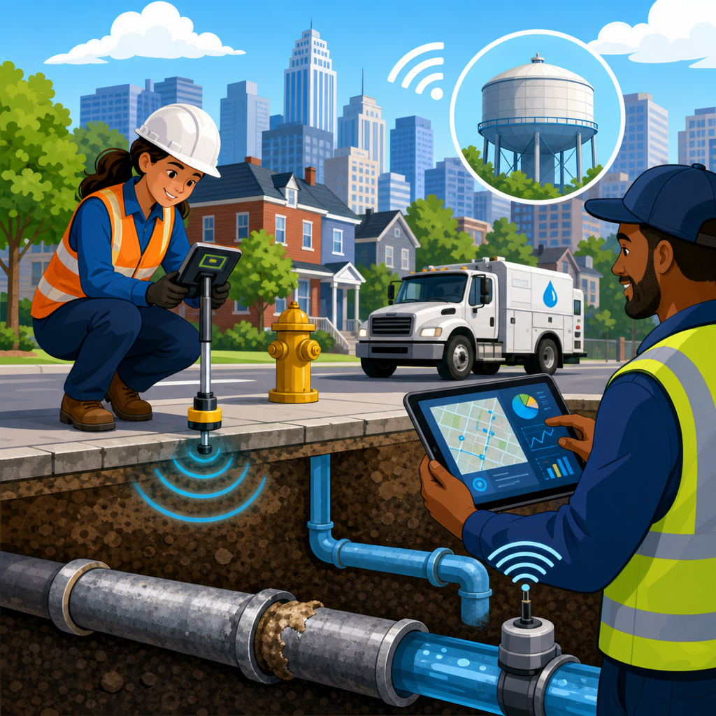
The core challenge in lead pipe detection is that the most dangerous assets are often buried, undocumented, or recorded in inconsistent language. Utilities may have century-old index cards showing abbreviations such as “Pb,” “L,” “galv,” or simply blank fields. Parcel age can suggest risk, but it is not proof. In my experience, the most successful cities build a lead service line inventory by combining five evidence sources: historical records, parcel and construction data, field observations, resident self-reporting, and direct verification. Historical records include permit books, utility tap cards, plumbing inspections, and meter installation notes. Parcel data adds construction year, remodel dates, ownership type, and neighborhood characteristics. Field observations come from meter pits, curb boxes, basement entries, vacuum excavation, and replacement crews. Resident reporting can add photos from the water entry point, especially when guided by a structured survey. Direct verification then confirms uncertain cases through excavation or inspection.
Machine learning helps cities sort uncertainty when records are incomplete. A predictive model can analyze housing age, prior service line material observations, adjacent parcel data, street construction history, and neighborhood installation patterns to estimate the probability that a given address has lead or galvanized requiring replacement. Cities such as Newark, Denver, and Washington, D.C., have used data-driven inventory methods to accelerate identification, though every prediction still requires field confirmation before final replacement decisions. The value of the model is triage. Instead of inspecting properties randomly, utilities can send crews to the blocks most likely to contain lead. This raises inspection productivity and shortens the time between inventory development and shovel-ready replacement planning.
Verification technology matters because false confidence is expensive. Hydrovac excavation can expose the service line near the curb stop with minimal disruption. X-ray fluorescence analyzers can screen accessible pipe segments, though coatings, geometry, and mixed materials require trained interpretation. Sequential sampling at the tap can support risk assessment but should not be treated as a direct material identification method. Some cities also use machine vision in the field, capturing standardized photos of exposed pipe surfaces and linking them to GIS records for auditability. The strongest programs treat every material classification as evidence-based and traceable. If a resident challenges an inventory result, the utility should be able to show whether the classification came from a historic card, a crew observation, a verified excavation, or a predictive score awaiting confirmation.
Digital mapping, sensors, and analytics for water system monitoring
Water system monitoring starts with a digital network model that links physical assets to real-time and historical data. At minimum, an urban utility needs a GIS-based map of mains, valves, hydrants, service areas, pressure zones, tanks, and customer connections. That map becomes far more powerful when integrated with supervisory control and data acquisition systems, advanced metering infrastructure, customer information systems, work order management, and hydraulic modeling tools such as EPANET, InfoWater Pro, or OpenFlows WaterGEMS. Once these systems connect, utilities can see where pressure transients are occurring, which neighborhoods experience repeated breaks, how tank turnover affects disinfectant residuals, and where low flow may signal leakage or demand anomalies.
Common monitoring hardware includes pressure loggers, flow meters, water quality sondes, chlorine analyzers, turbidity sensors, level transmitters, and acoustic leak detection devices. Smart meters add customer-side usage patterns that can reveal continuous flow from leaks, unusual vacancy consumption, or sudden demand drops after shutoffs. Fixed acoustic sensors on mains can listen for leak signatures and send alerts when sound profiles change. Pressure sensors installed across district metered areas help utilities isolate bursts quickly and understand whether fire flow events or pump operations are causing harmful transients. For water quality, continuous monitoring of pH, oxidation-reduction potential, conductivity, temperature, and disinfectant residual supports faster response to changes that could affect corrosion control or microbial risk.
The operational value comes from analytics, not just instrumentation. A city with hundreds of sensors still fails if alarms are poorly calibrated or data is trapped in separate software systems. Good monitoring programs define thresholds, escalation rules, and maintenance routines. They distinguish between nuisance alerts and true incidents. They also pair raw sensor feeds with hydraulic context. For example, a drop in chlorine residual near a dead-end main means something different than the same reading in a high-turnover downtown loop. Likewise, a pressure dip during a scheduled valve exercise should not trigger the same response as an unplanned nighttime pressure collapse. Utilities that mature beyond dashboard watching build anomaly detection workflows, root-cause analysis playbooks, and post-incident reviews that improve thresholds over time.
Where urban tech creates the most value
Not every technology investment delivers equal benefit. The strongest returns usually come from a sequence: build a defensible inventory, digitize asset data, target field verification, deploy monitoring in high-risk zones, and use findings to prioritize capital work. Lead service line programs benefit when GIS records, customer communication, contractor schedules, and replacement status are unified in one system of record. Water monitoring programs benefit when utilities create district metered areas and baseline normal conditions before adding more sensors. Starting with governance is usually smarter than starting with hardware. If naming conventions, asset IDs, and inspection forms are inconsistent, expensive analytics produce weak conclusions.
| Technology | Primary Use | Best Urban Application | Main Limitation |
|---|---|---|---|
| GIS asset mapping | Spatial inventory and planning | Lead service line inventory, break history, replacement routing | Only as reliable as source records and update discipline |
| Predictive modeling | Risk scoring and prioritization | Targeting likely lead addresses for inspection | Requires validated training data and field confirmation |
| Hydrovac verification | Direct material confirmation | Minimal-disruption inspection near curb stop | Higher unit cost than record review |
| Pressure and flow sensors | Operational monitoring | Burst detection, district metered areas, pressure management | Needs calibration, communications, and alarm tuning |
| Smart meters | Customer-side demand visibility | Leak alerts, billing accuracy, consumption trend analysis | Privacy concerns and rollout complexity |
| Water quality analyzers | Continuous quality surveillance | Residual tracking, treatment distribution verification | Sensor fouling and maintenance burden |
Equity is another area where urban tech adds measurable value. Legacy replacement programs often favored blocks with louder complaints or easier construction conditions. A data-based approach can balance public health risk, child population, income vulnerability, school proximity, and documented material likelihood. That does not mean algorithms should make policy alone. It means city leaders can see the tradeoffs clearly and publish prioritization criteria residents can understand. Several utilities now maintain public dashboards that show completed replacements, pending verifications, and known or suspected lead locations by neighborhood. Transparency reduces distrust, especially where residents have long assumed that infrastructure investments bypassed their communities.
There is also a housing and redevelopment angle. When utilities publish accurate service line data, property transactions become less uncertain. Landlords can plan replacements before turnover. Affordable housing developers can incorporate water service upgrades into rehabilitation budgets. Mortgage and inspection professionals can advise buyers more clearly. In this way, urban water technology supports not only compliance and operations but also neighborhood stability. Reliable infrastructure information lowers hidden-risk premiums that otherwise distort investment decisions in older housing stock.
Implementation challenges, governance, and what successful cities do differently
The hardest part of modernization is rarely buying technology. It is standardizing data, training field crews, and keeping systems current after the pilot phase. Utilities commonly struggle with duplicate asset IDs, mismatched parcel addresses, contractor data that arrives in unusable formats, and field teams that classify pipe materials differently. Successful cities solve this with strict data governance. They define controlled vocabularies for material types, confidence levels, and inspection methods. They require mobile forms with mandatory fields and photo capture. They sync GIS edits to work management systems daily instead of reconciling months later. They also audit a sample of inspections to confirm that crews apply classification rules consistently.
Cybersecurity and communications resilience are equally important. Water utilities are critical infrastructure, and connected monitoring devices expand the attack surface. The Cybersecurity and Infrastructure Security Agency and the American Water Works Association both emphasize segmentation, multifactor authentication, patch management, access logging, and incident response planning. Cities deploying internet-connected sensors should avoid unsecured default configurations and should document firmware versions, network paths, and vendor support obligations. Reliability is not only about malicious threats. Cellular dead zones, battery failures, and sensor drift can silently degrade monitoring quality. A robust program tracks device health, not just asset conditions.
Successful cities also communicate with residents in plain language. If an address is listed as “unknown” in the lead inventory, the city should explain what that means, what evidence exists, and what steps will resolve the status. If a sensor-triggered event leads to flushing or temporary discoloration, residents need timing, location, and health guidance quickly. In projects I have seen work well, utilities coordinate public works, health departments, call centers, and neighborhood organizations before launching major inventory or sensor programs. That coordination turns technical data into practical action. It also protects trust, which is essential when asking residents for access to basements, meter rooms, or service lines on private property.
What this hub means for housing market decisions
Urban tech for lead pipe detection and water system monitoring is now a basic part of responsible city management, not an experimental add-on. For the housing market, it provides a clearer picture of infrastructure risk at the parcel, block, and neighborhood level. For utilities, it supports faster lead identification, better replacement planning, lower water loss, and stronger incident response. For residents and property owners, it replaces guesswork with documented evidence. The most effective approach is layered: historical records, predictive analytics, direct verification, GIS integration, targeted sensors, and disciplined governance. No single tool solves everything, but together they create a measurable, auditable system for safer water.
As this subtopic hub grows, the core question remains simple: how can cities make buried infrastructure visible enough to manage it well? The answer is through accurate inventories, continuous monitoring, and transparent communication tied to real operational workflows. Cities that invest in these capabilities protect public health, improve capital efficiency, and reduce uncertainty for buyers, renters, landlords, and developers. If you are evaluating housing market trends in older urban neighborhoods, start by reviewing the local lead service line inventory, utility monitoring practices, and replacement progress. Those signals reveal far more about long-term housing resilience than curb appeal ever will.
Frequently Asked Questions
What is urban tech for lead pipe detection and water system monitoring?
Urban tech for lead pipe detection and water system monitoring refers to the mix of digital tools, field methods, and utility workflows that help cities understand what is happening inside their drinking water infrastructure. Instead of relying only on outdated paper records or waiting for failures to become visible, utilities use a combination of historical service line records, geographic information systems (GIS), inspection data, water quality sampling, pressure and flow sensors, leak detection tools, machine learning models, and asset management platforms to identify risks earlier and respond more effectively.
For lead pipe detection specifically, this technology helps utilities determine where lead service lines are likely to exist, even when installation records are incomplete or inconsistent. Cities can combine permit data, property age, neighborhood construction history, excavation results, and predictive modeling to create prioritized replacement lists. For broader water system monitoring, urban tech helps identify hidden leaks, pressure changes, contamination risks, abnormal consumption patterns, and infrastructure deterioration before they escalate into service disruptions or public health emergencies.
The biggest advantage is visibility. Water systems are mostly underground and easy to ignore until something goes wrong. These tools make the invisible network easier to map, monitor, and manage. That allows cities to prioritize limited budgets, protect vulnerable populations, improve compliance, and make better long-term decisions about repairs, replacements, and public communication.
How do cities actually detect lead service lines if the pipes are buried underground?
Detecting lead service lines usually requires a layered approach because no single method is perfect. Many cities begin with records review, looking at tap cards, plumbing permits, utility installation logs, property age, and neighborhood development patterns. Homes built during certain periods are more likely to have lead service lines or lead-containing connectors, so historical context can be very useful. Utilities often load this information into GIS systems to create searchable maps and identify clusters of likely risk.
From there, field verification becomes important. Utilities may perform visual inspections at meter connections, service entry points in basements, curb stops, or during road and water main projects. Crews can sometimes identify pipe material by appearance, scratch testing, magnet testing, or using inspection cameras where conditions allow. Some cities also conduct vacuum excavation or potholing to expose a small section of the buried service line for confirmation without performing a full replacement.
More advanced programs combine these findings with predictive analytics. Machine learning models can estimate the probability that a property has a lead service line based on known pipe materials nearby, construction dates, previous inspection results, and local installation practices. These models do not replace field verification, but they help utilities prioritize inspections and replacements much faster than manual review alone. The result is a more efficient process that reduces uncertainty, shortens timelines, and helps cities focus first on the homes and neighborhoods most likely to be at risk.
What role do sensors and real-time monitoring play in modern water system management?
Sensors and real-time monitoring are central to modern water system management because they allow utilities to detect changes as they happen instead of learning about problems after residents report them. Across a distribution network, utilities can install sensors that measure pressure, flow, water quality indicators, tank levels, pump performance, acoustic leak signatures, and other operational conditions. When these systems are connected to telemetry platforms, supervisory control and data acquisition systems, or cloud-based dashboards, operators gain near real-time visibility into the health of the network.
This matters for both infrastructure performance and public health protection. A sudden pressure drop may indicate a main break, valve issue, or pump failure. Unusual flow patterns can suggest hidden leaks, unauthorized use, or meter problems. Water quality sensors may detect changes in chlorine residual, turbidity, conductivity, temperature, or pH that warrant investigation. In some systems, continuous monitoring helps identify conditions that could increase corrosion risk, which is especially important when a utility is managing lead exposure concerns.
Real-time monitoring also improves response speed and operational efficiency. Instead of sending crews to investigate broad areas, utilities can narrow down likely problem locations and dispatch resources more strategically. Over time, the data collected by sensors supports trend analysis, maintenance planning, and resilience planning. Utilities can see where pressure instability is recurring, where water loss is increasing, or where equipment performance is deteriorating. In short, sensors turn the water system from a reactive operation into a more proactive, data-driven one.
How do GIS, machine learning, and asset management software work together to improve water infrastructure decisions?
These technologies are most powerful when they are connected. GIS serves as the geographic backbone, showing where pipes, valves, hydrants, meters, service lines, customer accounts, and inspection results are located. It allows utilities to visualize assets spatially, see patterns by neighborhood or pressure zone, and overlay relevant information such as property age, road work schedules, environmental conditions, or demographic indicators. Without GIS, much of the data remains fragmented and harder to act on.
Machine learning adds another layer by helping utilities find patterns that are not obvious through manual review alone. For example, a predictive model can estimate which properties are most likely to have lead service lines, which pipe segments have elevated break risk, or which parts of the network are more vulnerable to leakage or low pressure events. These models use historical data and continuously improve as new inspection and maintenance information is added. They are especially useful when a utility has incomplete records and needs to make practical decisions under uncertainty.
Asset management software then turns these insights into action. It helps utilities organize inventories, assign condition ratings, track inspections, manage work orders, estimate lifecycle costs, and prioritize capital improvements. Instead of treating every pipe replacement or investigation as an isolated task, utilities can align risk data, regulatory requirements, maintenance history, and budget constraints in one decision-making framework. Together, GIS, machine learning, and asset management software help cities move from scattered information to coordinated planning, which is essential for replacing lead pipes faster, reducing water loss, and improving overall system reliability.
What are the main benefits of investing in lead pipe detection and water system monitoring technology?
The most important benefit is public health protection. When cities can identify lead service lines faster and monitor water system conditions more closely, they can reduce the risk of lead exposure, respond more quickly to contamination threats, and communicate more accurately with residents. This is especially important for children, pregnant women, and communities that have historically faced infrastructure neglect. Better detection and monitoring support more targeted interventions, such as prioritized service line replacement, corrosion control review, and neighborhood-specific outreach.
There are also strong operational and financial advantages. Utilities that can locate hidden leaks, detect abnormal pressure behavior, and verify asset conditions earlier often avoid more expensive emergency repairs later. Data-driven prioritization helps cities use funding more effectively, whether the money comes from local budgets, state revolving funds, or federal infrastructure programs. Rather than replacing assets based only on age or reacting to failures one by one, utilities can direct resources to the places where risk and impact are highest.
Another major benefit is transparency and trust. Residents want to know whether their service line contains lead, whether their utility is monitoring water quality carefully, and whether infrastructure decisions are being made fairly. Modern data systems make it easier to publish maps, provide status updates, document replacement progress, and support regulatory reporting. Over the long term, these technologies help utilities build more resilient and accountable water systems. They do not eliminate every challenge, but they give cities the tools to see problems sooner, plan more intelligently, and protect communities more effectively.