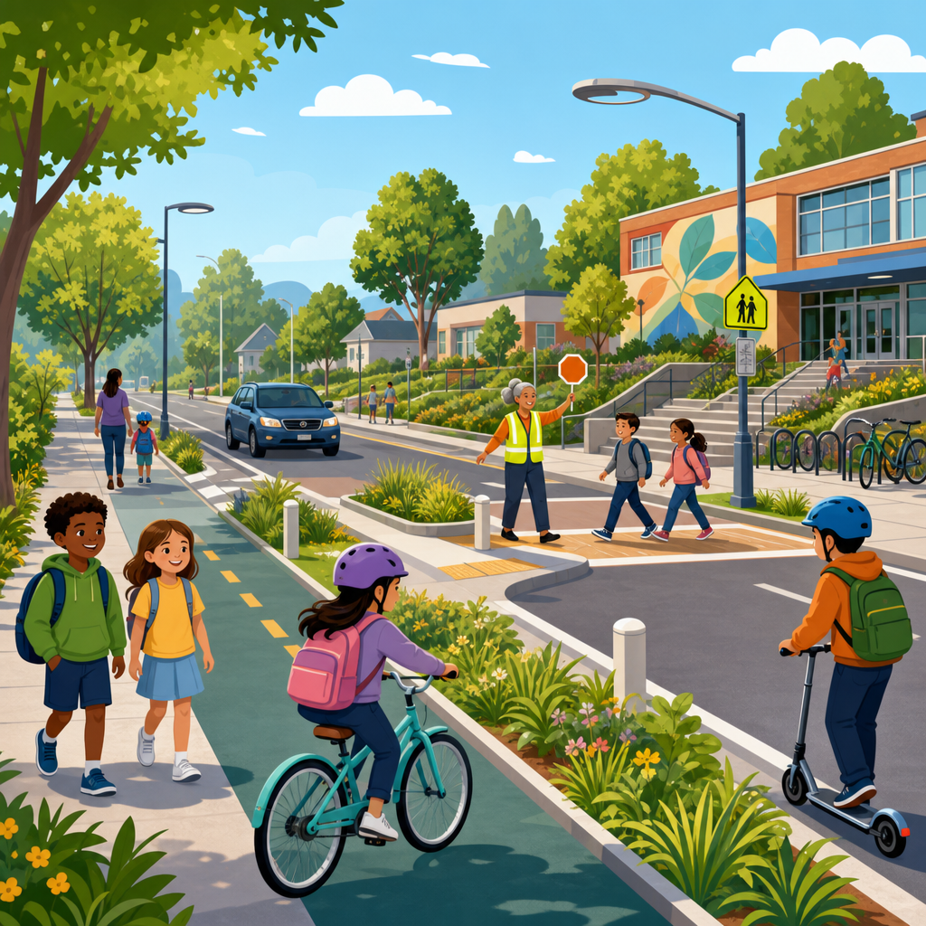
Safe Routes to School design is the practice of shaping streets, sidewalks, crossings, and surrounding land uses so children can walk, bike, and roll to school with a high level of safety, comfort, and independence. It goes far beyond painted crosswalks. A crosswalk stripe can highlight where people should cross, but it does not slow speeding drivers, shorten crossing distance, fix missing sidewalks, or calm chaotic pickup traffic. In my work reviewing school frontages and neighborhood circulation plans, the biggest gains have never come from paint alone. They come from coordinated design: lower operating speeds, protected space, clearer sight lines, simpler intersections, and school policies that reduce conflict at the curb.
The term Safe Routes to School usually refers both to infrastructure and to supporting programs such as education, encouragement, and enforcement. This article focuses on design, because the built environment sets the baseline for every trip. If a child faces a five-lane arterial with long signal cycles and no refuge island, no amount of safety messaging will make that route feel usable. Conversely, when routes include continuous sidewalks, frequent crossings, traffic calming, and protected bikeways, walking and cycling become normal choices rather than special events. That matters for public health, school access, traffic reduction, and climate goals. It also matters for equity. Families without reliable cars depend most on safe street networks, yet they are often served by the most dangerous roads.
School-area design also deserves attention because children are not miniature adults. Their field of vision is narrower, gap judgment is less reliable, and they are more affected by speed and complexity. Transportation engineers increasingly use a Safe System approach, which assumes people make mistakes and streets should be forgiving. Around schools, that means designing for low speeds and low conflict rather than expecting perfect behavior from children and drivers. The strongest school-route projects are therefore network projects. They improve the path from home to campus, the school frontage itself, and the arrival system at the gate. When cities treat Safe Routes to School as a paint-and-sign package, results are modest. When they redesign the corridor, intersection, and curbside together, injury risk drops and mode share changes follow.
Why painted crosswalks are not enough
Painted crosswalks have value as visibility markings and legal indicators, but on their own they provide little physical protection. Research and field practice both show that driver yielding depends heavily on speed, lane count, and sight distance. On a local street with low traffic volumes and speeds near 20 mph, a marked crosswalk can work well. On a wide collector or arterial, the same treatment can create false confidence if no supporting measures are present. Multiple-threat crashes are a classic example: one driver stops in the near lane, a child steps into the crosswalk, and a second driver in the far lane does not see the pedestrian in time.
This is why school-route design starts with context. Engineers look at posted speed, actual 85th percentile speed, crossing demand, turning volumes, truck presence, and the age range of students. A crosswalk serving an elementary school next to a busy multilane road typically needs a raised crossing, median refuge, rectangular rapid flashing beacon, full signal, or all of these depending on warrants and operating conditions. Advance yield markings and daylighting near the crossing help too, because parked cars frequently block a child’s visibility. The design objective is simple: make the crossing short, predictable, visible, and slow.
Another limitation of paint-only solutions is maintenance. Thermoplastic and high-durability materials last longer than ordinary paint, but markings fade, especially in snowy climates or under heavy bus traffic. If the route depends on stripes alone, safety degrades between restriping cycles. Physical elements age better. A curb extension continues to narrow the roadway. A raised intersection continues to slow traffic. A protected bike lane still separates users when markings become worn. In practice, the most resilient school-route projects use markings as one layer within a larger system, not as the system itself.
Street design fundamentals that actually protect children
The strongest predictor of injury severity is vehicle speed. That is the core fact every school design should start from. A person struck at 20 mph has a much higher chance of survival than a person struck at 40 mph. Because of that, successful Safe Routes to School projects focus first on reducing operating speed, not merely posting lower limits. Design tools include narrower travel lanes, vertical deflection such as speed humps and raised crosswalks, mini-roundabouts on neighborhood streets, tighter curb radii, and school-zone gateways that visually signal a different operating environment.
Sidewalk continuity is equally fundamental. Many school catchment areas still have sidewalk gaps, utility poles in the pedestrian zone, or curb ramps that do not meet ADA best practice. Children walking in grass shoulders or mud edges are pushed closer to traffic and are less visible at driveways. A good route provides a continuous accessible path, preferably buffered from moving vehicles by a furnishing strip, trees, bioswales, or parked cars where appropriate. That buffer is not cosmetic. It improves comfort, separates splashing and mirror strike risk, and increases the likelihood that families allow independent trips.
Intersections deserve disproportionate attention because they concentrate conflict. Tightened curb radii force slower turns. Leading pedestrian intervals can give walkers a head start before turning traffic moves. Protected intersection geometry can separate bike movements from turning vehicles. At unsignalized crossings, median islands allow children to deal with one direction of traffic at a time. In school audits, I often find that a single redesigned intersection unlocks an entire route because it removes the point parents fear most.
| Design element | Primary purpose | Best use near schools | Main limitation |
|---|---|---|---|
| Raised crosswalk | Slows vehicles and elevates pedestrians | Local streets, campus frontages, minor collectors | Needs drainage and emergency response review |
| Curb extension | Shortens crossing distance and improves visibility | Intersections with parking and high pedestrian demand | Can affect turning paths for larger vehicles |
| Median refuge island | Allows two-stage crossing | Wider streets with moderate to high traffic volumes | Requires sufficient roadway width |
| Protected bike lane | Separates riders from traffic | Routes serving older students and shared micromobility | Needs careful intersection design |
| Leading pedestrian interval | Reduces turning conflicts at signals | School-adjacent signalized intersections | Depends on signal equipment and timing strategy |
Designing the full journey from home to school
A school frontage can be excellent while the route to reach it remains stressful. That is why a hub view matters. The trip begins at the front door, not at the campus gate. Effective planning maps likely walking and cycling desire lines, then identifies barriers within roughly a one-mile walk shed for elementary schools and a larger bike shed for middle and high schools. Common barriers include missing sidewalks on just one block, drainage ditches without bridges, slip lanes, railroad crossings, and arterials with crossings spaced too far apart for a child’s patience or stamina.
Network connectivity is often overlooked. Cul-de-sacs, superblocks, and fenced school campuses may force children onto high-speed roads for short trips that should have been direct neighborhood walks. Midblock paths, cut-through connections, and open campus edges can dramatically shrink walking distance. I have seen routes drop from three-quarters of a mile to a quarter-mile simply by adding a path between two dead-end streets. That kind of connectivity improvement does more than save time; it keeps children off roads built for through traffic.
Designing the full journey also means planning for different users. Younger children walking with caregivers need wide sidewalks, shade, and frequent crossings. Older students on bikes need low-stress bikeways with predictable priority at intersections. Students using wheelchairs or mobility devices need smooth surfaces, compliant curb ramps, adequate turning space, and crossing time based on realistic walking speeds. The best plans test routes at the child’s eye level and in multiple conditions, including darkness, rain, and winter snow storage, because many problems only appear when school is in session and weather is poor.
The school frontage, arrival management, and curbside conflict
The most hazardous place on many campuses is not the nearest arterial intersection but the curb lane in front of the school during arrival and dismissal. Double parking, U-turns, blocked crosswalks, backing movements, and bus-car conflicts create a complex environment that children must navigate when they are distracted or excited. Good school-frontage design separates modes and sequences movements. Buses need dedicated loading areas. Family vehicle drop-off should be physically distinct from pedestrian entrances. Staff parking access should not cross the main student arrival path if it can be avoided.
Pick-up and drop-off loops can help in some contexts, but they are not automatically good design. A poorly sized loop can induce more driving, create long idling queues, and consume land that could serve safer walking entrances or green space. In many urban schools, the better solution is managed curbside access with time restrictions, off-street loading for buses, and strong pedestrian priority directly at the gate. Short-term changes such as cones and temporary barriers are useful for pilots, yet permanent materials produce more reliable behavior. Drivers respond to geometry more consistently than signs.
School frontage projects should also include daylighting, which removes parking close to intersections and crosswalks to improve sight lines. This is one of the simplest and most effective interventions. Adding bike parking in visible locations near entrances supports active travel, and covered racks improve year-round use. Where campuses generate heavy turning demand, transportation agencies should review signal timing and consider turn restrictions during arrival periods. The goal is a frontage that reads instantly: children first, vehicles second.
Equity, climate, and public health outcomes
Safe Routes to School is not only a traffic engineering issue. It sits at the intersection of equity, emissions, and health. Lower-income households are less likely to have flexible access to a car, and students in those neighborhoods often face more dangerous infrastructure, including high-injury corridors, poor lighting, and incomplete sidewalks. Prioritizing these routes is both a safety strategy and a fairness strategy. Agencies that use only parent survey pressure or grant-writing capacity to select projects often miss the places with the highest need.
There is also a measurable transportation benefit. When safe walking and biking options improve, a portion of school trips shift away from private vehicles, reducing congestion at the gate and on nearby streets. That can cut localized air pollution exposure during arrival times, when idling and stop-and-go traffic peak. For children, active travel also supports daily physical activity, attention, and independence. Not every student can walk or cycle, and some school siting patterns make that unrealistic, but better design increases the number who can.
Climate adaptation should be built into the design itself. Shade trees, cool pavements where appropriate, stormwater planters, and permeable features can make routes more resilient in heat and heavy rain. In warmer regions, lack of shade is a real barrier to walking. In flood-prone neighborhoods, a sidewalk that disappears under ponded water is not a sidewalk people can use. Sustainable urban development requires school routes that remain functional under everyday and extreme conditions, not just in a design drawing.
How cities should plan, measure, and improve routes over time
The best school-route programs begin with a multidisciplinary audit: transportation staff, school administrators, crossing guards, parents, and ideally students walking the route together. Crash history matters, but relying only on reported crashes is a mistake because near misses and chronic speeding often precede injuries. Cities should collect speed data, observe arrival operations, review sidewalk and ramp condition, and identify routes constrained by jurisdictional boundaries, such as state roads passing local schools.
Project selection should balance quick-build fixes with capital improvements. Quick-build tools include temporary curb extensions, paint-and-post refuges, daylighting, and revised striping. These help test designs fast. But agencies should move successful pilots into durable construction rather than leaving schools with temporary materials for years. Performance measures should include more than collision counts. Useful indicators include vehicle speed reduction, yielding rates, walking and biking mode share, crossing guard observations, and parent perception of safety before and after implementation.
Coordination is essential. School districts control bell times, entrances, and bus operations. Public works departments manage drainage and maintenance. Transit agencies may influence service to older students. Police can support targeted enforcement, but design should carry the main burden because enforcement is intermittent and can create equity concerns if applied unevenly. The enduring lesson from successful programs is straightforward: if a route feels safe to a cautious parent of a second grader, it is probably designed well. Cities and school districts should audit routes, fix the highest-risk links, and build networks that let more children arrive safely without needing a car every day.
Frequently Asked Questions
What does Safe Routes to School design include beyond painted crosswalks?
Safe Routes to School design includes the full set of physical and operational improvements that make it realistic for children to walk, bike, and roll to school safely and comfortably. Painted crosswalks are only one small part of that picture. A stripe on the pavement may indicate where people are expected to cross, but by itself it does not lower vehicle speeds, improve sight lines, reduce crossing distances, or protect children from turning traffic. Effective school-route design usually combines continuous sidewalks, accessible curb ramps, high-visibility crossings, median refuges, curb extensions, raised crossings, traffic calming, bikeways, school-zone speed management, and pickup and drop-off circulation strategies that reduce conflict and confusion.
Just as important, good design looks beyond the school property line. The route matters as much as the destination. If a child has to navigate missing sidewalks, wide curb radii, uncontrolled multilane crossings, speeding cut-through traffic, or poorly organized parking lots, the route will feel unsafe no matter how much paint is used near the front door. Strong Safe Routes to School planning also considers surrounding land uses, neighborhood connectivity, lighting, visibility, crossing guard locations, ADA accessibility, and the everyday behavior patterns of families and drivers. In practice, the goal is not simply to mark crossings, but to build an environment where slower speeds, predictable movements, and shorter, simpler crossings are built into the street itself.
Why aren’t painted crosswalks alone enough to protect students near schools?
Painted crosswalks are limited because they communicate intent but do not create meaningful physical protection. They can help make a crossing location more visible, but they do not force drivers to slow down or yield. If a street is too wide, if vehicle speeds are too high, if turning movements are fast, or if sight distance is poor, a marked crosswalk may give a false sense of security without addressing the main causes of risk. Children, especially younger students, have different judgment, visibility, and reaction abilities than adults, so relying on drivers to notice and respond correctly in every situation is not a strong enough safety strategy.
Real safety improvements come from changing the street conditions that produce conflict in the first place. That often means narrowing travel lanes, tightening curb return radii, adding raised elements, reducing crossing lengths, managing queues, and organizing school pickup circulation so drivers are not improvising dangerous maneuvers. It may also mean installing median islands, rectangular rapid flashing beacons where appropriate, all-way stop control, or signal timing changes based on actual route conditions. The most effective school-area designs use paint as a supplement to self-enforcing geometry, not as a substitute for it. When a street is designed so that drivers naturally move more slowly and expect people crossing, safety outcomes are far better than when markings are asked to do all the work.
What are the most effective design features for improving safety around school frontages and nearby neighborhood streets?
The most effective features are the ones that directly reduce speed, shorten exposure, and make movements more predictable. Around school frontages, that often includes continuous sidewalks on both sides of the street, curb extensions at crossings, raised crosswalks or speed tables, median refuge islands on wider roads, and highly visible curb ramps aligned with the direction of travel. Tightened corner radii can significantly slow turning vehicles, which is especially important where parents, buses, and neighborhood traffic all overlap during arrival and dismissal. On streets with heavy drop-off activity, clearly separated zones for buses, family vehicles, and walking routes help reduce conflict and remove the chaos that often develops when too many modes are compressed into the same curb space.
In the surrounding neighborhood, traffic calming is usually just as important as the frontage itself. Features such as mini-roundabouts, speed humps, chicanes, neighborhood traffic circles, protected bike facilities, and filtered street connections can discourage cut-through speeding and make routes more comfortable for families. Missing sidewalk segments should be prioritized because one gap can force children into the roadway or onto unsafe shoulders. Crossing improvements should focus on the places children actually walk, not just the places that look convenient on a plan. The strongest projects are grounded in field observation: where students cross today, where drivers queue, where sight lines break down, where parking spills over, and where accessibility barriers force detours. Good school-route design is practical, context-sensitive, and driven by how the corridor truly functions during the busiest times of day.
How should schools and communities address pickup and drop-off traffic as part of Safe Routes to School design?
Pickup and drop-off operations are a major part of school safety design because unmanaged vehicle circulation can undermine every other improvement. Even when sidewalks and crossings are present, disorderly queues, double parking, U-turns, blocked driveways, and midblock unloading can create a stressful and hazardous environment for children. A strong design approach treats arrival and dismissal as transportation system events that need structure. That means reviewing curb use, driveway placement, bus operations, parent queues, staff parking, and pedestrian desire lines together rather than as separate issues. The objective is to reduce conflict points and make each mode move through the site in a clear, legible way.
Common solutions include establishing dedicated loading areas, separating bus and family vehicle access, limiting certain turning movements during peak periods, restricting parking where visibility is critical, and creating signed, protected walk zones that keep children out of active queue lanes. In some cases, off-site loading or remote drop-off with a supervised walking connection can reduce pressure at the school entrance. It is also often useful to redesign curb space so that the most convenient frontage is reserved for walking, rolling, and bus access rather than for private vehicle stopping. The best plans balance convenience with safety, recognizing that minor delays for drivers are often justified if they produce a calmer and more predictable environment for students. Design, policy, and enforcement work best together, but the physical layout should do as much of the work as possible.
How can communities prioritize Safe Routes to School improvements when budgets are limited?
When budgets are tight, the best starting point is to focus on the improvements that address the highest-risk conditions and remove the most serious barriers to independent travel. That typically means identifying missing sidewalks, high-speed crossings, long crossing distances, inaccessible curb ramps, and chaotic pickup areas before investing in lower-impact aesthetic treatments. A practical prioritization process should combine crash history, observed behavior, traffic speed data, route connectivity, school enrollment patterns, and on-the-ground walk audits with families, school staff, and local agencies. Often, the most urgent problems are obvious in the field: children forced into the street, drivers turning too quickly, crossings without refuge on wide roads, or intersections where visibility is blocked by parked vehicles.
Communities should also think in phases. Near-term improvements might include daylighting corners, restriping to narrow lanes, adjusting curb regulations, adding temporary curb extensions, improving signage, and upgrading crosswalk visibility. Mid-range projects can add raised elements, refuge islands, sidewalk infill, and circulation changes. Longer-term capital work may involve reconstructing intersections, adding protected bikeways, reconfiguring school access, or redesigning adjacent corridors to better support walking and rolling. The key is to avoid spending limited funds on measures that look reassuring but do little to change real risk. Prioritization should be guided by the principle that the safest school route is one that works for the youngest, least experienced, and most vulnerable users. If a child can navigate the route with confidence, the design is likely serving everyone well.