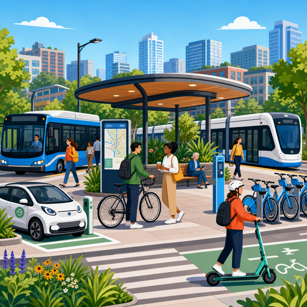
Mobility hubs are physical places where multiple transport services connect in one coordinated, user-friendly location, allowing people to move smoothly between walking, cycling, buses, rail, shared micromobility, ride-hail, and in some cases freight and delivery services. For transit agencies and city planners, the concept matters because hubs turn separate networks into one usable system. A bus stop, train station, bikeshare dock, curb zone, and wayfinding map may already exist on the same block, but without integrated design, management, and passenger information, they do not function as a true hub. In practice, a mobility hub combines infrastructure, operations, digital information, pricing logic, and public-space design to reduce friction across the first mile, main trip, and last mile.
In projects I have worked on, the difference between a transfer point and a successful mobility hub has always been coordination. Riders do not judge agencies by departmental boundaries; they judge whether the trip feels simple, safe, legible, and reliable. That is why mobility hubs have become central to sustainable urban development. They can increase transit ridership, support compact land use, reduce dependence on private cars, improve access to jobs and services, and make public investment more productive. They also help cities respond to changing travel behavior, including hybrid work, growth in cycling, demand-responsive transit, and the rapid expansion of shared vehicles and curbside activity.
The term mobility hub is sometimes used loosely, so clarity is important. A neighborhood hub may center on a bus interchange with secure bike parking and real-time information. A major regional hub may include metro, commuter rail, bus bays, accessible pick-up zones, taxi stands, charging infrastructure, public toilets, and retail. Some frameworks distinguish between destination hubs, community hubs, and gateway hubs. Others classify hubs by passenger volumes, modal mix, or catchment area. Regardless of scale, the core objective is the same: integrate modes around the user journey. That means universal accessibility, intuitive transfers, safe waiting areas, clear signage, and governance that matches how people actually travel.
For agencies and planners, mobility hubs are not a branding exercise. They are an implementation strategy that links transport planning, station design, curb management, land use policy, and operations. When done well, they improve both network performance and place quality. The sections below explain what a mobility hub includes, where it works best, how to plan and govern it, and which metrics show whether the investment is delivering results.
What a mobility hub includes and how it differs from a station
A station is primarily a boarding point for one service or mode. A mobility hub is a coordinated interchange environment designed around complete trips. The distinction matters because many underperforming sites already have high service levels but still lose riders through poor transfers. Typical hub components include connected platforms or stops, sidewalks built to accessibility standards, protected crossings, sheltered waiting areas, secure cycle parking, bikeshare or scooter parking, kiss-and-ride space where appropriate, managed loading zones, lighting, seating, public information displays, and digital trip planning support. Good hubs also include less glamorous but essential features such as drainage, maintenance access, snow storage planning, emergency call points, and clear operating rules for each service provider.
Successful hubs are designed from the curb inward and from the rider outward. That means resolving conflicts between buses, delivery vehicles, private pick-ups, paratransit, and micromobility before those conflicts degrade safety or reliability. London, Amsterdam, Vienna, and Singapore all offer strong examples of integrated interchange design, though each reflects different governance systems and street contexts. In North America, agencies have increasingly used hub pilots to retrofit suburban park-and-ride locations, major bus transfer centers, and rail stations with bike facilities, pickup management, and better wayfinding. The best results usually come when planners treat the site not as an isolated station parcel but as a district-scale access system that includes nearby intersections, sidewalks, and adjacent development.
Core planning principles for agencies and city planners
The first planning principle is to start with demand patterns rather than with a fixed menu of amenities. A hub serving hospital workers on night shifts needs different design choices than one serving university students or airport employees. Origin-destination data, transfer volumes, pedestrian desire lines, bicycle approach routes, dwell times, and accessibility audits should shape the concept. Automatic passenger counters, farecard taps, mobile location data, General Transit Feed Specification schedules, and curb occupancy studies can reveal where passengers lose time and where streetscape changes will produce the greatest benefit.
The second principle is to plan at multiple scales. At the network scale, agencies must decide which locations should function as anchors, feeders, and neighborhood connectors. At the site scale, planners need to minimize transfer distance, reduce level changes, and make routes obvious without requiring passengers to consult an app. At the district scale, land use should reinforce the hub with mixed uses, active frontages, and a street network that supports walking. This is where transit-oriented development and mobility hub planning overlap. A hub surrounded by blank walls, oversized parking lots, and unsafe arterials will underperform even if the platforms themselves are well designed.
The third principle is resilience. Hubs must work during service disruptions, extreme heat, heavy rain, snow, and power outages. Redundant passenger information channels, durable materials, shade, stormwater management, and contingency operating plans are not optional details. Climate adaptation increasingly belongs in hub design, especially where heat islands, flooding, or wildfire smoke affect daily travel.
Typical hub elements and their planning value
| Element | Purpose | Planning value |
|---|---|---|
| Real-time passenger information | Shows arrivals, disruptions, and platform changes | Reduces uncertainty and missed transfers |
| Secure bike parking | Supports first-mile and last-mile cycling | Expands the catchment area without more car parking |
| Managed curb zones | Organizes pick-up, drop-off, delivery, and paratransit | Improves safety and bus reliability |
| Accessible pathways | Provides step-free, legible movement for all users | Meets legal obligations and broadens ridership |
| Wayfinding and maps | Guides riders between services and nearby destinations | Shortens perceived transfer time |
| Shelters, seating, and lighting | Improves comfort and personal security | Raises customer satisfaction and dwell tolerance |
| Micromobility parking or docks | Accommodates bikes and scooters in an orderly way | Prevents sidewalk clutter and supports multimodal trips |
| Charging infrastructure | Serves e-buses, e-bikes, and fleet vehicles where relevant | Aligns the hub with vehicle electrification strategies |
Site selection, design, and curb management in practice
Choosing the right locations is more important than adding more locations. Strong candidates usually have high transfer volumes, underserved access conditions, nearby destinations, redevelopment potential, or strategic network importance. A suburban rail station with thousands of daily boardings may need a hub to shift access from private cars to buses, cycling, and walking. An urban bus transfer corridor may need one to reduce unsafe crossings and organize loading activity. Some cities also use smaller hubs in equity-priority neighborhoods where residents depend on transit but face weak pedestrian infrastructure or limited service coordination.
Design should prioritize the pedestrian path first. If riders must cross fast traffic, walk behind reversing vehicles, or navigate inconsistent signage, the hub will fail regardless of how many amenities it offers. The best sites provide direct crossings, sightlines between services, and simple hierarchy in materials and signage. Tactile paving, audible signals, platform edge treatments, and consistent vertical circulation are essential for accessible design. Agencies should apply standards from the Americans with Disabilities Act, local street design manuals, and recognized wayfinding practice rather than improvising each site.
Curb management is often the hidden determinant of success. I have seen otherwise strong hub projects undermined by ride-hail queues blocking bus stops, delivery vehicles occupying accessible loading areas, and uncontrolled scooter parking narrowing footways. Curb regulations must be mapped, signed, enforced, and updated as demand changes. Many agencies now pair physical redesign with digital curb inventory tools, camera-based occupancy monitoring, and permit systems for commercial loading. The objective is not to eliminate every competing use but to assign space according to public priorities: transit throughput, safety, accessibility, and efficient turnover.
Governance, funding, and operations
Most mobility hubs fail on governance before they fail on design. A hub may involve a transit operator, city transportation department, planning agency, public works, parking authority, private mobility providers, regional rail entity, business improvement district, and adjacent landowners. Without a clear operating model, maintenance gaps appear quickly. Someone must own customer information, snow clearance, cleaning, security coordination, curb enforcement, and data sharing. Memoranda of understanding can work for pilot projects, but permanent hubs usually need formal roles, service level agreements, and an identified budget for life-cycle maintenance.
Funding commonly comes from a mix of capital grants, local transportation funds, development contributions, and in some cases value capture tied to adjacent land development. In the United States, federal sources may include programs linked to transit, congestion reduction, accessibility, or emissions goals. In Europe and Canada, hub funding is often bundled with station renewal, public realm upgrades, or climate programs. The smartest funding packages connect capital spending with measurable operating savings or ridership gains. For example, better bus circulation can reduce layover conflicts and travel time variability, while improved walking and cycling access can defer expensive structured parking expansions.
Operations should be planned before construction documents are finished. Agencies need protocols for incident response, temporary stop relocation, platform assignment changes, vendor access, and communication during disruptions. Hubs with multiple operators should use common passenger information standards and clear escalation paths. If a station ambassador, security presence, or customer service desk is part of the concept, that staffing model must be funded for the long term, not only for launch month.
Measuring performance and avoiding common mistakes
Mobility hub performance should be measured with outcomes, not just amenities installed. The most useful metrics include transfer time, on-time performance at the hub, boarding growth, bicycle access share, paratransit usability, customer satisfaction, crash reduction, and curb compliance. Agencies should also track whether the hub improves access to jobs, education, healthcare, and daily services within reasonable travel times. Equity analysis matters because a visually upgraded hub can still fail lower-income riders if fares remain fragmented, elevators are unreliable, or safe access streets are missing beyond the station frontage.
Common mistakes are consistent across cities. One is oversupplying car access while undersupplying walking space. Another is treating micromobility as an afterthought, which leads to clutter and conflict. A third is failing to coordinate branding, maps, and digital information so riders experience the hub as a coherent system. Planners also underestimate maintenance. Broken elevators, dead displays, poor lighting, and dirty shelters quickly erase trust. Finally, some projects overbuild signature architecture while neglecting operational basics such as bus turning geometry, platform capacity, and weather protection. Users notice reliability first and aesthetics second.
For transit agencies and city planners, mobility hubs are a practical tool for making sustainable urban development real at street level. They connect modes, simplify transfers, strengthen transit-oriented places, and widen access without assuming every trip will begin in a private car. The strongest hubs are not defined by size or by expensive architecture. They are defined by integration: safe approaches, clear information, accessible design, disciplined curb management, and governance that keeps the site working every day.
The key takeaway is straightforward. If a city wants higher transit use, lower emissions, and better access to opportunity, it should invest in the points where journeys connect. Start with high-friction transfer locations, use data to identify the biggest barriers, design for pedestrians and accessibility first, and assign operational responsibility before construction starts. Then measure outcomes such as transfer time, reliability, and access, not just ribbon-cutting outputs.
Agencies that approach mobility hubs this way create more than improved stations. They create a network that feels connected to the public, easier to navigate, and more resilient as travel patterns evolve. Review your transfer hotspots, prioritize one pilot with strong demand and visible access problems, and build a hub strategy that links transportation, land use, and public space into one coherent plan.
Frequently Asked Questions
What is a mobility hub, and how is it different from a regular transit stop or station?
A mobility hub is a deliberately planned place where multiple transportation options are connected in a coordinated, easy-to-use environment. Unlike a standard bus stop or rail station that primarily serves one mode, a mobility hub is designed to help people transfer smoothly between walking, cycling, buses, rail, shared bikes or scooters, ride-hail, paratransit, and sometimes freight, pickup and drop-off, or delivery services. The key difference is integration. A mobility hub is not just several services located near one another; it is organized so that the user experiences them as one system rather than a series of disconnected pieces.
For transit agencies and city planners, that distinction is important. A bus stop, train platform, bikeshare dock, curb space, and wayfinding map might all exist on the same block, but if they are poorly signed, physically separated, inaccessible, or managed by different entities with no coordination, the location will still feel fragmented. A true mobility hub aligns physical design, operations, information, and curb management to reduce friction. Features often include safe pedestrian access, secure bike parking, universal design, visible signage, real-time information, sheltered waiting areas, designated pickup and drop-off zones, and space planning that makes transfers intuitive.
In practical terms, mobility hubs help convert independent networks into a connected mobility ecosystem. That improves the usefulness of transit, expands first-mile and last-mile options, and creates a more legible transportation experience for residents, commuters, and visitors. In other words, the hub itself becomes a piece of infrastructure that supports mode choice, improves access, and helps cities get more value from the services they already operate.
Why are mobility hubs becoming such a priority for transit agencies and city planners?
Mobility hubs have become a priority because transportation challenges increasingly occur at the points where systems meet. Many cities already have transit routes, sidewalks, bike lanes, and curb activity, but the user experience often breaks down during transfers. People may be willing to take transit if they can comfortably walk to a stop, store a bicycle safely, transfer quickly, and complete the final leg of the trip without confusion or delay. Mobility hubs address that exact problem by improving connectivity, convenience, and reliability across modes.
They also support broader policy goals. For transit agencies, better transfer environments can increase ridership by making the full trip more attractive, not just the in-vehicle segment. For city planners, hubs can advance climate, equity, safety, and land use objectives at the same time. Concentrating transportation services in strategic locations can reduce dependence on private cars, support transit-oriented development, improve access to jobs and services, and create safer public spaces through clearer circulation and better street design. In many communities, mobility hubs are also a practical response to competition for curb space and growing demand from micromobility, ride-hail, deliveries, and accessible transportation services.
Another reason they matter is that they create a framework for interagency coordination. Transportation services are often planned and managed by separate departments or operators, including transit agencies, public works, parking authorities, private mobility providers, and regional planning organizations. A mobility hub strategy gives those stakeholders a common place-based approach for deciding how space should function, which services belong there, and how users should move through it. That makes hubs valuable not only as physical investments, but also as governance and service integration tools.
What features make a mobility hub successful in real-world planning and operations?
A successful mobility hub combines physical design, service coordination, and user experience. At the most basic level, it must be easy to find, safe to access, and simple to understand. That starts with strong pedestrian infrastructure such as continuous sidewalks, visible crossings, ADA-compliant paths of travel, lighting, and traffic-calming elements where needed. If walking to and through the hub feels unsafe or confusing, the hub will not perform well no matter how many services are present.
Mode integration is the next essential feature. Transit stops or stations should be arranged so that transfers are short, direct, and sheltered where possible. Bike parking, bikeshare, scooter parking, pickup and drop-off areas, paratransit access, and designated curb uses should be placed intentionally rather than added wherever space happens to be available. Good hubs reduce conflict between users by clarifying where each activity belongs. They also provide information that supports decision-making, including maps, branding, multilingual signage, real-time transit displays, and digital trip-planning connections when appropriate.
Operational quality matters just as much as physical layout. A hub should have clear rules for curb management, maintenance responsibilities, and service allocation. If scooters block sidewalks, ride-hail vehicles stop in bus zones, or wayfinding falls out of date, the user experience deteriorates quickly. The most effective hubs are actively managed places, not one-time construction projects. Many also include amenities such as seating, shade, weather protection, charging, restrooms, retail, or community-serving uses depending on location and scale. Ultimately, successful mobility hubs are designed around how people actually transfer and wait, not around how agencies are organized on paper.
How should agencies and planners decide where mobility hubs should be located?
Location decisions should begin with travel demand and network value, not just available space. The best mobility hub sites are places where multiple services already intersect or where strategic investment could unlock major access benefits. That often includes major transit stations, bus transfer centers, downtown corridors, neighborhood commercial districts, university areas, hospitals, airports, suburban park-and-ride locations, and redevelopment zones. The central question is whether the site can function as a connector that helps many different users complete multimodal trips more efficiently.
Agencies and planners should evaluate both existing conditions and future potential. Useful indicators include transfer volumes, ridership, pedestrian activity, proximity to key destinations, current safety conditions, equity needs, land use intensity, and gaps in first-mile and last-mile connectivity. It is also important to consider whether the site can physically support hub functions through available right-of-way, curb flexibility, adjacent land uses, and opportunities for redesign. Some locations are ideal because they already attract riders; others are important because they currently underserve communities that would benefit from better access to mobility options.
Equity should be a core part of site selection. Mobility hubs should not be limited to high-profile downtown areas or development districts. They can be especially valuable in neighborhoods where residents depend on transit, where car ownership rates are lower, or where long and difficult transfers create barriers to opportunity. A tiered strategy often works well, with major regional hubs, smaller neighborhood hubs, and corridor-based transfer points all playing different roles within the same network. This allows agencies to prioritize investment while building a coherent system rather than treating each location as a stand-alone project.
What are the biggest implementation challenges, and how can agencies overcome them?
The biggest challenges are usually not conceptual but institutional and operational. Many mobility hub elements fall under different owners and managers. A transit agency may control platforms and shelters, while the city controls sidewalks and curb space, a private operator manages bikeshare, and a regional partner oversees wayfinding standards or funding programs. Without coordination, even well-designed hubs can become patchwork environments. Establishing shared goals, roles, and decision-making structures early is one of the most important steps in successful implementation.
Funding is another common barrier. Mobility hubs often involve a mix of capital improvements, technology, maintenance, staffing, and service agreements rather than a single construction line item. Agencies can address this by phasing projects, starting with lower-cost improvements such as signage, curb designation, paint, modular platforms, and bike parking before moving to larger station-area upgrades. Demonstration projects can also help build support and reveal operational issues before major investments are made. The strongest business case often comes from showing how hubs improve existing transit performance, support safety goals, and make better use of limited public space.
There is also the challenge of long-term management. A mobility hub is only successful if it remains legible, clean, safe, and responsive to changing travel patterns. That requires performance measures such as transfer times, user satisfaction, curb compliance, accessibility outcomes, ridership effects, and mode connections. Agencies should treat hubs as managed mobility assets, with regular review of service mix, signage, maintenance standards, and curb regulations. When governance, funding, and operations are addressed together, mobility hubs move from being an attractive planning idea to a reliable part of the transportation system.