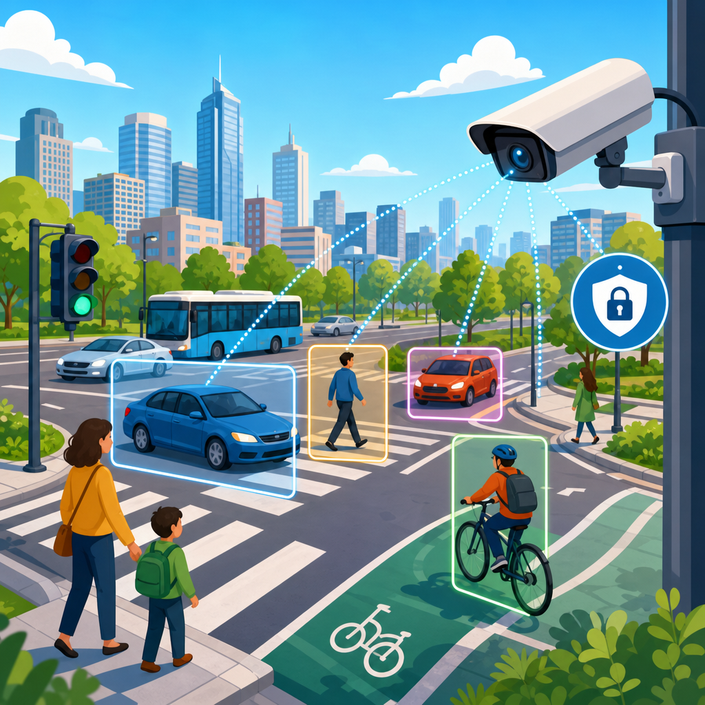
How cities use computer vision for traffic safety without violating privacy is no longer a speculative policy question. It is an operational issue for transportation departments, police agencies, public works teams, and planners trying to reduce deaths while respecting civil liberties. Computer vision, in this context, means software that interprets video from roadside cameras, transit corridors, intersections, or temporary sensors to identify patterns such as speeding, red-light running, near misses, blocked crosswalks, wrong-way driving, and pedestrian volumes. Privacy, here, means limiting the collection, retention, sharing, and identifiability of personal data so a safety system does not become a surveillance system. That distinction matters because cities increasingly pursue Vision Zero goals, yet residents rightly resist technologies that can track individuals, store license plates indefinitely, or expand law enforcement visibility without oversight.
I have worked with municipal analytics teams evaluating curb cameras, intersection video, and safety dashboards, and the practical lesson is straightforward: the camera is not the policy. A city can deploy the same hardware in two very different ways. One approach records high-resolution footage for long periods, allows broad access, and creates avoidable privacy risk. The better approach processes footage at the edge, converts video into anonymous counts or event metadata, masks faces and plates, restricts retention, and uses results to redesign streets, optimize signal timing, and target proven countermeasures. When officials explain those design choices clearly, public acceptance improves because residents can see the public benefit and the safeguards together.
This topic matters well beyond transportation engineering. Safer intersections affect housing markets, retail vitality, school access, transit reliability, insurance costs, and neighborhood trust. Streets with fewer crashes are more attractive to homebuyers and renters, and corridors that feel safe for walking tend to support stronger local commercial activity. As cities modernize infrastructure, the challenge is not whether computer vision can identify dangerous patterns; it can. The real question is how to obtain actionable traffic safety insights without collecting more personal information than necessary. The answer lies in careful system design, legal guardrails, and transparent governance.
What computer vision does for traffic safety
Computer vision systems for traffic safety detect and classify objects such as cars, buses, bicycles, scooters, and pedestrians across sequential video frames. They estimate trajectories, speeds, lane positions, turning movements, queue lengths, and conflict points where collisions nearly occur. Unlike traditional loop detectors buried in pavement, video analytics can see the full interaction among all road users, including vulnerable users who are usually undercounted. That richer picture helps cities move from reactive crash analysis, which depends on police reports after harm occurs, to proactive risk analysis that flags dangerous behavior before a serious injury or fatality happens.
A good example is near-miss analysis at intersections. Crash records alone are sparse and lagging indicators; a single junction may have few reported crashes in a year but hundreds of hard braking events, pedestrian yielding failures, or red-light entries that reveal elevated risk. Computer vision tools from vendors such as Miovision, Numina, Vivacity, and Hayden AI can quantify those events, often by using surrogate safety measures like post-encroachment time and time to collision. Transportation engineers then compare conditions before and after changes such as daylighting corners, adding leading pedestrian intervals, tightening curb radii, installing protected turn phases, or adjusting signal timing.
Another common application is bus lane and bike lane management. Cities use vision systems to detect double parking, delivery vehicle encroachment, blocked crosswalks, and unauthorized stopping in transit lanes. That data supports faster buses and safer cycling without needing continuous human review of footage. When systems count events rather than identify people, officials can answer practical questions directly: Which corridors have the highest frequency of bus lane obstruction? At what hours do delivery conflicts peak? Which school zones show repeated dangerous turning behavior during drop-off? Those answers let agencies deploy traffic officers, signage, paint, bollards, or curb regulations where they will have measurable effect.
How privacy-preserving design actually works
Privacy protection is not a marketing label; it is a set of technical and administrative controls. The strongest model starts with data minimization. If the safety objective is counting turning vehicles or measuring yielding compliance, the city does not need to store identifiable video. Edge processing is the first major safeguard. Instead of sending raw video to a central cloud, software on the camera or nearby device analyzes frames locally and exports only aggregated counts, anonymized trajectories, or event flags. In practice, that means the system may retain “15 pedestrians crossed during the signal cycle” rather than the image of each person.
Masking and redaction are the next layer. Modern systems can blur or irreversibly obscure faces and license plates before any storage or human access occurs. Some platforms avoid plate or facial extraction entirely, which is preferable because data not collected cannot be misused later. Short retention limits are equally important. I generally advise cities to separate diagnostic footage used for calibration from routine production data. Calibration clips may be kept for days under strict access control; routine analytics outputs can be retained longer because they no longer identify individuals. Public agencies should also document role-based access, audit logs, vendor restrictions, and deletion schedules in plain language.
Purpose limitation matters as much as the technology. A privacy-protective traffic safety program states that footage and derived data are used for safety engineering, signal operations, transit performance, and maintenance, not generalized surveillance. If law enforcement access exists, it should be narrowly defined, legally reviewed, and publicly disclosed. Many cities now require data protection impact assessments, procurement clauses barring secondary data sales, and independent security review aligned with standards from NIST and ISO 27001 practices. These controls do not eliminate every risk, but they materially reduce the chance that a safety initiative drifts into broad monitoring of residents.
Where cities gain the most safety value
The highest-value deployments focus on locations where conventional data is weakest and harm is greatest. School zones are a strong example. Video analytics can reveal speeding patterns by hour, illegal U-turns near crossing guards, and parent drop-off behaviors that create sightline conflicts. With that evidence, cities can change curb management, add raised crosswalks, extend no-parking areas near corners, or retime flashers. Senior centers, transit hubs, and multilane arterials also benefit because pedestrian exposure is high and crash severity rises quickly with vehicle speed. The Federal Highway Administration has repeatedly emphasized speed management as a central determinant of injury severity, making accurate behavioral data especially valuable.
Construction zones are another productive use case. Temporary lane shifts and unclear signage often produce confusion that standard counters miss. A mobile vision unit can measure late merges, encroachments into worker space, and sudden braking hotspots, helping agencies modify taper lengths or sign placement quickly. For curbside management, vision analytics help cities understand how ride-hail pickups, parcel delivery, food delivery, and personal vehicle loading interact. I have seen corridors where planners assumed congestion stemmed from signal timing, but video review showed the larger issue was repeated second-lane stopping for short pickups. Reassigning curb space and enforcing loading windows solved more than retiming alone.
Vision systems also support equity when deployed carefully. Historically, dangerous conditions in lower-income neighborhoods were undermeasured because resources for manual counts and detailed studies were limited. Automated, privacy-preserving analytics can provide a more consistent citywide baseline, helping agencies prioritize upgrades based on risk rather than political visibility. Equity is not automatic, though. Cities must publish selection criteria, validate models across lighting and weather conditions, and ensure that neighborhoods do not receive disproportionate monitoring without proportional safety investment. The legitimate public case for these systems is safer streets, not unequal scrutiny.
What a responsible city policy should include
A city policy for computer vision traffic safety should answer five questions clearly: what data is collected, why it is collected, how long it is kept, who can access it, and how the public can challenge misuse. Procurement language is crucial because many privacy problems begin in vendor contracts. Agencies should require that vendors act as service providers, prohibit data resale, prohibit model training on municipal footage without permission, document encryption in transit and at rest, and support configurable retention controls. They should also require explainable outputs so staff understand how events like near misses or blocked crosswalks are defined.
Independent governance strengthens trust. A transportation department should not be the sole judge of its own data practices. Better models include review by privacy officers, legal counsel, information security teams, and, where available, community advisory boards. Published use policies should distinguish transportation analytics from automated enforcement. People often conflate the two, but they are not identical. A system that counts red-light running to justify a signal redesign differs materially from a system issuing citations. If a city intends to do both, it should say so explicitly and apply separate legal authority, retention rules, accuracy standards, and appeal processes.
Measurement and reporting should be part of the policy from day one. Without public metrics, privacy safeguards sound abstract and safety claims sound promotional. Cities should report installation locations, purpose statements, retention periods, access logs summarized by department, and outcome metrics such as changes in speeding, yielding compliance, transit delay, or injury crashes after interventions. When officials show that a corridor experienced fewer dangerous turning conflicts after adding a leading pedestrian interval, residents can judge whether the technology is delivering proportional public value. Transparency turns a contentious camera debate into an evidence-based infrastructure conversation.
| Policy element | Good practice | Why it protects privacy and safety |
|---|---|---|
| Data collection | Capture only what is needed for counts, conflicts, and operations | Reduces exposure of personal information while preserving actionable metrics |
| Processing method | Use edge analytics with anonymized outputs | Limits transfer and storage of raw identifiable video |
| Retention | Keep routine footage briefly; retain aggregated data longer | Supports analysis without building long-term surveillance archives |
| Access controls | Role-based permissions, audit logs, and written approval paths | Prevents casual browsing and creates accountability |
| Public oversight | Publish use policy, vendor terms, and outcome reports | Builds trust and allows residents to evaluate proportionality |
Limits, risks, and how cities should address them
Computer vision is useful, but it is not neutral and it is not infallible. Cameras can perform differently in low light, rain, snow, glare, and heavy occlusion. Object classification can struggle with unusual vehicles, adaptive mobility devices, or dense pedestrian crowds. A city that treats analytics outputs as perfect will make avoidable mistakes. The right practice is validation. Agencies should benchmark systems against manual counts, test multiple times of day and seasons, and document acceptable error thresholds by use case. Counting pedestrians for planning can tolerate more error than issuing automated citations, which require much stricter evidentiary standards and legal safeguards.
Function creep is the largest governance risk. A network installed to analyze turning conflicts can later tempt agencies to expand into general policing, immigration inquiries, or persistent vehicle tracking. The remedy is not vague reassurance; it is hard boundaries in ordinance, contract, and access control. I recommend explicit prohibitions on facial recognition, generalized identity search, and secondary use unrelated to transportation safety or operations unless separately authorized through public process. Cities should also maintain incident response plans for data breaches, because even anonymized systems rely on networks, credentials, and vendors that can fail if cybersecurity is neglected.
Public communication deserves more attention than it usually gets. Residents often hear “AI cameras” and assume the worst because agencies speak in procurement language instead of plain terms. The better explanation is concrete: this system counts speeding and near misses, blurs plates and faces, stores routine footage briefly, and helps us decide whether to add a protected turn phase or redesign a crosswalk. That level of specificity lowers legitimate anxiety without minimizing tradeoffs. If your city is evaluating these tools, ask to see the use policy, retention schedule, sample outputs, and independent oversight structure. Those documents reveal whether the program is designed for safety, or merely named that way.
The strongest path forward is disciplined adoption. Cities should start with clearly defined safety problems, pilot privacy-preserving analytics in high-risk locations, validate accuracy, publish results, and scale only where evidence supports the investment. Used that way, computer vision can help engineers detect danger earlier, direct scarce capital dollars more intelligently, and improve transit and street design without normalizing mass surveillance. The public benefit is real when the guardrails are real. For transportation leaders, the next step is simple: build the policy architecture first, then deploy the cameras to serve it.
Frequently Asked Questions
1. How can cities use computer vision to improve traffic safety without identifying individual people?
Cities can use computer vision in ways that focus on dangerous traffic behavior rather than personal identity. In practice, that means configuring systems to detect events and patterns such as speeding, red-light running, wrong-way driving, vehicles blocking crosswalks, unsafe turns, near misses, pedestrian conflicts, and bicycle interactions at intersections. The software analyzes movement, trajectories, timing, and object classifications instead of trying to determine who a specific driver, passenger, cyclist, or pedestrian is.
Privacy-protective deployments typically rely on techniques such as edge processing, which means the video is analyzed locally on the device or near the camera rather than being continuously transmitted and stored. Many systems can convert raw video into metadata almost immediately, such as counts, dwell times, conflict events, heat maps, or incident alerts. When designed well, the city does not need to keep identifiable footage to learn that one corridor has frequent red-light running at 5:30 p.m. or that a crosswalk has repeated near misses during school drop-off hours.
Another important safeguard is minimization. Cities can deliberately limit resolution, narrow the camera field of view, blur faces and license plates, and disable features like facial recognition entirely. The goal is to collect only what is necessary for a safety purpose and nothing more. For example, a transportation department may need to know that turning vehicles are repeatedly failing to yield to pedestrians, but it does not need a permanent archive of every person who crossed the street.
Used this way, computer vision becomes a safety analytics tool, not a people-tracking system. It helps agencies identify hazardous locations, measure the effect of engineering changes, prioritize investments, and respond faster to dangerous conditions while maintaining clear boundaries around surveillance and personal privacy.
2. What kinds of traffic safety problems can computer vision actually detect?
Computer vision can detect a surprisingly broad range of traffic safety issues, especially when cities want to move beyond simple crash counts. Traditional safety analysis often depends on police reports and crash records, which are valuable but incomplete because they only capture incidents after harm has already occurred. Computer vision helps cities identify leading indicators of risk before severe crashes happen.
For example, systems can detect speeding patterns by estimating vehicle movement through a corridor or intersection. They can flag red-light running, rolling stops, illegal turns, blocked bike lanes, crosswalk encroachment, bus lane violations, and vehicles traveling the wrong way on one-way streets or ramps. In pedestrian-heavy areas, they can identify failure-to-yield behavior, conflicts between turning vehicles and people in crosswalks, and situations where vulnerable road users are forced to alter their path suddenly to avoid being struck.
One of the most useful capabilities is near-miss detection. A near miss may never appear in official crash data, but it often reveals a serious design problem. If a particular intersection produces repeated abrupt braking, evasive swerving, or close interactions between cars and pedestrians, that is highly actionable information for planners and engineers. It can justify signal timing adjustments, curb extensions, daylighting, leading pedestrian intervals, protected turn phases, or redesigned lane geometry.
Computer vision can also support operations. Public works teams may use it to detect congestion spillback, queue lengths, vehicles blocking intersections, or recurring unsafe behavior in work zones. Transit agencies can analyze bus stop conflicts, turning movements near transit corridors, and delays caused by curb misuse. The key point is that the technology does more than count vehicles. It gives cities a richer, behavior-based picture of how streets function, which is exactly what agencies need when the objective is preventing injury and death.
3. What privacy safeguards should cities put in place before deploying computer vision systems?
Strong privacy protection starts with governance, not just technology. Before deployment, cities should define a specific public-interest purpose for the system, such as intersection safety analysis, near-miss detection, speed management, or work-zone monitoring. If the purpose is vague or overly broad, the system can drift into uses the public never agreed to. A clearly written use policy should spell out what the technology is allowed to do, what it is prohibited from doing, who can access outputs, and how long any data may be retained.
Data minimization is essential. Cities should collect the least amount of information necessary to achieve the safety objective. In many cases, that means using low-retention or no-retention architectures, processing footage at the edge, storing only anonymized metadata, masking faces and license plates, and restricting camera angles so they capture roadway interactions instead of private spaces. If raw footage is needed temporarily for system validation or incident review, retention periods should be short, justified, and enforced automatically.
Cities should also prohibit sensitive functions unless there is a separate legal and public approval process. That usually includes banning facial recognition, biometric identification, persistent individual tracking, and secondary uses unrelated to traffic safety. A transportation safety tool should not quietly become a general-purpose surveillance platform. Clear separation between transportation analytics and criminal investigation functions is often an important trust-building measure, especially in communities concerned about over-policing or misuse.
Transparency matters as much as the technical controls. Agencies should publish privacy impact assessments, vendor contracts, data flow diagrams, retention schedules, audit processes, and performance reports. Public notice should explain what data is collected, how it is processed, what is never collected, and how residents can raise concerns. Independent audits and periodic reviews help confirm that the technology is operating as promised. When cities combine purpose limitation, minimization, technical safeguards, legal controls, and public accountability, they are much more likely to earn trust while still getting meaningful safety benefits.
4. Is computer vision mainly for enforcement, or can it be used for planning and street design too?
Computer vision is often associated with enforcement because cameras naturally raise concerns about tickets and surveillance, but its most valuable use cases in many cities are operational and planning-oriented. Transportation departments can use it to understand why a location feels unsafe long before a fatal crash forces action. Instead of waiting for enough injuries to accumulate in official records, agencies can detect conflict patterns, risky turning movements, school-zone speeding trends, and unsafe curbside behavior early and intervene faster.
That makes the technology especially useful for street design. If computer vision shows repeated near misses between turning vehicles and pedestrians, the city may add a leading pedestrian interval, shorten crossing distances, install protected turn phases, or redesign corner geometry. If a corridor shows chronic speeding despite posted limits, planners might consider lane narrowing, raised crossings, speed cushions, curb extensions, or signal coordination changes. If bike lane incursions are common, engineers may evaluate curb protection, better loading management, or improved intersection treatments.
It is also valuable for measuring whether interventions work. After a city changes signal timing, installs a refuge island, modifies a bus stop, or redesigns a school-zone pickup area, computer vision can compare pre- and post-project conditions. That helps agencies move from intuition to evidence. They can demonstrate whether conflicts decreased, yielding improved, speeds dropped, or pedestrian comfort increased.
Enforcement may still be part of the broader traffic safety ecosystem in some jurisdictions, especially where automated enforcement is legally authorized. But even then, computer vision does not have to be enforcement-first to be useful. Many of the highest-value applications involve diagnosis, prioritization, design evaluation, maintenance response, and safety performance monitoring. When cities frame the technology as a tool to make streets safer by improving infrastructure and operations, rather than simply punishing violations, they tend to build stronger public support and achieve more durable safety outcomes.
5. How can cities make sure computer vision systems are accurate, fair, and accountable?
Accuracy and accountability require more than buying a capable vendor product. Cities need a structured validation process that tests whether the system performs reliably in the real world, under local conditions, and for the specific safety tasks it is supposed to support. That includes checking performance in daytime and nighttime conditions, rain, glare, seasonal changes, heavy traffic, work zones, and complex urban environments with pedestrians, cyclists, buses, and delivery vehicles. A system that performs well in a controlled demo may not be reliable enough for operational use without local testing.
Cities should define measurable standards for accuracy before deployment. For example, if the system claims to detect red-light running, near misses, or wrong-way driving, the agency should know the expected precision, recall, false positive rate, and false negative rate for each use case. These metrics matter because poor performance can lead to bad policy decisions. If a tool undercounts pedestrian conflicts, a city may overlook a dangerous location. If it overcounts violations, it may misallocate resources or undermine public trust.
Fairness is equally important. Agencies should assess whether the system performs consistently across different neighborhoods, lighting conditions, roadway types, and user groups. It should not work well only in affluent areas with clearer markings and newer infrastructure while underperforming in communities that already face higher safety risks. Accountability also means documenting human oversight. Computer vision outputs should inform decisions, but they should not be treated as infallible. Staff should be able to review findings, question anomalies, and verify major conclusions before policy or enforcement actions are taken.
Finally, accountability depends on procurement and oversight discipline. Vendor contracts should specify data ownership, privacy restrictions, audit rights, cybersecurity requirements, model update procedures, and remedies if performance claims are not