Urban flooding is no longer a rare disruption tied only to extreme storms. In many cities, it is a recurring infrastructure problem shaped by denser development, aging drainage networks, paved surfaces, and climate-driven rainfall intensity. IoT sensors are changing flood monitoring in cities by turning water systems from mostly invisible assets into measurable, responsive networks. Instead of relying on scattered manual inspections, delayed reports, or a few fixed gauges, city teams can now track water depth, pipe pressure, rainfall, pump status, and drain performance in near real time. That shift matters because minutes often determine whether a flooded street becomes a brief inconvenience or a costly emergency affecting homes, businesses, transit, and public safety.
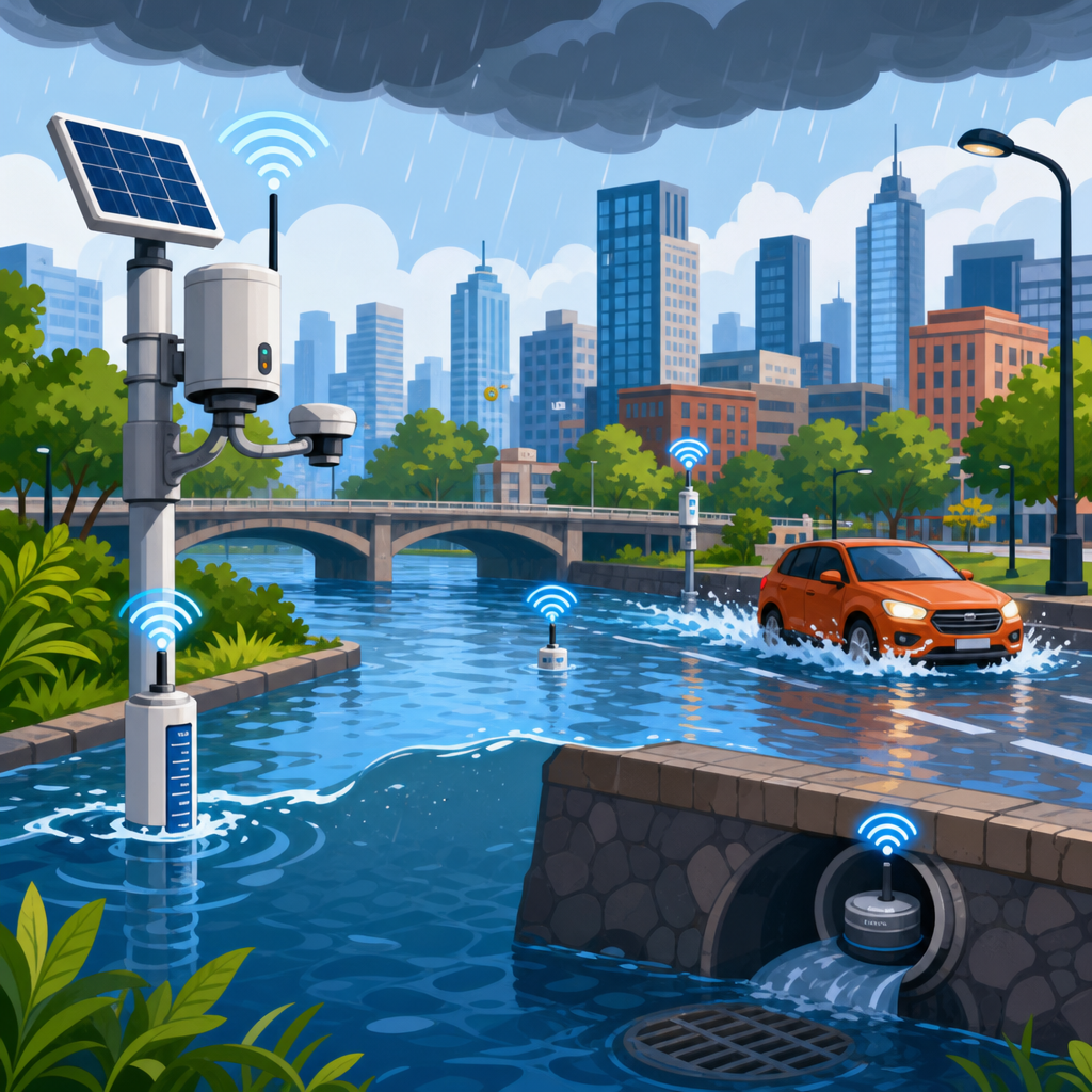
IoT stands for the Internet of Things, a system in which physical devices collect data and send it through communications networks to software platforms for analysis and alerts. In flood monitoring, those devices include ultrasonic level sensors above culverts, pressure transducers in pipes, rain gauges on rooftops, soil moisture probes in parks, and camera systems at known trouble spots. The data moves over cellular, LoRaWAN, NB-IoT, satellite, or municipal wireless networks into dashboards used by utilities, emergency managers, transportation departments, and sometimes the public. From my work with sensor deployments on municipal assets, the biggest difference is practical: crews stop guessing where water is rising and start seeing conditions block by block.
For city leaders, the value extends beyond emergency response. Better flood monitoring improves capital planning, insurance documentation, maintenance prioritization, and public communication. A housing market is affected as well, because repeated flooding changes buyer behavior, lender risk models, renovation costs, and neighborhood desirability. When cities can document drainage performance and identify chronic flood zones accurately, they make smarter investments and give residents more credible information. The result is not that sensors stop floods on their own. The result is that cities gain the evidence needed to reduce losses, target upgrades, and respond faster when storms hit.
What IoT flood monitoring looks like in practice
At a practical level, an IoT flood monitoring system combines field hardware, connectivity, analytics, and response workflows. Sensors measure a condition such as water level every few minutes or seconds. A gateway or onboard modem transmits that reading to a cloud or on-premises platform. Software applies thresholds, flags anomalies, plots trends, and triggers alerts by text, email, or dispatch integration. The city then acts: sending a crew to clear a blocked inlet, activating pumps, closing a road, or notifying residents in a low-lying area. The most effective systems are built around operational decisions, not just data collection.
Common devices include ultrasonic level sensors mounted above channels, radar level sensors used where condensation or debris interferes with sound waves, submersible pressure sensors in manholes and storm sewers, tipping-bucket rain gauges, and water quality sensors that help distinguish stormwater inflow from wastewater overflow events. Many cities also connect pump controllers, gate actuators, and backup power status into the same platform. In combined sewer systems, that integration is especially valuable because operators need to understand both flooding risk and overflow compliance. Utilities often pair this data with GIS layers, digital elevation models, and hydraulic models such as EPA SWMM or InfoWorks ICM.
The strongest deployments focus on high-consequence locations first. That usually means underpasses, creek crossings, undersized culverts, neighborhoods with basement backup history, and intersections where emergency access can be cut off by six to twelve inches of water. Cities such as Rotterdam, Singapore, and parts of Copenhagen have invested heavily in sensor-backed urban water management because dense development leaves little margin for failure during cloudbursts. In the United States, many local programs began with a few pilot sites after repeated nuisance flooding, then expanded once public works teams saw they could verify trouble spots and defend budget requests with actual measurements.
Why cities are investing now
Several forces are pushing flood monitoring up the municipal agenda. First, rainfall patterns are becoming less predictable, with more short-duration, high-intensity events overwhelming systems designed for older storm assumptions. Second, urbanization increases runoff because roofs, roads, and parking lots prevent water from soaking into soil. Third, residents expect faster communication and visible action when roads flood or basements back up. Fourth, cities are under pressure to justify infrastructure spending with measurable outcomes. IoT sensors help meet all four demands because they produce a time-stamped record of what happened, where, and for how long.
There is also a financial reason. Traditional flood studies can be expensive and episodic, while sensor networks create a continuous evidence base. If a city can prove that one catchment repeatedly reaches critical depth after moderate storms, it can prioritize a detention basin, upsized pipe, green infrastructure retrofit, or pump upgrade with more confidence. Insurers, lenders, and property owners increasingly look beyond broad FEMA flood maps, which may not capture localized pluvial flooding caused by overwhelmed drainage. Street-level data helps municipalities explain risk more accurately. That has implications for residential investment, redevelopment feasibility, and the long-term resilience of housing stock in vulnerable districts.
Another driver is technology maturity. Battery life has improved, low-power networks are more available, and sensor costs have fallen enough that medium-size cities can deploy meaningful coverage without building custom systems from scratch. Vendors now offer ruggedized hardware with ingress protection ratings suitable for wet environments, onboard diagnostics, and software APIs that connect to 311 systems, asset management tools, and emergency notification platforms. The conversation has shifted from whether sensor-based monitoring works to where it delivers the highest return first.
How sensor data improves forecasting, response, and maintenance
The immediate benefit of IoT flood monitoring is earlier warning. If water levels in an upstream culvert rise quickly while rainfall intensifies, software can alert staff before downstream roads flood. That lead time may be only ten or fifteen minutes, but in urban operations that can be enough to deploy barricades, reroute buses, or protect a pump station. Better still, when a city stores event data over months and years, it can train predictive models that estimate flood likelihood based on rainfall intensity, antecedent moisture, tide conditions, and current pipe levels. Forecasting becomes more localized than a regional weather alert.
Response quality also improves because teams can separate systemwide stress from asset failure. I have seen crews spend hours checking drains during storms when the real issue was a single blocked trash rack at a culvert entrance. With sensor traces, operators can compare upstream and downstream levels, identify sudden divergence, and dispatch directly to the likely obstruction. Cameras can confirm whether debris, not rainfall volume alone, caused the spike. That precision reduces overtime, shortens road closures, and prevents avoidable property damage.
Maintenance planning becomes far more disciplined with continuous monitoring. Instead of cleaning inlets and pipes on fixed schedules alone, public works departments can use threshold breaches and recurring slow-drain patterns to identify assets that need intervention. A sensor that shows repeated ponding after relatively small storms may reveal sediment buildup, root intrusion, collapsed pipe sections, or poor grading around an inlet. Over time, this supports condition-based maintenance, a method already standard in many industrial environments. Cities can then direct scarce crews and capital budgets to the assets causing the most operational risk.
| Monitoring use case | Typical sensor or data source | Operational benefit for cities |
|---|---|---|
| Road underpass flooding | Ultrasonic or radar water level sensor | Automatic road closure alerts and safer traffic management |
| Storm sewer surcharge | Pressure transducer in manhole or pipe | Early warning of backup risk and targeted crew dispatch |
| Localized cloudburst detection | Tipping-bucket rain gauge plus weather API | More accurate neighborhood-level forecasting |
| Pump station reliability | Pump status, power, and wet well sensors | Faster intervention before equipment failure causes flooding |
| Chronic drainage blockage | Repeated level spikes paired with camera review | Condition-based maintenance and better capital planning |
Where IoT sensors fit into resilient city planning
Flood monitoring works best when it is part of a broader resilience strategy rather than a standalone technology project. Sensor data should inform hydraulic modeling, emergency planning, zoning decisions, street design, and housing resilience programs. If a corridor floods repeatedly, the answer may be larger pipes, but it may also be curb redesign, permeable pavement, bioswales, upstream storage, or revised development controls that limit runoff. Sensors provide the evidence to compare those options. They show not only where flooding occurs, but also how interventions perform after installation.
This matters for housing because repeated urban flooding affects property values, rehabilitation costs, and mortgage decisions. Buyers increasingly ask whether a block floods even when it sits outside a mapped riverine floodplain. Sellers and developers are under pressure to disclose more than historic insurance claims. Municipal sensor data can support more honest conversations about site drainage, street ponding duration, and basement vulnerability. It can also justify resilience grants for backflow preventers, lot grading improvements, floodproofing, and green infrastructure in neighborhoods where the private market alone will not close the risk gap.
Well-run cities also use sensor findings to strengthen public trust. Instead of vague statements after a storm, officials can show rainfall totals, time-series water levels, pump runtimes, and the exact sequence of events. That transparency improves after-action reviews and helps residents understand why one street flooded while another did not. It also helps departments coordinate. Transportation, water utilities, planning, and emergency management often hold different pieces of the flood puzzle; IoT platforms pull them into one operational picture.
Challenges cities must solve before scaling
IoT flood monitoring is not plug-and-play. Sensors fail, batteries deplete, communications drop, and bad installation can produce misleading data. Urban environments are harsh: debris strikes, vandalism, condensation, corrosion, silt, and power interruptions are common. Any city deploying these systems needs calibration protocols, maintenance schedules, redundant communications where consequences are high, and clear ownership of the data stream. A dashboard no one watches during storms is not a monitoring strategy. Staffing and response procedures matter as much as hardware selection.
Data quality is the biggest make-or-break issue. Water level sensors mounted too high, pressure sensors without barometric compensation, or rain gauges placed near roof splash can create false confidence. The best programs validate field readings against manual observations, CCTV review, and post-storm inspections. They also define action thresholds carefully. An alert at the wrong level leads to alarm fatigue; an alert set too high arrives too late. Cybersecurity is another concern because connected infrastructure can expose municipal networks if not segmented and managed properly.
Cost remains a real constraint, though not usually because individual sensors are prohibitively expensive. The larger expense is total lifecycle management: installation, permits, software subscriptions, replacement cycles, integration, training, and ongoing field service. Cities that succeed usually start with a clear use case, prove value at a limited number of sites, then expand based on measured outcomes such as reduced response times or fewer repeat flooding complaints. That phased approach is more durable than buying a large platform before workflows and asset priorities are defined.
What the future of urban flood monitoring looks like
The next phase is convergence. IoT sensors will increasingly feed digital twins of drainage networks, combine with weather radar and satellite observations, and support automated control of pumps, gates, and storage assets. Machine learning will help identify patterns humans miss, such as the specific rainfall and tide combination that precedes flooding in a single district. Edge computing will allow some devices to process anomalies locally, reducing latency during fast-moving storms. At the same time, public-facing maps will become more dynamic, giving residents route warnings and hyperlocal flood risk updates based on live conditions rather than static assumptions.
For cities, the central lesson is straightforward: you cannot manage what you cannot see. IoT sensors are changing flood monitoring in cities because they turn hidden drainage behavior into operational intelligence. They help crews respond faster, planners invest smarter, and residents understand risk more clearly. They do not replace sound engineering, maintenance, or resilient land use policy, but they make all three more effective. If your city faces repeated street flooding, basement backups, or stormwater uncertainty, the next smart step is to identify the highest-risk locations, define the decisions that need better data, and build a sensor program around those priorities.
Frequently Asked Questions
1. How do IoT sensors improve flood monitoring in cities compared with traditional methods?
IoT sensors improve flood monitoring by giving city teams continuous, location-specific visibility into how water is moving through streets, drains, culverts, retention basins, rivers, and stormwater systems. Traditional monitoring often depends on manual inspections, public complaints, weather forecasts, and a limited number of fixed gauges. Those tools still matter, but they can leave major blind spots between inspection points and during fast-changing storm events. IoT networks help fill those gaps by collecting live data on water level, flow rate, pipe pressure, rainfall intensity, soil moisture, and in some cases pump or gate performance.
This changes flood monitoring from a reactive process into a more responsive and operational one. Instead of waiting for flooding to become visible at the surface, city staff can detect abnormal conditions earlier, such as a drain filling too quickly, a detention structure reaching capacity, or a low-lying corridor repeatedly showing rising water during moderate rain. That earlier awareness can support faster road closures, targeted field deployment, pump activation, maintenance checks, and more accurate public alerts. It also helps cities understand not just where flooding happens, but why it happens, which is essential for long-term planning and infrastructure upgrades.
2. What types of IoT sensors are used in urban flood monitoring systems?
Cities use several types of IoT sensors depending on the flood risks they face and the assets they need to monitor. Water level sensors are among the most common, and they are installed in storm drains, manholes, channels, rivers, underpasses, detention ponds, and other flood-prone locations. These sensors measure how high water is rising and can trigger alerts when levels approach defined thresholds. Flow sensors are also widely used to track how quickly water is moving through pipes or open channels, which can reveal blockages, capacity issues, or system stress during intense rainfall.
Rain gauges connected through IoT networks provide highly localized precipitation data, which is especially valuable in cities where one neighborhood may receive far heavier rainfall than another. Soil moisture sensors can help indicate whether ground conditions are already saturated, making runoff more likely even before a storm peaks. Some systems also include weather stations, pressure sensors, pump-status sensors, valve-position sensors, and cameras for visual confirmation. Together, these devices create a more complete picture of urban hydrology. Rather than treating flood monitoring as a single reading from a distant gauge, cities can build a layered network that reflects the complexity of real urban water behavior.
3. Can IoT flood sensors help cities respond to flooding in real time?
Yes, one of the biggest advantages of IoT-based flood monitoring is the ability to support near real-time response. When sensors transmit data continuously over cellular, radio, LPWAN, or other communications networks, city operations teams can monitor changing conditions as storms unfold rather than reconstructing events after the fact. If a water level sensor detects rapid rise at a known trouble spot, teams can issue alerts, dispatch field crews, redirect traffic, inspect nearby assets, or coordinate with emergency management before conditions become more severe.
Real-time data also improves decision-making because it reduces reliance on assumptions. Forecasts may predict heavy rain, but sensor feeds show what is actually happening on the ground and inside the drainage system. In advanced setups, sensor data can be integrated into dashboards, GIS platforms, control rooms, and automated alert systems so staff can see flooding risk by location and priority. Some cities also connect flood monitoring systems to smart infrastructure controls, such as pumps, gates, or retention systems, creating the possibility for semi-automated response. While sensors do not stop flooding on their own, they give cities the operational awareness needed to act faster, allocate resources more effectively, and reduce damage and disruption.
4. How do IoT sensors help cities plan long-term flood resilience projects?
IoT sensors are valuable not only during storms, but also in the months and years afterward because they generate the historical data cities need to make better infrastructure decisions. Many flood problems are repetitive but poorly documented. A neighborhood may experience roadway ponding several times each year, or a specific drainage line may back up during storms that are not especially extreme. Without reliable data, it is difficult to justify capital investment, prioritize projects, or prove that a drainage network is underperforming. Sensor records provide measurable evidence of how often flooding occurs, how long it lasts, how quickly water rises, and which assets are under the most stress.
That information can guide both engineering and policy decisions. Cities can identify recurring bottlenecks, compare actual system performance against design expectations, and determine whether issues stem from undersized pipes, blocked inlets, inadequate storage, land-use change, or more intense rainfall patterns. Sensor data can also strengthen flood models, improve asset management programs, and support grant applications by showing a documented need for intervention. Over time, this helps cities move from short-term fixes toward more strategic resilience investments, such as drainage upgrades, green infrastructure, detention expansion, pump improvements, and better protection for vulnerable corridors and communities.
5. What are the main challenges cities face when deploying IoT sensors for flood monitoring?
Although the benefits are significant, successful deployment requires more than just installing devices. One major challenge is placing sensors in the right locations. Cities need to understand their drainage networks, recurring flood points, maintenance constraints, and communications coverage so the network captures meaningful data rather than producing isolated readings with limited operational value. Hardware durability is another concern because flood monitoring devices often operate in harsh environments with debris, sediment, corrosion, vibration, and intermittent submersion. Sensors must be rugged enough to function reliably through repeated storm events.
Data quality and system integration are also critical. A city may collect large volumes of sensor data, but if that data is not calibrated, validated, and connected to usable dashboards or workflows, it can overwhelm staff rather than help them. Power supply, battery life, ongoing maintenance, communications reliability, and cybersecurity all need attention as well. Just as important, cities need a clear response framework for what happens when thresholds are crossed. In practice, the most effective programs combine strong device selection, thoughtful network design, regular maintenance, staff training, and integration with emergency operations and public works processes. When those elements are in place, IoT flood monitoring becomes much more than a technology project; it becomes part of how a city manages risk, protects infrastructure, and serves residents more effectively.