Last-mile freight infrastructure for denser neighborhoods is the network of physical assets, curb rules, buildings, data systems, and operating practices that moves goods from a local distribution point to homes, shops, offices, and institutions within compact urban areas. In planning terms, “last mile” is not literally one mile. It is the final urban segment where deliveries interact with sidewalks, loading zones, bike lanes, transit stops, alleys, and building entries. “Denser neighborhoods” generally means places with high residential or employment concentration, limited curb space, mixed land uses, and heavy competition among freight, transit, walking, and public realm functions. This topic matters because e-commerce growth, grocery delivery, restaurant logistics, medical shipments, and reverse logistics have increased the number of daily stops per block, while many neighborhoods still rely on street designs and zoning assumptions built for lower delivery intensity.
I have worked on curb management and development review for infill districts, and the pattern is consistent: when freight infrastructure is missing, every other street goal suffers. Double-parking blocks buses, delivery vans idle in bike lanes, package carts crowd narrow sidewalks, and building staff improvise storage in lobbies never designed for sustained parcel volume. Residents notice the symptoms before they know the cause. They see congestion, noise, safety conflicts, and missed deliveries. Small businesses face stock delays and higher operating costs. Carriers absorb route inefficiency, penalties, and driver stress. For city governments, the issue reaches beyond convenience. Last-mile freight affects climate targets, Vision Zero commitments, commercial vitality, and housing quality. A dense neighborhood that plans for people but ignores goods movement is not fully planned.
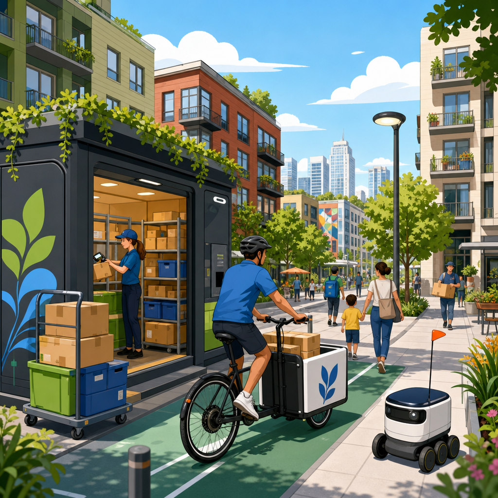
The good news is that last-mile freight infrastructure is not one project. It is a coordinated set of decisions at several scales. At the metropolitan edge, urban consolidation centers and microhubs influence vehicle size and trip timing. At the district scale, curb pricing, loading strategies, and delivery windows shape how vehicles circulate. At the building scale, package rooms, service elevators, lockers, and off-street loading determine whether the street can function efficiently. At the operational scale, route optimization software, digital curb permits, and common carrier access rules improve throughput without adding lane width. The core planning challenge is to match freight demand to neighborhood form. Dense places require smaller vehicles, shorter dwell times, more disciplined curb allocation, and building standards that recognize packages and service deliveries as basic urban utilities, not afterthoughts.
Why dense neighborhoods create unique freight pressure
Dense neighborhoods intensify delivery demand because more destinations fit within fewer blocks, but access becomes harder as street space grows scarcer. A suburban shopping center may have abundant loading docks, surface parking, and back-of-house circulation. A mixed-use corridor in a city may have retail tenants with no rear loading access, apartments above with hundreds of weekly parcel deliveries, and curbs already assigned to buses, ride-hailing, accessible parking, parklets, bike corrals, and passenger pickup. Freight activity concentrates at the exact points where urban design seeks the highest pedestrian comfort. That is why standard logistics efficiency metrics, such as travel speed alone, are inadequate. The critical metrics in compact districts are stop productivity, dwell compliance, failed-delivery rate, loading turnover, and conflict frequency with vulnerable road users.
Several market trends sharpen that pressure. Consumers increasingly expect narrow delivery windows, same-day service, and free returns. Retailers carry less backroom inventory and rely on frequent replenishment. Grocery and meal delivery add time-sensitive trips, often peaking in evening periods when curb demand is already high. Multifamily housing generates parcel volumes far above what older building codes anticipated. In many buildings, leasing staff have become informal warehouse managers. The result is a freight landscape with more stops, smaller loads, and tighter service expectations. Planners should treat this not as a temporary response to online shopping, but as a durable shift in urban goods movement. Dense neighborhoods need infrastructure designed for high-frequency, low-footprint logistics.
The core components of last-mile freight infrastructure
The most effective systems combine physical design, policy, and operations. Physical infrastructure includes loading bays, alley improvements, parcel lockers, curbside loading zones, freight elevators, secure bicycle parking for cargo bikes, and microhubs located in garages, underused retail bays, or municipal lots. Policy infrastructure includes zoning standards, curb regulations, pricing, delivery time windows, and access permits. Operational infrastructure includes booking platforms for loading zones, carrier coordination protocols, package room management systems, and enforcement practices. If one layer is missing, the others underperform. For example, a building may include a loading dock, but if truck access requires an unsafe turning movement or the dock lacks vertical clearance, drivers will still use the curb. Similarly, a curb loading zone without active enforcement quickly becomes general parking.
In practice, cities should think in terms of a freight chain rather than isolated assets. A package may arrive by medium truck to a neighborhood microhub, transfer to an electric cargo bike, enter a building through a service entrance, move by elevator to a package room, and be claimed later through a digital notification. Every link matters. Weak links create spillover onto public space. I have seen modern apartment projects with attractive streetscapes but no realistic parcel storage plan; within months, the lobby became congested and deliveries spilled onto the sidewalk. I have also seen ordinary mixed-use projects perform well because the freight path was mapped from curb to tenant door during design review. Good last-mile infrastructure is usually less about expensive technology than about disciplined interface design.
Curb management is the frontline system
The curb is the most contested piece of freight infrastructure in dense neighborhoods, and it is often managed with outdated assumptions. Traditionally, cities assigned loading zones based on complaints or left freight to compete informally with parking. That approach fails where delivery intensity is high. Modern curb management starts with inventory: mapping every curb segment, regulation, turnover pattern, and adjacent land use. Cities such as Washington, DC, and Seattle have used curb data programs to identify where commercial loading demand is strongest and where regulations conflict with actual use. The next step is allocation. Freight zones should be placed near buildings with high shipment volume, designed for realistic vehicle lengths, and scheduled around peak pedestrian and transit activity.
Pricing and enforcement are essential. Underpriced or free curb space encourages long dwell times and non-freight misuse. Demand-based pricing, digital permits, and camera-supported enforcement increase turnover and reliability. Reliability matters more to carriers than nominal access. A guaranteed legal space for ten minutes is more valuable than a theoretically available curb lane that is usually occupied. Cities should also distinguish among vehicle types. Parcel vans, box trucks, food delivery riders, and service vehicles have different dwell patterns and loading needs. A one-size loading zone rarely works. Some corridors need short-stay bays for parcel vans, while others need morning loading windows for retail replenishment and midday conversion to passenger use. Dynamic curb rules, clearly signed and digitally published, can serve multiple users without constant conflict.
Building design standards determine street performance
Many freight problems that appear to be traffic issues actually begin in building design. If a dense residential or mixed-use building lacks a package room sized to actual parcel volume, drivers make repeated attempts, staff hand-sort deliveries in common areas, and residents crowd entrances. If a commercial building has no service corridor, carts move through the primary lobby. If a loading bay is too small, too steep, or blocked by private parking, trucks remain curbside. Cities should update development standards to require freight planning proportional to building intensity. That means parcel room area standards, secure locker integration, off-street loading where feasible, protected service access, and vertical circulation sized for carts and pallet jacks, not just passengers.
Developers often resist prescriptive requirements, and there are legitimate tradeoffs. Not every site can accommodate a full dock, especially on small infill parcels. However, flexibility should not mean omission. Performance-based standards can work better than rigid dimensional rules. A project might satisfy requirements through shared loading access, scheduled use of an alley, participation in a nearby microhub, or a transportation demand management plan for deliveries. The key is to require a goods movement strategy during entitlement, just as many cities already require traffic studies, bicycle parking plans, or waste management plans. Freight should be reviewed as an operating system. Once a building opens, correcting undersized service areas is far more expensive than planning them from the start.
Microhubs, cargo bikes, and smaller vehicles
Microhubs are localized transfer points where goods shift from larger inbound vehicles to smaller, neighborhood-compatible modes. In dense districts, they can reduce van miles, shorten dwell times, and support zero-emission delivery. A microhub might occupy a repurposed ground-floor bay, a section of a public garage, or a modular container on municipally controlled land. From there, operators dispatch cargo bikes, hand carts, or compact electric vehicles for final delivery. European cities have advanced this model for years. In Paris, London, and Hamburg, logistics operators use urban depots to serve central neighborhoods with lower-emission fleets and fewer curb conflicts. The concept also fits North American districts, especially where building density is high and truck access is constrained.
Cargo bikes are not a universal replacement for vans, but they are highly effective for parcels, meals, groceries, pharmacy items, and small business restocking within short radii. Their success depends on infrastructure beyond bike lanes alone: secure staging space, curb access for loading, charging support for e-bikes, and building entries that accommodate larger cycle dimensions. Planners should also understand payload and weather limits. Heavy construction materials or bulk retail loads still require trucks. The best systems use mode matching. Trucks bring volume to the neighborhood edge; cargo bikes handle the fine-grained distribution pattern within it. That arrangement reduces curb pressure while maintaining service reliability, especially in areas with chronic congestion or restricted loading access.
| Infrastructure tool | Primary function | Best use case in dense neighborhoods | Main limitation |
|---|---|---|---|
| Curb loading zone | Short-term legal loading access | Retail corridors and mixed-use streets with high stop turnover | Fails without enforcement and pricing |
| Off-street loading bay | Keeps larger vehicles out of travel lanes | Large residential, office, hospital, and hotel projects | Often infeasible on small infill parcels |
| Package room or lockers | Secure receiving and resident pickup | Multifamily buildings with high parcel volume | Needs active management and adequate sizing |
| Microhub | Transfers goods to smaller delivery modes | Districts with truck constraints and high parcel density | Requires land, operator coordination, and steady throughput |
| Cargo bike staging | Supports low-emission final delivery | Short-distance routes in congested central areas | Limited payload compared with vans |
Policy, data, and governance make infrastructure usable
Physical upgrades alone will not solve last-mile problems if governance remains fragmented. Freight touches transportation departments, planning agencies, economic development teams, sanitation services, police enforcement units, and private property owners. Successful programs usually establish a clear lead agency and a freight data framework. At minimum, cities need baseline information on delivery volumes, curb occupancy, violations, dwell time by vehicle type, and building-generated package demand. Tools such as curb sensors, license-plate transaction data, camera observation, and carrier interviews can help, but simple field audits still matter. In my experience, direct observation during morning replenishment and evening parcel peaks reveals operational failures that datasets alone miss.
Governance also means creating rules that operators can follow consistently. Digital curb reservation systems can work if they are easy to use and supported by enforcement. Delivery windows can reduce conflicts near schools or transit hubs, but they must align with building staffing and resident access patterns. Zero-emission zones can accelerate cleaner fleets, yet they require charging infrastructure and realistic transition timelines for carriers. Procurement policy matters as well. Cities that manage libraries, clinics, schools, and maintenance yards can consolidate their own deliveries and model better practice. The most durable freight programs treat operators as partners without surrendering public goals. Carriers understand route economics in detail; planners understand street tradeoffs. The strongest policies are built from both perspectives.
How cities and developers should act now
A practical action agenda starts with diagnosis, not ideology. First, map freight generators: apartment buildings, grocery stores, restaurants, clinics, schools, and small-format retailers. Second, inventory curb regulations and identify mismatch between legal loading supply and actual demand. Third, update development review checklists so major projects submit parcel management, service access, and loading plans. Fourth, pilot targeted interventions on a few blocks: convert underused parking to loading, add digital permits, create a microhub, or designate cargo bike staging. Fifth, measure results using dwell compliance, bus delay, sidewalk obstruction incidents, delivery success rate, and merchant feedback. Pilot programs work best when they are specific, timed, and evaluated against clear operational metrics rather than general impressions.
Developers should integrate freight considerations early, ideally during massing and circulation design. Property managers should treat package operations as a core building service, with staffing, software, and secure space sized to demand. Neighborhood business districts should organize shared receiving options where individual storefronts lack back-of-house space. Elected officials should support curb reform even when it requires reallocating parking, because freight access is economic infrastructure. The central lesson is straightforward: dense neighborhoods function better when goods movement is planned with the same seriousness applied to transit, housing, and public space. Audit your curbs, review your buildings, and make freight visible in every urban planning and policy decision.
Frequently Asked Questions
What does “last-mile freight infrastructure” mean in denser neighborhoods?
Last-mile freight infrastructure refers to the full system that helps goods move through the final urban segment before reaching their destination in a compact neighborhood. It includes visible physical elements such as loading zones, alleys, curb space, sidewalks, freight elevators, package rooms, lockers, bike-parking areas for cargo cycles, and access points to apartment buildings, schools, clinics, shops, and offices. It also includes less visible but equally important components such as delivery time-window rules, digital curb management tools, building operating policies, routing software, and coordination between carriers, property managers, and local governments.
In denser neighborhoods, this infrastructure matters because deliveries do not happen in isolation. Every stop competes with other street uses, including bus stops, bike lanes, ride-hailing pickups, outdoor dining, pedestrian traffic, waste collection, and emergency access. A delivery van that cannot legally or practically stop near a building may double-park, block a bike lane, circle the block, or create congestion and safety conflicts. That is why planners increasingly view last-mile freight as a core urban system rather than a private logistics issue.
The term “last mile” is also broader than it sounds. It does not literally mean one mile. It describes the last part of the trip where delivery activity interacts most intensely with neighborhood design and street management. In practice, strong last-mile freight infrastructure reduces failed deliveries, improves reliability for residents and businesses, lowers curbside conflicts, and creates safer, more efficient conditions for everyone who uses the street.
Why do denser neighborhoods need a different approach to freight infrastructure than lower-density areas?
Denser neighborhoods concentrate people, buildings, and activities into a limited amount of space, which changes how deliveries function. A suburban-style model that assumes abundant parking, wide setbacks, and easy loading access does not translate well to compact urban areas. In a dense setting, there may be many deliveries per block each day, but very little legal stopping space. Buildings may have narrow frontages, no off-street loading, limited service entrances, and heavy foot traffic at the exact times when deliveries are most frequent.
These conditions create operational friction. Delivery vehicles may compete for the same curb space as passenger pickups, trash trucks, school drop-offs, and accessible parking. Pedestrians may be forced around carts or parked vans. Cyclists may encounter blocked lanes. Transit vehicles may be delayed by curbside conflicts. Residents may also experience noise, sidewalk clutter, or missed deliveries when buildings are not designed to receive goods efficiently. What seems like a small loading problem at one address can quickly become a street-wide issue in a neighborhood with high delivery volumes.
That is why denser neighborhoods benefit from a more coordinated and fine-grained freight strategy. Instead of relying only on larger vehicles and general-purpose curb access, cities and property owners often need a mix of tools: dedicated loading zones, carefully managed delivery windows, microhubs, cargo-bike connections, consolidated drop-off points, smarter building access, and data-informed curb regulations. The goal is not simply to move more packages. It is to move them in ways that fit the realities of a compact urban environment while supporting safety, livability, and economic activity.
What types of physical and operational infrastructure improve last-mile deliveries in compact urban areas?
Effective last-mile systems in dense neighborhoods usually combine street design, building design, and operational management. On the street side, the most common needs include clearly marked commercial loading zones, short-term pickup and drop-off areas, alley access where available, curb regulations that reflect actual delivery demand, and designs that minimize conflicts with bus stops, bike lanes, and crosswalks. In some corridors, neighborhood microhubs or local consolidation points can allow larger trucks to transfer goods to smaller, lower-impact vehicles for final delivery.
Building infrastructure is just as important. Many delivery problems start at the property line, not on the street. Buildings can reduce friction by providing secure package rooms, staffed receiving areas, loading bays sized for urban freight needs, freight elevators, separate service entrances, and clear wayfinding for carriers. Multifamily housing, mixed-use projects, hospitals, schools, and office buildings each have different delivery patterns, so their receiving systems should be designed around real operational needs rather than treated as an afterthought.
Operational tools tie the system together. These can include delivery scheduling, digital reservation systems for loading zones, off-peak delivery programs, carrier coordination, curb occupancy monitoring, and building rules that streamline access for authorized drivers. Some cities are also experimenting with dynamic curb management, where curb uses change by time of day to match freight demand, passenger demand, and transit needs. When these physical and operational pieces are aligned, neighborhoods see fewer illegal stops, faster deliveries, better compliance, and lower stress on crowded streets.
How can cities improve freight access without making neighborhoods less safe or less walkable?
Cities do not have to choose between freight efficiency and neighborhood quality. In fact, poorly managed deliveries often undermine safety and walkability more than well-planned freight access does. The key is to recognize freight as an essential street use and then manage it deliberately. When deliveries are ignored in street design, drivers improvise. That is when double-parking, blocked curb ramps, obstructed bike lanes, and unsafe loading behavior become common.
A safer approach starts with placing loading space where it is truly needed and designing it to reduce conflicts. Commercial loading zones should be located away from intersections, crosswalks, and bus stops whenever possible. Time-based curb rules can reserve space for freight during peak delivery periods and convert it to other uses at other times. Protected bike lanes can be designed with floating loading strategies or other treatments that keep cyclists out of direct conflict with delivery activity. Wider sidewalks, clear pedestrian paths, and designated staging areas can reduce clutter and improve accessibility.
Policy and enforcement matter too. Cities can support off-peak deliveries where building operations allow it, encourage smaller and cleaner vehicles for neighborhood distribution, and use data to identify blocks with chronic curb conflicts. They can also align freight planning with housing, retail, and mobility goals instead of treating it as a separate issue. The most successful neighborhoods are usually those where freight is integrated into the public realm in a structured way, so goods can move efficiently without compromising pedestrian comfort, transit performance, or street safety.
What should planners, developers, and property owners prioritize when designing for last-mile freight in denser neighborhoods?
Planners, developers, and property owners should begin by treating freight demand as predictable and designable, not incidental. Every building type generates recurring flows of packages, food deliveries, maintenance supplies, retail stock, medical goods, and waste movement. In dense neighborhoods, even modest buildings can create significant service demand. That means project planning should account for delivery frequency, vehicle types, peak receiving times, storage needs, and how goods move from curb to tenant or resident.
For planners, a top priority is matching curb and street policy to actual land use patterns. Mixed-use corridors, apartment clusters, institutional campuses, and retail streets all need different freight strategies. For developers, one of the most important steps is providing practical receiving infrastructure inside the building, including secure package management, service circulation, and if appropriate, loading or staging space that works in an urban footprint. For property owners and managers, operations are critical: clear instructions for carriers, staffed or secure delivery procedures, coordinated hours, and systems that reduce repeated delivery attempts.
Another major priority is flexibility. Delivery patterns are changing quickly due to e-commerce growth, faster fulfillment expectations, grocery delivery, and new vehicle types such as cargo bikes and electric vans. Infrastructure should be adaptable enough to accommodate these shifts over time. Finally, stakeholders should use data and direct observation rather than assumptions. Understanding when deliveries occur, where vehicles stop, how long they dwell, and where conflicts happen can lead to much better decisions. In dense neighborhoods, small design and policy changes can produce outsized gains in efficiency, safety, and overall street function when they are based on real freight behavior.


