
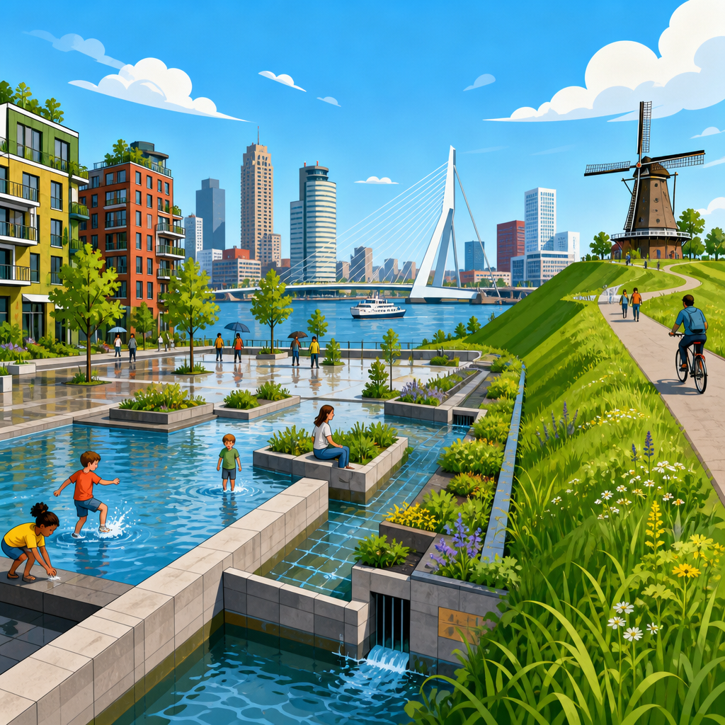
Climate adaptation in Rotterdam is not a future concept; it is a daily design discipline shaped by tides, storms, river discharge, and urban growth. In a city where large districts sit below sea level and where the Rhine-Meuse-Scheldt delta concentrates people, industry, transport, and housing, climate adaptation means adjusting the built environment so neighborhoods continue to function during heavier rainfall, higher temperatures, longer droughts, and rising seas. In practical terms, that includes water squares that temporarily store stormwater, reinforced dikes that reduce flood risk, public spaces designed to absorb heat, and street layouts that manage water rather than simply move cars.
Rotterdam matters because it is one of the clearest real-world examples of how a port city can shift from defensive flood control alone to layered, urban-scale resilience. After years of working around municipal adaptation plans and Dutch water management practice, I have seen why Rotterdam is cited so often: it combines hard infrastructure with public design, governance, and spatial planning. Instead of treating climate adaptation as a single engineering project, the city treats it as a continuous policy framework linking safety, housing, transport, ecology, and public space. That approach is increasingly relevant to coastal and river cities worldwide.
Several key terms define the discussion. Climate adaptation is the process of reducing vulnerability to current and expected climate impacts rather than only cutting emissions. Flood resilience means limiting damage and restoring function quickly when water systems are stressed. Water-sensitive urban design refers to streets, squares, roofs, and parks that store, infiltrate, delay, or safely convey water. Dikes are embankments engineered to keep rivers or sea water from inundating land, while storm surge barriers are movable structures that close under extreme conditions. In Rotterdam, these terms are not abstract. They guide zoning, capital works, maintenance schedules, and even the shape of plazas and schoolyards.
The stakes are high. The Netherlands has sophisticated national flood protection standards, yet climate risk is changing faster than older urban systems were designed to handle. Rainstorms are becoming more intense, heat stress is increasing in dense districts, and drought can damage foundations and green space even in a city known for water. Rotterdam’s response shows why adaptation now requires integrated urban design: people need safe homes, reliable infrastructure, usable public space, and economic continuity at the same time. This hub article explains how water squares, dikes, and urban design work together in Rotterdam, and why the city’s model has influence far beyond the Netherlands.
Why Rotterdam Became a Global Climate Adaptation Reference
Rotterdam’s geography explains its urgency. The city sits in a low-lying delta connected to the North Sea and major European rivers. That position made Rotterdam one of the world’s most important ports, but it also exposed the city to coastal storm surges, river flooding, and groundwater management challenges. The 1953 North Sea flood, which killed more than 1,800 people in the Netherlands, led to the Delta Works, the country’s landmark flood defense program. Although Rotterdam itself has not repeated that scale of disaster, the memory of 1953 still shapes Dutch planning culture: flood safety is never treated as optional.
What makes Rotterdam distinctive is that it moved beyond the older model of simply building higher barriers. The city and its partners adopted a multilayered approach often described through prevention, spatial adaptation, and crisis management. Prevention includes dikes, levees, pumps, and the Maeslantkering storm surge barrier near Hoek van Holland. Spatial adaptation means designing urban areas to cope with excess water, heat, and drought. Crisis management covers emergency planning, warning systems, and recovery capacity. In my experience, this layered thinking is what other cities often miss when they try to copy Rotterdam by focusing on a single flagship project.
Rotterdam Climate Proof, launched through the Rotterdam Climate Initiative, helped formalize this urban adaptation agenda. The city set goals to become more resilient by preparing public space and infrastructure for heavier rainfall and extreme weather. Rather than treating adaptation as a niche environmental program, planners tied it to neighborhood renewal, architectural quality, and economic competitiveness. That integration matters. A plaza that stores water is easier to fund and maintain when it also improves recreation, school access, and district identity.
Rotterdam also benefits from strong institutions. Municipal departments coordinate with the regional water board, the national government, engineering firms, universities, and designers. In the Dutch system, water boards have legal responsibilities and taxation powers, which gives water management continuity that many cities lack. The result is a planning culture where adaptation is embedded in permits, public works, and long-term investment. That institutional depth is less visible than famous projects, but it is the reason Rotterdam’s adaptation measures are durable rather than symbolic.
Water Squares: Public Space That Stores Stormwater
Water squares are Rotterdam’s most widely recognized adaptation feature because they make hydrology visible. A water square is a multifunctional public space designed to remain usable in dry weather while temporarily storing rainwater during cloudbursts. Instead of overwhelming sewers, runoff from roofs, streets, and nearby blocks is directed into a lowered basin. The square fills only when intense rainfall exceeds normal drainage capacity, then empties gradually into the water system once the storm passes. This reduces peak loads, lowers localized flood risk, and creates civic space rather than hidden infrastructure.
The best known example is Benthemplein, designed by De Urbanisten and completed in central Rotterdam near schools and dense urban blocks. On ordinary days, the site functions as a sports and social space with basketball courts, seating, and distinct basins. During heavy rain, water is channeled through visible gutters into depressions that can store large volumes temporarily. That visible flow is not just aesthetic. It educates residents about how stormwater moves through the city and normalizes adaptation as part of daily life. Few conventional underground tanks create that public understanding.
From a technical standpoint, water squares work because they separate rainfall events by frequency and intensity. Smaller storms can be handled through routine drainage and infiltration, while larger events use surface storage as an emergency buffer. The design must consider catchment size, storage depth, safety, maintenance access, discharge rate, and water quality. In practice, that means engineers and landscape architects collaborate early. If the basin is too deep, it becomes unsafe or socially unusable. If outflow is too slow, standing water becomes a maintenance and health problem. Good design solves both civic and hydraulic needs.
Water squares are not a universal solution. They need available land, careful programming, and local public acceptance. They also work best as part of a wider network that includes green roofs, permeable surfaces, larger retention areas, and upgraded sewer systems. Still, they are powerful because they deliver multiple benefits in compact neighborhoods where large parks or detention ponds may be impossible. In Rotterdam, they show that climate adaptation can improve urban life instead of merely restricting it.
| Adaptation measure | Main purpose | Rotterdam example | Primary benefit |
|---|---|---|---|
| Water square | Temporary stormwater storage | Benthemplein | Reduces sewer overload and street flooding |
| Dike reinforcement | Flood prevention from sea and rivers | Regional dike upgrades | Lowers catastrophic inundation risk |
| Storm surge barrier | Protection during extreme coastal events | Maeslantkering | Safeguards port and urban areas |
| Green roof | Delay runoff and cool buildings | City rooftop programs | Cuts heat and water peaks |
| Floating construction | Adapt to changing water levels | Floating Pavilion, Nassauhaven concepts | Adds flexibility in waterfront zones |
Dikes, Barriers, and the Engineering Backbone of Safety
Water squares attract headlines, but dikes remain the backbone of Rotterdam’s safety strategy. A dike is not just a raised earthen wall. It is a regulated flood defense system with standards for height, stability, seepage control, revetment, and inspection. In the Netherlands, flood defenses are assessed against legal protection levels based on probabilities and consequences. Rotterdam depends on a network of primary flood defenses along rivers and coast-linked zones, supported by pumping stations, sluices, and compartmentalization measures that limit how far water can spread if one line fails.
The Maeslantkering is central to understanding Rotterdam’s layered protection. Completed in 1997 as part of the Delta Works, it is a movable storm surge barrier near the Nieuwe Waterweg. Its two enormous sector gates remain open for shipping under normal conditions and close only when forecast sea levels exceed critical thresholds. The system reflects Dutch engineering pragmatism: keep the port accessible while preserving safety during rare but dangerous events. It is not a substitute for dikes; it complements them by reducing surge levels that would otherwise stress inland defenses.
Dike reinforcement has become more complex as climate projections evolve. Higher sea levels can increase baseline water levels, while river flooding may intensify with extreme upstream rainfall. Safety programs now combine geotechnical analysis, probabilistic risk modeling, and asset management. In plain terms, engineers assess whether a dike may overtop, erode, slump, or fail through piping, where water seeps under the structure and carries soil away. Reinforcement may involve widening, adding sheet piles, strengthening inner slopes, or redesigning adjacent spaces so the defense integrates with roads, housing, and waterfront access.
Rotterdam’s example shows a critical truth: hard infrastructure is indispensable, but it cannot do everything alone. Defenses are designed around assumptions, and climate uncertainty means redundancy matters. If a city relies only on barriers and pumps, it becomes brittle when conditions exceed design thresholds. By pairing strong outer defenses with urban measures that slow, store, and direct water safely inside the city, Rotterdam reduces both the probability of flooding and the severity of disruption when systems are stressed.
Urban Design for Heat, Drought, and Everyday Resilience
Climate adaptation in Rotterdam is broader than flood control. Urban design now addresses heat stress, drought, biodiversity, and public health because these risks interact. Dense districts with dark pavement and limited canopy can become significantly hotter during summer heatwaves, especially at night. Older residents, children, and people in poorly insulated homes are most exposed. That is why adaptation plans increasingly include shade trees, reflective materials, water features, ventilation corridors, and building retrofits. Cooling the city is not cosmetic; it is a public health intervention.
Green roofs are one of Rotterdam’s practical tools because they address several problems at once. A well-designed green roof can temporarily retain rainfall, reducing runoff peaks, while also insulating buildings and lowering rooftop temperatures. Rotterdam has promoted rooftop use through subsidies, demonstration projects, and broader rooftop strategies that consider solar energy, water retention, and public access together. Blue-green roofs go further by adding controlled water storage beneath vegetation layers. I have found these systems especially valuable in dense districts where ground-level space is scarce and every square meter must work harder.
Drought may sound counterintuitive in a Dutch port city, but it is increasingly relevant. Longer dry periods can stress trees, reduce soil moisture, and contribute to subsidence or foundation issues in some contexts. Permeable soil areas, open water connections, and resilient planting palettes help cities avoid whiplash between cloudbursts and dry spells. Rotterdam’s adaptation logic therefore emphasizes the full water cycle. Water is not only something to keep out; it must also be stored, reused, infiltrated, and managed seasonally.
Urban design also shapes behavior. A shaded square invites use during hot weather. A schoolyard designed as temporary retention space teaches children what resilience looks like. A waterfront district with clear evacuation routes and raised critical utilities recovers faster after disruption. These are design decisions, not afterthoughts. Rotterdam’s success comes from embedding them into ordinary projects such as street renewal, housing development, and public realm upgrades, where adaptation budgets can align with routine capital spending.
Governance, Tradeoffs, and Lessons Other Cities Can Use
Rotterdam’s adaptation model works because governance is as important as design. Municipal planners, the water board, the Port of Rotterdam, housing corporations, engineers, and residents all influence outcomes. Without coordination, one agency may enlarge green space while another installs utilities that reduce infiltration or block future storage. Dutch planning practice is comparatively strong at aligning these interests through long-term plans, technical standards, and iterative public investment. That institutional consistency is one of Rotterdam’s least glamorous but most transferable lessons.
There are also real tradeoffs. Water plazas require maintenance and can be expensive relative to standard paving. Dike upgrades may conflict with heritage views, private property, or waterfront access. Green infrastructure can underperform if maintenance budgets are cut or if soils are compacted during construction. Floating or amphibious development can be useful in specific sites, but it is not a mass solution for metropolitan housing demand. Serious adaptation planning acknowledges these limits instead of presenting every visible innovation as universally scalable.
For other cities, the most useful lesson is not to copy Rotterdam literally but to apply its principles. First, map risk in detail: flood depth, rainfall bottlenecks, heat exposure, vulnerable populations, and critical assets. Second, prioritize layered systems over single defenses. Third, integrate adaptation into routine planning documents, street standards, zoning, and capital programs. Fourth, measure performance with clear indicators such as retained runoff volume, canopy cover, avoided disruption, and emergency access reliability. Finally, communicate the strategy through projects residents can see and use. Trust grows when adaptation improves daily life, not just regulatory compliance.
Rotterdam demonstrates that climate adaptation succeeds when engineering, landscape architecture, and public policy operate as one urban system. Water squares reduce stormwater pressure while serving neighborhoods. Dikes and the Maeslantkering provide essential protection against catastrophic flooding. Green roofs, cooler streets, and resilient public spaces address heat and drought while improving livability. The city’s deeper achievement is coordination: it links infrastructure with governance, design quality, and long-term maintenance. That is why Rotterdam remains a leading reference for urban planning and policy.
The core takeaway is simple. Effective climate adaptation does not rely on a single heroic structure or one policy document. It requires layered defenses, visible public-space solutions, and institutions capable of updating plans as climate risks evolve. Cities that start now can reduce damage, protect public health, and create better neighborhoods at the same time. Use Rotterdam as a guide, assess your own city’s risks honestly, and build adaptation into every project that shapes the urban environment.
Frequently Asked Questions
1. What does climate adaptation mean in Rotterdam, and why is it such a central part of urban design?
In Rotterdam, climate adaptation means designing the city so it can keep working during and after climate-related stress such as cloudbursts, river flooding, heat waves, drought, and sea-level rise. This is especially important because much of the city lies below sea level and sits within a densely used delta where water, transport, industry, housing, and public space all compete for room. Adaptation is not treated as a distant environmental goal. It is a practical design framework that influences streets, squares, parks, sewers, building plots, waterfronts, and major flood defenses.
The reason it is so central is simple: Rotterdam cannot rely on a single protective measure. Dikes, storm surge barriers, pumping systems, and drainage infrastructure remain essential, but they are only part of the picture. Climate change brings multiple types of risk at once. Heavier rainfall can overwhelm conventional drainage. Hotter summers can make dense neighborhoods uncomfortable or even dangerous. Longer dry periods can stress urban vegetation and affect soil conditions. Rising seas and fluctuating river discharge increase pressure on the city’s long-established water management systems. Because of this, urban design in Rotterdam increasingly combines flood protection with water storage, cooling, shading, permeable surfaces, and flexible public space.
What makes Rotterdam notable is that adaptation is embedded into everyday planning rather than added at the end. A street can be designed to slow and temporarily store water. A public square can double as emergency rainwater retention. A roof can reduce runoff while also improving insulation and biodiversity. A waterfront district can be planned with elevated buildings, resilient infrastructure, and safer evacuation logic. In this way, climate adaptation becomes a daily design discipline: not one big project, but a coordinated set of choices that help neighborhoods remain livable, safe, and functional under changing environmental conditions.
2. What are water squares, and how do they help Rotterdam deal with heavy rainfall?
Water squares are multifunctional public spaces designed to serve everyday urban life during dry weather and temporarily store rainwater during intense storms. They are one of Rotterdam’s most recognizable climate adaptation strategies because they turn a technical water-management challenge into a visible, usable, and well-designed civic feature. Instead of sending all stormwater directly into overloaded sewers, a water square captures runoff from surrounding streets, roofs, and paved areas and holds it for a limited time until the drainage system can process it or the water can be released in a controlled way.
In practical terms, a water square often looks like an ordinary plaza, sports court, or neighborhood gathering space, but its levels, edges, slopes, drains, and storage basins are carefully engineered. During normal conditions, people may use the area for recreation, play, walking, or events. During a cloudburst, lower sections fill with water, keeping nearby streets and buildings safer by reducing surface flooding. This approach creates extra storage capacity without requiring large hidden infrastructure alone, which is especially valuable in dense urban areas where space is limited and expensive.
The broader importance of water squares goes beyond drainage. They help residents understand that water management is part of city life, not something that happens only behind dikes or underground pipes. They also support a more flexible planning philosophy in which public space performs several roles at once: social, spatial, environmental, and hydraulic. In Rotterdam, this matters because adaptation must happen within a living city, not outside it. Water squares demonstrate how resilience can be built into neighborhoods in a way that is functional, educational, and urbanistically attractive.
3. How do dikes and large flood defenses still matter if Rotterdam is also redesigning neighborhoods for climate resilience?
Dikes and large-scale flood defenses remain the backbone of Rotterdam’s safety strategy. Neighborhood-level adaptation measures are important, but they do not replace the fundamental role of primary flood protection. In a delta city exposed to the sea, tides, storm surges, and major river flows, large hydraulic structures are what reduce the risk of catastrophic flooding in the first place. Dikes, barriers, embankments, sluices, and pumps create the baseline level of protection that makes urban life possible across low-lying districts.
What has changed is the recognition that relying only on perimeter defense is no longer enough. Even a well-protected city can face serious disruption from extreme rainfall, localized flooding, heat stress, infrastructure failure, or cascading effects across transport and utilities. That is why Rotterdam’s climate adaptation approach works on multiple layers. At the regional scale, flood defenses protect against large external water threats. At the city and district scale, urban design helps absorb shocks, manage runoff, reduce vulnerability, and support faster recovery. In other words, dikes help keep major water threats out, while resilient urban design helps the city function when water still appears inside the system through rainfall, seepage, overflow, or operational stress.
This layered approach is also more realistic under climate uncertainty. Sea levels may rise, storms may intensify, and river regimes may become less predictable. Strengthening dikes remains essential, but so does planning for exceedance, temporary disruption, and adaptation over time. Rotterdam’s model is authoritative because it treats flood safety not as a single wall against nature, but as a coordinated system of engineering, governance, spatial planning, and public design. That balance is one reason the city is often studied internationally as a leader in practical climate resilience.
4. How does urban design in Rotterdam address heat, drought, and everyday livability alongside flood risk?
Climate adaptation in Rotterdam is not just about keeping water out or storing rainwater. It is also about making neighborhoods more comfortable and reliable during hotter summers and longer dry periods. Dense urban areas can trap heat, especially where there is a lot of asphalt, concrete, dark surfaces, and limited shade. This creates urban heat island effects that raise temperatures, increase health risks, and reduce comfort in homes, streets, and public spaces. At the same time, drought can stress trees and planting systems, lower groundwater in some areas, and affect the performance of green infrastructure if it is not designed carefully.
To address these challenges, Rotterdam increasingly uses urban design measures such as more street trees, shaded routes, pocket parks, green roofs, facade planting, open water connections, and surfaces that absorb rather than repel rainfall. These features help cool the city through shade and evapotranspiration while also improving stormwater management. A greener public realm can reduce peak temperatures, support biodiversity, improve air quality, and make neighborhoods more attractive for daily use. Importantly, these measures are most effective when they are integrated rather than isolated. A tree-lined street with permeable paving and subsurface water storage, for example, can contribute to both cooling and flood resilience.
There is also a social dimension to this work. Climate adaptation affects public health, mobility, housing quality, and access to safe outdoor space. Well-designed resilient neighborhoods are easier to walk through during heat, less likely to flood during storms, and better able to maintain quality of life during weather extremes. In Rotterdam, that means adaptation is tied closely to livability. The goal is not only to defend the city from climate impacts, but to shape a more durable urban environment where residents can continue to live, move, work, and gather comfortably as conditions change.
5. Why is Rotterdam often seen as a global example of climate adaptation, and what can other cities learn from it?
Rotterdam is widely recognized because it treats climate adaptation as a design and governance challenge, not only an engineering problem. Many cities have flood infrastructure, but Rotterdam stands out for combining large-scale water management with neighborhood-scale urban design, public-space innovation, and long-term spatial planning. It has had to do this because the stakes are unusually high: the city is economically strategic, densely developed, and physically exposed within a delta system. That pressure has encouraged a practical, experiment-driven culture in which adaptation is visible in streetscapes, waterfront planning, civic projects, and redevelopment strategies.
Other cities can learn several important lessons from Rotterdam. First, adaptation works best when it is integrated into regular planning and investment cycles rather than treated as a separate emergency topic. Roads, housing projects, public squares, schools, and infrastructure upgrades all become opportunities to improve resilience. Second, multifunctional design matters. A public space can also store water. A roof can also retain rainfall and reduce heat. A landscaped corridor can also support drainage and cooling. This makes adaptation more politically and financially feasible because each intervention delivers multiple benefits. Third, public understanding matters. Visible projects help residents see why adaptation is necessary and how the city is responding.
Perhaps the most valuable lesson is that resilience is cumulative. No single project solves climate risk, especially in a complex urban delta. Progress comes from assembling many coordinated measures across scales: dikes, barriers, drainage systems, water squares, green infrastructure, building standards, land-use planning, and maintenance regimes. Rotterdam’s example shows that climate adaptation can be both technically rigorous and urbanistically ambitious. It is not about turning the city into a fortress or sacrificing urban quality. It is about designing a city that can live with water, heat, and uncertainty while continuing to function well for the people who depend on it every day.


