Flood gate, pump, and seawall projects are among the most visible responses cities deploy when rising water threatens homes, transit, utilities, and local economies. In urban planning and policy, these projects sit at the intersection of engineering, land use, emergency management, public finance, and environmental law. A flood gate is a movable barrier that closes across a channel, tunnel, roadway, or stormwater outfall to block incoming water during a surge or high tide. A pump system removes water that collects behind barriers or in low-lying basins when gravity drainage no longer works. A seawall is a hardened edge, usually concrete, steel, stone, or a composite structure, built to reduce wave attack and hold a shoreline line in place.
These tools matter because many cities now face compound flood risk rather than a single hazard. Heavy rainfall can arrive at the same time as high tide. Storm surge can back water into drainage networks. River flooding can coincide with groundwater rise. I have worked on resilience planning discussions where elected officials initially treated a seawall as a complete answer, only to realize later that drainage, access, maintenance, insurance, and neighborhood design determined whether the wall actually protected people. Physical infrastructure can reduce risk substantially, but it does not erase exposure, eliminate residual risk, or replace evacuation, building standards, and land use policy.
The core planning question is not whether flood gates, pumps, and seawalls work. They do work when properly designed, financed, operated, and integrated with a broader system. The real question is what problem each solves, under what design conditions, for how long, and at what cost or tradeoff. That distinction matters for capital budgeting, climate adaptation, and public trust. Residents deserve a direct answer: these projects can lower flood frequency and damage in targeted areas, but they cannot guarantee zero flooding, stop sea level rise, or protect every parcel equally.
This hub article explains what each project type does well, where each falls short, how cities combine them, and which policy choices determine success. It also clarifies why urban flood protection must be judged across an entire system: shoreline edge, interior drainage, asset operations, neighborhood access, ecological effects, and future climate assumptions. Used carefully, these projects buy time, protect critical assets, and support adaptation. Used carelessly, they create false confidence and larger losses later.
What Flood Gates Solve, and Where Their Limits Begin
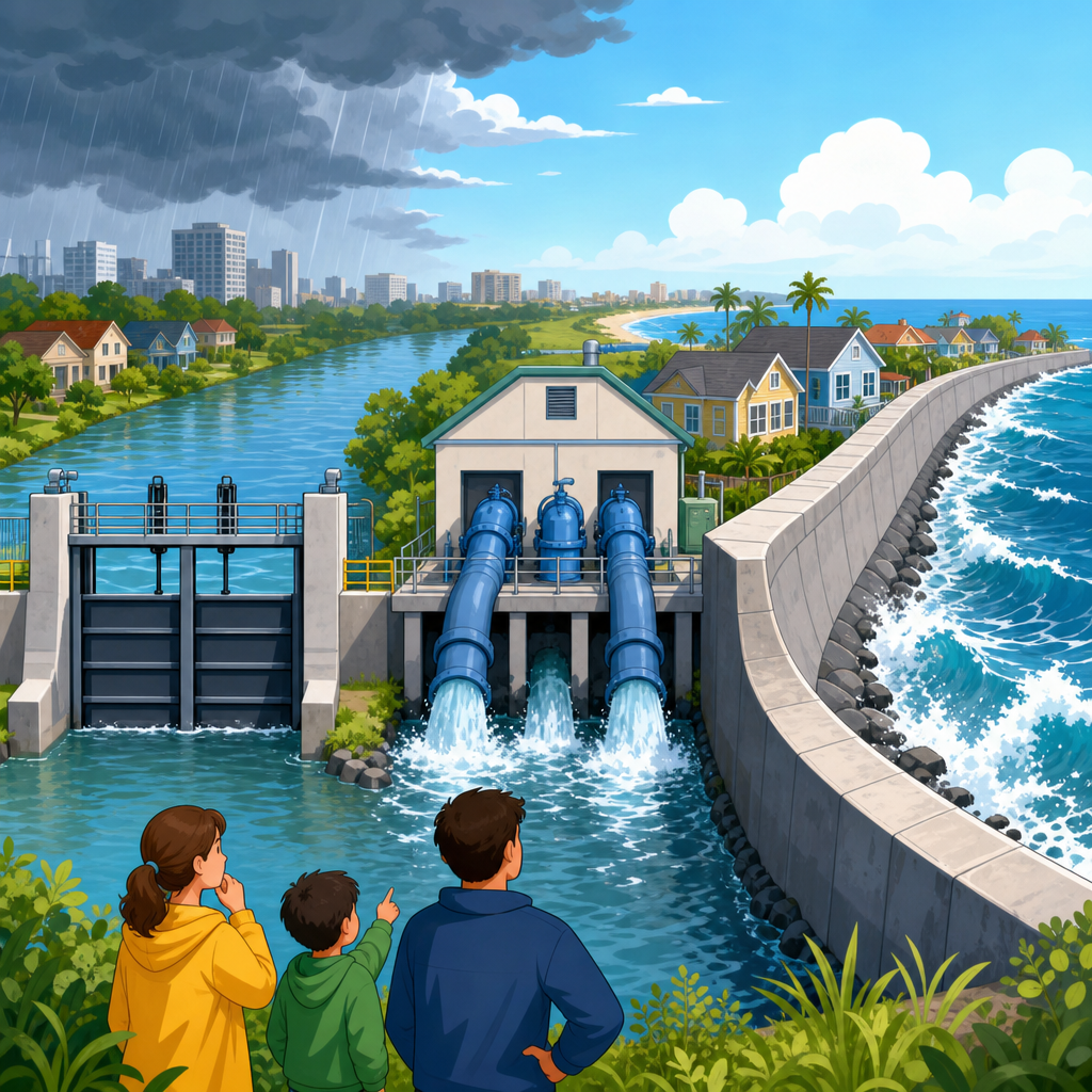
Flood gates are designed to stop water from entering a specific opening or corridor. In practice, that means harbor barriers that close during storm surge, demountable road gates, subway entrance barriers, and flap gates or sluice gates on stormwater outfalls. Their strength is precision. Instead of armoring every inch of shoreline to the same elevation, a city can target vulnerable openings and close them only when conditions demand it. The Thames Barrier in London is the classic example: it reduces surge risk along the tidal Thames and protects dense urban assets upstream. Similar logic drives sector gates, vertical lift gates, and rotating barriers in ports and navigation channels.
What flood gates solve best is episodic coastal or tidal intrusion. They are especially effective where a defined pathway allows water to enter and where closure can occur with enough lead time. Gates also preserve views, navigation, and waterfront access better than a continuous permanent wall in some settings. However, gates do not solve inland rainfall flooding behind the barrier. Once the gate closes, any rain falling inside the protected area must be stored, infiltrated, or pumped out. Gates also depend on forecasts, operators, backup power, mechanical reliability, and clear protocols. If closure happens too late, if debris jams the mechanism, or if the design event is exceeded, protection can fail.
There are also governance limits. Large barriers raise difficult questions about who is protected, who pays, and whether risk is shifted downstream or across the harbor. Environmental review often focuses on sediment transport, fish movement, water quality, and navigation impacts. Gates are therefore not stand-alone shields; they are operational assets embedded in legal, ecological, and budget systems.
What Pumps Can Solve in Low-Lying Urban Areas
Pumps solve a different problem: they move water when gravity cannot. Any city with shallow slopes, high groundwater, subsiding land, or high tailwater conditions eventually confronts drainage failure during storms. In normal conditions, stormwater leaves streets and pipes through gravity outfalls. During a surge, high tide, or river flood, those outfalls may be closed or submerged. Pump stations then become essential because they lift interior water over a levee, through a force main, or into a receiving water body when natural drainage is blocked.
New Orleans offers the clearest real-world lesson. Its drainage system relies on canals, gates, and powerful pumps because large parts of the city sit below sea level. Rotterdam, Miami, and parts of coastal Houston use pumping in different ways, often combined with detention and tide control. In my experience reviewing drainage concepts, the biggest public misunderstanding is assuming a bigger pump means unlimited protection. It does not. Pumps are sized for a design storm, measured through flow rates, storage assumptions, and acceptable levels of service. If rainfall intensity exceeds design capacity, streets and basements can still flood. If power fails and backup generation is inadequate, pumping can stop exactly when it is most needed.
Pumps also require constant maintenance. Screens clog. Impellers wear. Corrosion is relentless in saline environments. Operators need telemetry, spare parts, fuel planning, and redundant units. Energy demand can be substantial, and operating costs continue long after ribbon cuttings. For planners, the key value of pumps is that they allow already-developed neighborhoods to function under conditions where passive drainage is no longer reliable. Their main limitation is that they manage symptoms of water accumulation; they do not reduce runoff generation or restore natural storage on their own.
What Seawalls Can and Cannot Do Along Urban Shorelines
Seawalls are built to resist wave action, reduce shoreline erosion, and keep water from overtopping the edge during smaller to moderate events. In dense districts with rail lines, roads, bulkheads, ports, or buildings immediately adjacent to the water, a seawall can be the only physically practical near-term measure. Cities such as New York, Boston, San Francisco, and Charleston have evaluated or constructed shoreline walls, revetments, floodwalls, and raised esplanades to protect critical waterfront zones.
A seawall can protect against frequent nuisance flooding and some storm surge if crest elevation, foundation design, tie-ins, and overtopping allowances are adequate. It can also provide a stable edge for public space improvements. Yet seawalls have hard limits. Waves can overtop them. Water can seep under or around them through weak connections, old utility trenches, porous soils, or adjoining low ground. Over time, sea level rise can reduce their effective level of protection unless they are designed for future raising. A wall also does little for rainfall flooding behind it unless pumps, storage, or green infrastructure are added.
Another constraint is induced change to the waterfront itself. Hardened edges can reflect wave energy, worsen scour, reduce intertidal habitat, and disconnect neighborhoods from the water. In some places, a continuous wall can create an unacceptable access or visual barrier. That is why many contemporary urban projects use hybrid designs, pairing floodwalls with parks, berms, deployable segments, and elevated streets rather than relying on a blank vertical edge alone.
How These Systems Work Together in Practice
The most effective urban flood protection systems combine barriers at the edge with drainage and emergency operations inside the protected area. That integrated approach is necessary because flood pathways are interconnected. A seawall can keep surge out, but closed outfalls trap rainfall. A gate can block a canal, but interior streets still need storage and pumping. A pump can move stormwater, but if the shoreline edge is overtopped, inflow may exceed capacity immediately. Good planning starts with source, pathway, receptor analysis: where water comes from, how it travels, and what assets it harms.
| Project type | Best at solving | Cannot solve alone | Typical companion measures |
|---|---|---|---|
| Flood gate | Blocking surge or tide through specific openings | Interior rainfall flooding, power loss, access continuity | Pumps, storage, warning systems, closures protocol |
| Pump station | Removing trapped water when gravity drainage fails | Shoreline overtopping, runoff reduction, unlimited capacity | Detention, backup power, tide gates, pipe upgrades |
| Seawall or floodwall | Reducing wave attack and keeping routine high water out | Groundwater rise, seepage, inland drainage, habitat restoration | Raised grades, pumps, berms, living shorelines, zoning |
Tokyo, for example, relies on a layered strategy that includes levees, coastal structures, pump stations, underground storage, and strict operations. The Netherlands uses the concept of multiple layers of safety: prevention through defenses, spatial planning to reduce consequences, and disaster management for residual risk. That is the right way to think about urban projects everywhere. No single device solves flooding. Systems reduce probability, consequence, or recovery time, and the best programs address all three.
Policy, Equity, and Environmental Tradeoffs
Engineering decisions become policy decisions the moment a project line is drawn on a map. A barrier that protects one district can leave another exposed or worsen drainage patterns elsewhere. Financing usually involves a mix of local capital funds, state programs, resilience bonds, utility fees, and federal sources such as FEMA hazard mitigation grants or US Army Corps of Engineers participation. Because these projects are expensive, cities often prioritize central business districts, hospitals, airports, wastewater plants, and transit hubs. That can be rational from a critical infrastructure standpoint, but it raises fairness concerns when lower-income neighborhoods face equal or greater household risk.
Environmental tradeoffs are equally real. Seawalls can squeeze coastal habitats against rising water, a process often called coastal squeeze. Gates can alter salinity and circulation patterns if used frequently. Pump discharges can affect receiving water quality, especially in combined sewer systems or canals with low flushing. Regulatory review under wetland, coastal zone, navigation, and water quality rules can therefore reshape project design significantly. In many cases, planners now evaluate nature-based features, such as marsh benches, oyster reefs, mangrove restoration, and floodable parks, alongside hard infrastructure because they can reduce waves, provide habitat, and improve public space, even though they rarely replace major structural protection in dense cores.
Risk communication is another policy issue. Once a wall or gate is announced, property owners may assume the problem is solved permanently. That is dangerous. Every protected area has residual risk from overtopping, mechanical failure, events beyond design assumptions, or long-term climate change. Honest communication about those limits improves evacuation compliance, insurance decisions, and building-level preparedness.
How Cities Should Evaluate Whether a Project Is Worth Building
A sound decision begins with flood modeling, asset inventory, and a clear performance target. Planners need to specify the design event, such as the annual chance storm or surge level, and include sea level rise scenarios, compound flooding, and asset criticality. Cost-benefit analysis matters, but narrow damage-avoidance calculations can miss public health, displacement, business continuity, and network effects. A pump protecting a hospital district may be justified even if the direct parcel damage estimate alone seems modest. Likewise, a seawall with no drainage upgrade may look efficient on paper yet underperform in actual storms.
Operational realism is the acid test. Who closes the gate at 2 a.m.? What if a storm arrives during a power outage? How many hours of storage exist behind the wall before pumps are overwhelmed? Are maintenance funds legally committed for thirty years, or only assumed? I have seen concept plans look impressive until the operations team reviewed access routes, spare parts, and staffing. The best projects include lifecycle costing, redundancy, staged adaptation pathways, and trigger points for future raising or expansion. They also connect structural works with building codes, floodproofing standards, insurance strategy, and, where necessary, managed retreat from the highest-risk parcels.
For city leaders, the practical test is simple: build flood gates, pumps, and seawalls to solve the problems they are actually good at solving, not the political promise people wish they could make. When these projects are matched to local hazards, operated well, and combined with land use, drainage, and emergency planning, they protect lives, infrastructure, and tax base. When oversold, they create brittle systems and false security. Use this hub as a starting point for every urban flood protection decision: define the hazard, identify the pathway, measure the residual risk, and choose layered solutions that can adapt as water levels and storms change.
Frequently Asked Questions
1. What problems can flood gates, pumps, and seawalls realistically solve?
Flood gates, pumps, and seawalls are designed to reduce specific types of flood risk, not eliminate all flooding. In practical terms, they can help protect neighborhoods, roads, transit lines, utilities, industrial sites, and downtown districts from storm surge, high tides, and certain forms of coastal or tidal backflow. A flood gate can close off a vulnerable opening such as a canal entrance, tunnel portal, roadway dip, or stormwater outfall so that rising outside water does not push inland. A pump system can then remove rainwater or trapped interior water from the protected side when gravity drainage no longer works. A seawall can add a fixed line of defense by reducing direct wave attack and limiting the reach of high water along a shoreline.
These systems are often most effective when they are part of a broader flood protection network rather than a single stand-alone project. For example, a seawall may reduce overtopping at the waterfront, gates may protect drainage connections and access points, and pumps may handle the rain that falls inside the defended area during a storm. In that sense, they can buy time, reduce physical damage, support emergency operations, and lower the frequency of disruptive but predictable flooding events. They can also protect critical infrastructure that is expensive or difficult to relocate, including substations, hospitals, wastewater facilities, rail assets, and evacuation routes.
What they solve best is exposure to defined water conditions that engineers can model, such as a projected surge height, a tidal threshold, or a target storm event. They are particularly useful where there is a concentrated area of high-value development, limited space, and strong public justification for hard infrastructure. But even in those settings, they are best understood as risk-reduction tools. They can reduce probability and severity of damage, but they do not create total safety or remove the need for land-use planning, insurance, emergency preparedness, and building-level adaptation.
2. What can these projects not solve, even when they are large and expensive?
The most important limitation is that these projects cannot stop water from finding other pathways. A seawall may hold the shoreline line, but water can still arrive through groundwater rise, sewer backups, intense rainfall, upstream river flooding, or overtopping during a storm larger than the design standard. A flood gate can block an opening, but if surrounding land is lower than the protected barrier or if connected drainage systems are overwhelmed, flooding can still occur. Pumps can move water out, but only up to their rated capacity and only if power, maintenance, and discharge conditions allow them to operate as intended.
They also cannot solve the long-term land-use question of whether development should continue in highly exposed places. Hard defenses may protect existing investments for a time, but they do not automatically make every low-lying parcel suitable for new growth. In some cases, protective infrastructure can create a false sense of security that encourages more building behind the barrier, increasing the consequences if the system fails or is exceeded. This is sometimes called residual risk: even after a major project is built, meaningful risk remains.
Another major limitation is that these projects cannot fully address social vulnerability on their own. Physical barriers do not guarantee that renters, small businesses, elderly residents, transit-dependent workers, or environmental justice communities are equally protected. If project benefits are unevenly distributed, if maintenance costs divert resources from other neighborhoods, or if floodwaters are displaced toward less protected areas, then a technically successful project may still produce inequitable outcomes. In policy terms, flood infrastructure solves a hydraulic problem only partially; it does not automatically solve housing instability, displacement pressure, emergency access challenges, or the fiscal burden of repeated adaptation.
Finally, they cannot freeze future climate conditions in place. Sea levels can continue rising, storms can change, and rainfall patterns can intensify beyond what earlier design assumptions anticipated. A project that performs well today may require upgrades, operational changes, or complementary measures sooner than expected. That is why cities increasingly pair hard infrastructure with zoning changes, building retrofits, wetland restoration, managed retreat strategies in some areas, and updated emergency response planning.
3. Why are pump systems so important in areas protected by flood gates or seawalls?
Pumps are essential because once a gate is closed or a seawall prevents outside water from draining away naturally, rainwater and local runoff can become trapped inside the protected area. Under normal conditions, many urban drainage systems rely at least in part on gravity. Water flows downhill through pipes, channels, and outfalls until it reaches a river, bay, or ocean. But during a coastal surge or extreme high tide, that receiving water body may be too high, and water can reverse direction unless a gate blocks it. When that happens, the city still needs a way to move interior stormwater out, and that is where pumps become critical.
In other words, a gate without sufficient pumping can create a different flooding problem behind the barrier. Even moderate rainfall can accumulate quickly in a paved urban basin with limited infiltration. Streets, underpasses, basements, and transit infrastructure may flood from the inside even if the coast is successfully blocked from the outside. Engineers therefore size pumps based on expected rainfall intensity, drainage area, storage capacity, timing, system redundancy, and the amount of acceptable service disruption. They also consider whether there are detention areas, backup generators, multiple pump stations, and fail-safe operations if one component goes offline.
Pumps are important operationally as well as hydraulically. They require power, trained staff, inspections, debris management, routine testing, and clear activation protocols. Intake screens can clog, discharge points can be affected by high tailwater conditions, and mechanical components degrade over time. This means pump systems are not simply capital projects; they are long-term operating commitments. Cities that build gates and walls but underfund pump maintenance often discover that the weakest part of the system is not the visible barrier but the less visible equipment that must perform under stress.
For that reason, pump design is often one of the clearest examples of why flood protection is a systems problem. A successful project must integrate forecasting, drainage modeling, backup power, emergency staffing, asset management, and real-time decision-making. Without that systems approach, even a well-built seawall or gate can fall short of its intended level of protection.
4. Do seawalls and flood gates have tradeoffs for the environment, land use, and nearby neighborhoods?
Yes. These projects can deliver important protective benefits, but they often come with significant environmental, urban design, and governance tradeoffs. Seawalls in particular can alter shorelines by reflecting wave energy rather than absorbing it, which may increase erosion or scour in adjacent areas. They can disconnect communities from the water, reduce intertidal habitat, and interfere with the inland migration of wetlands as sea level rises. Flood gates can affect water circulation, sediment movement, aquatic habitat, and water quality depending on where and how often they operate. Large pump discharges can also influence receiving waters during storm events.
From a land-use perspective, hard defenses can shape what gets protected and what does not. That makes them inherently political. A city may choose to defend a commercial core, port facility, or dense residential district while leaving lower-value or less politically visible areas with fewer protections. Those decisions can affect property values, investment patterns, insurance expectations, and long-term development pressure. In some cases, a project can shift flooding to neighboring communities or create edge conditions where water concentrates at the limits of the defended area.
There are also public realm considerations. A tall seawall may reduce views, limit waterfront access, or require redesign of parks, streets, and utilities. A gate structure across a channel may affect navigation, recreation, or aesthetics. These are not secondary issues; they influence public acceptance, permitting, and the overall success of a project in a city setting. Well-designed projects increasingly try to combine protection with open space, habitat features, trail networks, and urban design improvements, but those benefits usually require more coordination, more funding, and more complex review.
Legally and institutionally, tradeoffs appear in permitting, maintenance responsibility, and liability. Coastal projects may trigger review under environmental statutes, floodplain rules, navigation laws, wetlands protections, and local shoreline regulations. Agencies may disagree on acceptable impacts, design standards, and cost sharing. So while flood gates and seawalls can be effective tools, they are rarely just engineering objects. They are policy choices with physical, ecological, and social consequences that have to be evaluated over decades, not only at ribbon-cutting.
5. If these projects are not complete solutions, what should cities do alongside them?
Cities should treat flood gates, pumps, and seawalls as only one layer in a larger resilience strategy. The strongest approach combines structural protection with land-use controls, building-level adaptation, emergency management, natural systems, and long-term fiscal planning. That means updating zoning and building codes so that new construction is safer, elevating or floodproofing critical equipment, preserving evacuation routes, improving stormwater storage, and reducing development intensity in the most hazard-prone locations when feasible. In some places, it also means planning for phased retreat or property acquisition rather than promising permanent defense everywhere.
Nature-based and hybrid measures can also play a major role. Restored wetlands, dunes, living shorelines, floodable parks, expanded drainage corridors, and permeable landscapes can absorb water, reduce


