
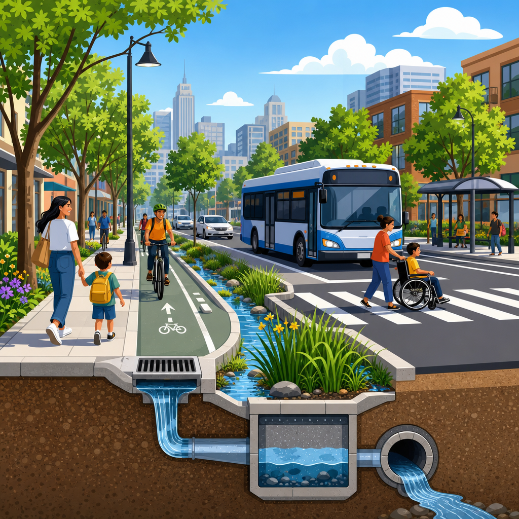
Designing streets as infrastructure for safety, drainage, and transit means treating the public right-of-way as a coordinated system rather than a strip of pavement for moving cars. In practice, a street is an engineered corridor that must prevent crashes, carry stormwater, support buses, serve pedestrians, enable commerce, and remain maintainable over decades. Safety refers to reducing fatal and serious injuries through geometry, speed management, visibility, and conflict reduction. Drainage covers how a street captures, conveys, stores, infiltrates, and cleans runoff during routine storms and extreme rainfall. Transit includes the design features that let buses, trams, shuttles, and riders move reliably, comfortably, and quickly. These functions are interdependent. A wider turning radius may help trucks but can increase crossing distance and speed. A curb extension can shorten pedestrian exposure and create space for bioretention, yet it must be shaped so buses can dock cleanly. A center-running transit lane can improve reliability, but drainage inlets, utility access, and platform design must be resolved together. Cities that separate these topics usually build streets that underperform. Cities that integrate them create corridors that are safer, more resilient, and more productive.
I have worked on corridor studies where crash data, inlet spacing, and bus delay were reviewed by different teams using different base maps, and the result was predictable: expensive redesign late in the process. The better approach is to start with the street cross section as civic infrastructure. That means defining target speed, modal priority, design storm, maintenance access, utility constraints, and curbside use before linework hardens. It also means understanding standards. The best projects typically reconcile guidance from the NACTO Urban Street Design Guide, AASHTO’s Green Book, the MUTCD, ADA requirements, local stormwater manuals, and transit agency operational standards instead of relying on any single document. This matters because streets consume a large share of public capital budgets and shape everyday risk. According to the World Health Organization, road traffic injuries remain a leading cause of death globally, especially for younger people. At the same time, more intense rain events are overwhelming drainage systems, while unreliable surface transit limits access to jobs and services. Street design sits at the center of all three problems, which is why it is one of the most powerful tools available to urban planners and public works departments.
Safety starts with speed, geometry, and predictable conflict points
The clearest principle in street safety is that survivability declines as impact speed rises. That is why street design should begin with target speed, not posted speed. On an urban main street, a target speed around 20 to 25 mph usually aligns better with pedestrian activity than a forgiving geometry that invites 35 mph travel. Designers achieve this through lane widths that match context, corner radii that control turns, median refuges, daylighting at crossings, shorter crossing distances, and signal timing that reduces surprise. When I review collision diagrams, recurring patterns usually trace back to geometry: permissive high-speed right turns, long unsignalized crossings near bus stops, or multilane approaches where one driver yields and another does not. Good design reduces these ambiguous moments.
Protected intersections, raised crossings, leading pedestrian intervals, hardened centerlines, and access management are practical examples. On a commercial corridor with frequent driveways, consolidating entrances and adding a median can reduce left-turn conflict points while improving progression for transit. Near schools, curb extensions and raised crosswalks can make yielding behavior obvious because the crossing reads as part of the street, not an afterthought. For bicyclists and micromobility users, vertical separation or parking-protected lanes reduce overtaking risk, but they must be paired with clear sight triangles at side streets. None of these treatments works in isolation. The best safety outcomes come from a self-enforcing design where the street cues the intended behavior even when enforcement is absent. That is the difference between a corridor that depends on signs and one that is safe by form.
Drainage design turns the curb line into climate infrastructure
Street drainage is often hidden in plan sets, yet it determines whether a corridor remains usable during storms and whether runoff damages downstream waterways. A conventional street sheds water quickly into catch basins and pipes. That can be effective for small storms, but it often pushes larger volumes downstream and misses opportunities to improve water quality. A modern approach combines conveyance with source control: keep runoff shallow on the surface, intercept it at regular intervals, route it to inlets that can be maintained, and where soil and utilities allow, place green infrastructure in the furnishing zone, medians, or curb extensions. Bioretention cells, stormwater planters, permeable parking lanes, and subsurface detention under plazas can all be integrated without compromising accessibility.
The critical design questions are straightforward. Where does water spread during the design storm? How deep will ponding be at crosswalks and transit stops? Can inlets capture debris-laden flow before it bypasses to an intersection? Are overflow routes safe when a pipe clogs? In coastal or riverine cities, backflow prevention and tailwater conditions matter as much as pipe diameter. In freeze-thaw climates, surface texture, deicing practices, and underdrain details affect performance. I have seen beautiful curbside bioretention fail because utility conflicts left too little soil volume, and I have seen simple retrofit curb cuts succeed because maintenance crews were involved early. Drainage design should protect building thresholds, preserve clear pedestrian paths, and avoid creating standing water where riders queue. Done well, it reduces nuisance flooding, improves water quality, and extends pavement life by controlling saturation at the edge of the roadway.
Transit priority works when operations and street design are planned together
Reliable transit is not created by paint alone. Travel time and reliability depend on stop spacing, lane priority, signal treatments, boarding design, fare collection, and curb management. On busy bus corridors, center-running lanes can avoid conflicts with deliveries and right-turn queues, but they require carefully designed median platforms, protected crossings, and drainage solutions that keep platform edges dry. On other streets, curbside bus lanes are more feasible, especially where right-of-way is constrained, but they need strong loading management and camera enforcement to prevent blockage. Queue jumps, transit signal priority, all-door boarding, and stop consolidation often produce measurable gains at relatively low cost.
The operational details matter. A farside stop may reduce delay by letting a bus clear the signal before serving passengers, while an in-lane stop can save merge time and calm traffic, provided the corridor can absorb brief dwell-related queues. Boarding islands can preserve a protected bike lane and let buses stop in the travel lane, but passenger circulation, tactile warning strips, and accessible boarding must be resolved precisely. Agencies such as Transport for London and many North American transit systems have shown that pairing lane priority with stop optimization improves reliability more than either strategy alone. The lesson is simple: transit geometry should reflect service patterns, fleet dimensions, passenger volumes, and signal timing from the start, not be pasted onto a nearly finished roadway plan.
Cross-section choices determine how safety, drainage, and transit interact
The street cross section is where tradeoffs become visible. Every foot assigned to general traffic, parking, planting, cycle tracks, transit lanes, or sidewalks affects the other systems. A common mistake is to debate each element independently. A better method is to test several complete cross sections against clear performance goals: target speed, person throughput, pedestrian level of comfort, stormwater capture volume, freight access, and emergency operations. This forces productive questions. Can a parking lane become a bus lane at peak hours? Can a median double as refuge and bioretention? Can a curb extension include an inlet and still leave enough sweep path for a fire truck?
| Design element | Safety effect | Drainage effect | Transit effect |
|---|---|---|---|
| Curb extension | Shortens crossing distance and improves visibility | Can host bioretention and reduce gutter spread | Helps buses align at stops if shaped correctly |
| Median | Reduces turn conflicts and offers refuge | Can store runoff or guide overflow paths | Supports center platforms and turn control |
| Bus lane | Reduces weaving around stopped buses | Requires careful inlet placement near stops | Improves reliability and travel time |
| Protected bike lane | Separates modes and reduces overtaking risk | Needs frequent drainage gaps and maintenance access | Requires boarding islands at bus stops |
Choosing among these options depends on context. In a dense downtown, curb access and bus frequency may justify offset loading zones, floating bus stops, and high-capacity drainage inlets because turnover and foot traffic are intense. In a suburban retrofit, the bigger opportunity may be converting excess lane width into landscaped swales and median refuges while preserving key truck turns at selected intersections. The point is not to force one template everywhere. It is to use the cross section as an organizing device that aligns engineering, operations, and public realm goals.
Intersections, curb management, and maintenance decide whether the design actually performs
Most serious conflicts and most recurring drainage complaints cluster at intersections and curbs. That is why corridor success often hinges less on midblock elegance than on the hard details: signal phasing, curb return geometry, inlet placement, loading rules, and who maintains what. A bus lane that functions midblock can fail at the intersection if right turns are unmanaged. A beautiful plaza edge can flood if utility covers sit in the low point. A protected bike lane can become hazardous if snow storage blocks sight lines at the corner. These are not minor implementation issues; they are core design questions.
Curb management deserves special attention because the curb is now one of the most contested assets in cities. Deliveries, ride-hail pickups, bus stops, accessible parking, parklets, waste collection, and micromobility parking all compete for the same frontage. The strongest projects map curb demand by time of day and assign uses explicitly instead of leaving space to informal negotiation. Digital curb inventories, camera data, and transit dwell analysis are increasingly useful here. Maintenance planning is equally decisive. Green infrastructure needs sediment removal and plant care. Inlets near tree pits need regular cleaning. Transit platforms need snow clearance priorities. Pavement markings and flexible delineators need replacement cycles. If an agency cannot commit to maintenance, the design should be simplified before construction rather than allowed to degrade into dysfunction.
For practitioners and city leaders, the main takeaway is that streets should be designed as integrated infrastructure with shared performance goals. Start every project by defining target speed, modal priority, design storm, accessibility requirements, and maintenance responsibility. Build the cross section around those decisions, then resolve intersections and curb operations with the same discipline. Use established guidance, but adapt it to local climate, fleet needs, utilities, and land use. When safety, drainage, and transit are coordinated, the benefits compound: fewer severe crashes, less flooding, faster and more reliable buses, better walking conditions, and longer asset life.
This hub page provides the foundation for the broader street design conversation within urban planning and policy. The next step is to apply these principles corridor by corridor, intersection by intersection, and budget by budget. Review your city’s standard details, compare them against current safety and stormwater practice, and identify one corridor where a complete redesign can deliver measurable gains. Streets are public infrastructure at their most visible and most consequential. Design them accordingly.
Frequently Asked Questions
What does it mean to design streets as infrastructure rather than just pavement for cars?
Designing streets as infrastructure means treating the public right-of-way as a multi-function system that must do several jobs at once, reliably and safely. A well-designed street is not simply a travel lane for private vehicles. It is also a safety corridor, a drainage conveyance system, a transit facility, a walking environment, a service access route, and often a front door to homes and businesses. In practical terms, that means engineers and planners coordinate geometry, curb placement, sidewalks, stormwater inlets, bus stops, utilities, crossings, loading needs, and maintenance requirements as parts of one integrated design rather than isolated features added later.
This approach changes how decisions are made. Instead of starting with maximum car throughput and fitting everything else into the leftover space, the design begins with the corridor’s full set of functions and users. Speed, visibility, turning movements, runoff paths, boarding conditions, emergency access, and long-term upkeep all become core design criteria. The result is usually a street that performs better over time: it reduces severe crashes, manages rainfall more effectively, supports reliable transit operations, improves pedestrian comfort, and lowers the risk of expensive retrofits caused by fragmented planning.
How does street design improve safety for everyone who uses the corridor?
Street safety is primarily shaped by design choices that influence speed, predictability, and the number of conflict points between users. The most effective safety strategies are not based on signs alone; they are built into the physical form of the street. Lane widths, curb radii, crossing distances, median treatments, intersection geometry, signal timing, sight lines, and sidewalk separation all affect how people behave. When a street is designed to encourage lower operating speeds and clearer movements, drivers make fewer high-risk maneuvers, pedestrians spend less time exposed in crossings, and transit vehicles can enter and leave stops with fewer conflicts.
Good safety design also focuses on reducing the severity of mistakes. Human error will always occur, so the corridor should be forgiving rather than punishing. Features such as shorter crossings, refuge islands, raised intersections, curb extensions, protected bike facilities, and well-placed lighting can reduce both crash likelihood and crash severity. Visibility is equally important: bus shelters, landscaping, parking, utility poles, and drainage structures must be arranged so they do not block views at critical points. In an integrated design, safety is not a separate layer added after the layout is complete. It is embedded in the geometry, spacing, and operational logic of the street from the beginning.
Why is drainage such an important part of street design?
Drainage is essential because streets are large, continuous hard surfaces that collect and move stormwater quickly. If runoff is not managed correctly, water can pond in travel lanes, weaken pavement, flood adjacent properties, reduce tire traction, obscure lane markings, and create dangerous conditions for pedestrians at crossings and bus stops. Poor drainage can also damage curbs, undermine the base structure, and shorten the life of the corridor, turning what appears to be a transportation issue into a costly maintenance and public safety problem.
Effective street drainage design accounts for surface grading, gutter flow, inlet spacing, utility conflicts, underground conveyance, and maintenance access. It also considers how the street interacts with the broader watershed and drainage network. In many cases, modern practice goes beyond simply moving water away as fast as possible. It incorporates green infrastructure such as bioswales, permeable edges, stormwater planters, and landscaped medians where feasible to slow, filter, and manage runoff more responsibly. The key is integration: curb placement affects gutter capacity, bus stop design affects ponding risk, and cross-slope affects both accessibility and runoff behavior. When drainage is planned as part of the corridor system, the street performs better in everyday rain events and is more resilient during major storms.
How can a street support transit without making the corridor less efficient?
Supporting transit well often makes a corridor more efficient overall because it improves the movement of people, not just the movement of individual vehicles. Streets that accommodate buses effectively use design features such as dedicated or queue-jump lanes where appropriate, well-positioned stops, accessible boarding areas, clear passenger waiting space, and curb management that prevents loading or parking conflicts. Transit reliability depends on details: if buses must weave across traffic to reach stops, stop in pooled water, or re-enter mixed traffic without assistance, delays compound quickly and service becomes less dependable.
An integrated street design helps transit work smoothly while preserving corridor function. Near-side and far-side stop placement, signal priority, lane continuity, curbside regulation, and intersection geometry should be coordinated with pedestrian crossings and drainage features. For example, a bus stop should not force riders to board from a flooded gutter or cross an unsafe turning movement. At the same time, transit-supportive design can reduce overall congestion by making bus service faster and more attractive, allowing more people to travel in less space. In busy urban corridors especially, designing for high-capacity transit is often one of the most effective ways to improve person-throughput, safety, and long-term operational performance at the same time.
What are the biggest trade-offs and long-term considerations in integrated street design?
The biggest trade-offs usually involve limited right-of-way, competing user needs, capital costs, and maintenance responsibilities. Space is finite, so adding wider sidewalks, transit lanes, stormwater features, medians, loading zones, or protected bicycle facilities often requires careful prioritization. The best designs are not those that maximize every feature independently, but those that align the corridor with its context and purpose. A main street serving shops, pedestrians, and buses will need a different balance than an industrial route or a neighborhood connector. The design team must evaluate safety outcomes, drainage performance, transit operations, access needs, and lifecycle costs together rather than optimizing one objective in isolation.
Long-term performance matters as much as initial construction. Streets must remain maintainable over decades, which means materials, inlets, planting systems, pavement structure, and curbside uses should be selected with upkeep in mind. If a drainage feature cannot be cleaned, if a transit stop is inaccessible after resurfacing, or if a safety treatment is routinely blocked by deliveries, the corridor will underperform no matter how well it looked on paper. Climate resilience is another major consideration, since heavier rainfall, heat, and changing travel patterns can stress older assumptions. The most durable street designs are flexible, serviceable, and coordinated across departments. They recognize that the public right-of-way is a long-life civic asset that must safely handle movement, water, access, and daily urban activity all at once.


