
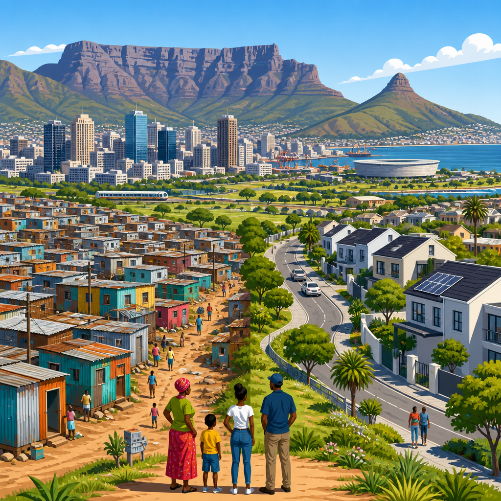
Cape Town’s spatial inequality is one of the clearest examples of how urban form can preserve injustice long after the laws that created it have been repealed. In planning terms, spatial inequality means unequal access to land, housing, transport, jobs, schools, healthcare, public space, and basic municipal services because different groups live in different parts of the city. In Cape Town, that pattern did not emerge by accident. It was produced through colonial land dispossession, hardened by apartheid legislation such as the Group Areas Act, and then carried forward by market dynamics, infrastructure backlogs, and uneven state capacity after 1994.
When I have worked through South African planning documents, transport maps, and housing project evaluations, the same lesson appears repeatedly: geography shapes life chances. A household in well-located areas near the metro’s economic core can reach work more quickly, spend less on transport, and access stronger public amenities. A household pushed to the urban edge often pays a poverty penalty every day through longer commutes, fragmented social networks, and lower access to opportunity. This is why post-apartheid planning in Cape Town matters so much. It is not only about where buildings go. It is about whether democratic urban policy can reverse a city structure designed to exclude.
Cape Town is also unusually important because its landscape makes inequality visible. Table Mountain, the Atlantic Seaboard, and the city bowl sit close to some of the country’s highest-value land. Meanwhile, many low-income and working-class residents live far from major employment concentrations in places such as Khayelitsha, Mitchells Plain, Delft, and Mfuleni. The result is a metro where race, class, mobility, and land value still overlap in ways that planners can measure on a map and residents experience in daily routines.
Understanding Cape Town’s spatial inequality requires attention to several linked questions. How did apartheid planning shape today’s settlement form? Why has democratic planning struggled to integrate the city? What roles do housing delivery, transit investment, land markets, and informal settlement growth play? Which policy tools have produced real gains, and where have they fallen short? Answering those questions makes this hub useful because every detailed topic under urban planning and policy in Cape Town connects back to this core problem: the city remains deeply divided in space, and that division continues to structure inequality in income, time, safety, and opportunity.
How apartheid planning produced the modern city
Cape Town’s current urban structure cannot be understood without the history of forced removals and racially zoned land use. Apartheid planning assigned the best-located land and infrastructure to white residents while relocating Black, Coloured, and Indian communities to peripheral townships. District Six is the most cited example because it symbolized both destruction and displacement, but the broader pattern was metropolitan in scale. The Cape Flats became the dumping ground for communities removed from central and better-served areas, creating large dormitory settlements separated from jobs and amenities.
This mattered because planning was not simply residential sorting. It was an integrated system of control. Road alignments, buffer strips, industrial zoning, rail provision, and public housing location all worked together. Modernist planning principles were used in a deeply political way: single-use zoning, superblocks, and low-density peripheral layouts increased distance and dependence. Instead of mixed neighborhoods, apartheid produced fragmented enclaves. Instead of proximity, it produced separation. Those decisions shaped today’s commuting burdens and municipal service costs because once a city spreads outward in this pattern, reversing it becomes technically and fiscally difficult.
The legacy is visible in the mismatch between residence and employment. Cape Town’s major job concentrations remain around the central city, Bellville, parts of the airport-industrial corridor, and higher-value suburban nodes. Many low-income residents remain concentrated far away. This is why spatial inequality is not an abstract phrase. It shows up in long taxi and rail journeys, in transport spending that consumes a large share of household income, and in reduced access to formal labor markets. Urban economists describe this as a spatial mismatch problem, but residents know it more plainly as a city that makes poor people travel farther for less.
Why post-apartheid planning has struggled to undo segregation
Democratic South Africa inherited a contradictory task. It had to address an enormous housing backlog quickly while also restructuring the city spatially. In practice, those goals often pulled in opposite directions. Large-scale subsidized housing could be delivered faster and more cheaply on peripheral land, where acquisition costs were lower and parcels were bigger. Yet building on the edge reproduced the same spatial logic that planners were supposed to dismantle. I have seen this tension in project after project: delivery targets reward quantity, while spatial justice requires location, integration, and long-term coordination.
Institutional fragmentation has also slowed change. Land use planning, transport planning, housing delivery, infrastructure finance, and environmental regulation often operate on different timelines and under different mandates. Even where municipal strategy documents endorse compact growth, transit-oriented development, and inclusionary objectives, implementation depends on land assembly, engineering capacity, political agreement, and sustained capital budgets. Cape Town has often produced sophisticated plans, but plans alone do not overcome fragmented governance or entrenched property markets.
Politics adds another layer. Well-located land is contested because it carries both symbolic and financial value. Efforts to densify affluent neighborhoods or introduce affordable housing in high-opportunity areas frequently encounter community resistance, legal challenges, or delays tied to heritage, environmental, or procedural objections. Some objections are legitimate and planning law requires due process. But the cumulative effect can preserve exclusion. In many cities, exclusion works less through openly discriminatory law than through procedural friction, zoning constraints, and the defense of low-density privilege. Cape Town is no exception.
Housing delivery, informal settlements, and the location problem
Post-apartheid housing policy has delivered hundreds of thousands of subsidized units nationally, yet Cape Town still faces acute need because urbanization continues, household sizes change, and migration into the metro adds pressure. The core planning challenge is not only how many homes are built, but where they are built and in what urban form. A detached subsidized house on cheap peripheral land can improve tenure security and access to services, but it may also lock residents into high transport costs and limited economic access. Location can determine whether a housing intervention reduces poverty or merely relocates it.
Informal settlements persist because the formal system cannot meet demand at the pace required. Settlements in and around Khayelitsha, Philippi, and elsewhere often develop near transport routes, economic activity, or available land niches, even when those sites are environmentally risky or lack full services. Residents are making rational location choices under severe constraint. Planning responses that treat informality only as illegality miss the underlying issue: people need access to the city, not just shelter. Upgrading in situ, where feasible, often protects livelihoods better than distant relocation.
The contrast between greenfield housing and better-located infill is central to Cape Town’s planning debate. Greenfield projects can achieve scale. Infill and redevelopment can achieve integration. Both are necessary, but the balance matters. Well-located affordable rental housing, social housing near transport corridors, and inclusionary requirements in redevelopment areas can produce more equitable outcomes than edge expansion alone. The difficulty is cost. Land in opportunity-rich areas is expensive, assembly is complex, and urban services must be upgraded. Yet avoiding those costs simply passes them onto poor households through time and transport burdens.
Transport inequality and the cost of urban distance
In Cape Town, transport is where spatial inequality becomes most measurable. Households on the periphery often spend a disproportionate share of income on commuting, sometimes using multiple modes for a single trip. Historically, Metrorail has been critical for lower-cost mobility, but service reliability, safety concerns, vandalism, and network disruption have weakened its role. As rail service deteriorates, more residents rely on minibus taxis and buses, which can be flexible and extensive but often cost more over time and expose riders to longer, less predictable journeys.
The MyCiTi bus system is one of the most visible post-apartheid transport investments in Cape Town. It improved service quality in selected corridors and helped professionalize parts of the bus network. However, its spatial impact has been uneven because high-capacity transit cannot transform inequality unless it reaches major low-income origins at scale and is integrated with affordable feeder systems, land use change, and housing policy. Transport infrastructure alone does not create inclusion. If jobs remain concentrated, housing stays peripheral, and transfer costs remain high, the city’s basic geography still works against the poor.
| Planning issue | Typical post-apartheid response | Main limitation in Cape Town |
|---|---|---|
| Housing backlog | Large subsidized housing projects | Often built on peripheral land |
| Long commutes | Bus rapid transit and service upgrades | Limited impact without rail recovery and land use integration |
| Informal settlement growth | Relocation or incremental upgrading | Relocation can worsen access to jobs |
| Exclusionary neighborhoods | Rezoning and densification policies | Resistance, delays, and high land prices |
| Unequal opportunity | Corridor development strategies | Pace of implementation remains slow |
For planners, the lesson is straightforward. Reducing transport inequality requires reshaping urban form, not only expanding mobility options. Shorter distances between homes and jobs matter as much as service quality. A city that continues to place low-income residents far from opportunity cannot solve exclusion through timetables alone. That is why transport-oriented development in Cape Town has to mean more than station-area design. It must include affordable housing, mixed-use zoning, safe walking access, and protection against displacement near improved transit nodes.
Land markets, density, and the struggle over well-located space
Land markets in Cape Town intensify inherited inequality because scarce, well-located urban land commands high prices. Coastal amenities, mountain views, tourism demand, and investor interest all raise values in areas close to jobs and services. In theory, densification could distribute access more fairly by allowing more households to live near opportunity. In practice, density is politically uneven. Higher-end apartments are easier to finance than deeply affordable housing, and rezoning often increases land value without guaranteeing inclusion unless public policy captures part of that uplift.
This is where instruments such as inclusionary housing policies, land value capture, public land release, and social housing become important. They are not silver bullets, but they are essential tools. Inclusionary approaches can require or incentivize developers to provide below-market units in new projects. Public land can be used to secure mixed-income developments in central or corridor locations. Social housing institutions can manage rental stock for lower-income households closer to jobs. These mechanisms work best when rules are clear, financing is predictable, and approval processes are not so slow that they undermine delivery.
Density itself is often misunderstood in public debate. It does not mean crowding by definition. Well-planned density supports local shops, public transport viability, shorter trips, and more efficient infrastructure use. Cape Town’s challenge is not simply to increase density everywhere, but to increase the right kind of density in the right places: along corridors, near stations, on underused public land, and in areas where services can be expanded. Poorly managed densification can strain infrastructure or trigger displacement. Well-managed densification can make the city fairer and more productive.
What a more just planning agenda for Cape Town looks like
A credible post-apartheid planning agenda for Cape Town starts with a simple principle: location is policy. Housing, transport, and land decisions must be judged by whether they improve access to opportunity for historically excluded residents. That means prioritizing well-located affordable housing, accelerating informal settlement upgrading where feasible, restoring and integrating passenger rail, and using public land strategically. It also means aligning capital budgets so transport corridors, schools, utilities, and housing reinforce one another rather than arriving in isolation.
Implementation should be pragmatic. First, protect and expand affordable access in high-opportunity zones through social housing, inclusionary requirements, and acquisition of strategic sites. Second, support corridor intensification with mixed-income housing and reliable public transport. Third, upgrade informal settlements incrementally with tenure recognition, basic services, drainage, and fire mitigation where full formalization will take time. Fourth, streamline approvals for projects that advance spatial integration while maintaining environmental and procedural integrity. Fifth, measure success through access indicators such as travel time to jobs, not only unit counts or infrastructure spend.
Cape Town will not overcome spatial inequality quickly because the city is working against decades of engineered separation and powerful market pressures. But planning still matters. Cities are not static objects; they are continually remade through budgets, zoning, transit operations, and land decisions. The most important takeaway is that post-apartheid planning succeeds only when it treats urban form as a justice issue, not a technical afterthought. If you are exploring urban planning and policy in Cape Town, use this hub as the starting point: every housing debate, transport reform, land dispute, and redevelopment proposal ultimately turns on the same question—who gets access to the city, and on what terms?
Frequently Asked Questions
What does spatial inequality mean in Cape Town, and why is it such a serious issue?
Spatial inequality in Cape Town refers to the way the city’s physical layout still distributes opportunity and hardship unevenly across different neighborhoods. In practice, it means that where people live strongly shapes what they can access: decent housing, reliable transport, employment opportunities, quality schools, healthcare, safe public spaces, and basic municipal services. In a highly unequal urban form, wealthier and historically advantaged areas tend to be closer to jobs, commercial centers, and well-maintained infrastructure, while poorer communities are pushed to the urban edge, farther from economic opportunity and often exposed to weaker public services.
This is such a serious issue because urban space is never neutral. Distance affects household budgets, time, safety, and life chances. If a worker must spend hours and a large share of income commuting from the periphery to the city center, that affects earnings, family life, and long-term mobility. If children grow up in areas with overcrowded schools, limited recreation space, poor public transport, and weak municipal investment, inequality is reproduced across generations. In Cape Town, the consequences are especially visible because the city’s geography still reflects a long history of exclusionary planning. Even after apartheid formally ended, the inherited pattern of separation remained deeply embedded in land markets, infrastructure networks, and development decisions. That is why spatial inequality is not simply about different neighborhoods looking different; it is about unequal citizenship expressed through the built environment.
How did apartheid and earlier colonial policies shape Cape Town’s current urban form?
Cape Town’s present-day spatial structure was not created by market forces alone or by random urban growth. It was produced through deliberate policy over many decades. Colonial land dispossession first laid the foundation by stripping many Black communities of secure access to land and concentrating control in white hands. Under apartheid, this process became far more systematic. Racial zoning, forced removals, pass laws, and segregated housing policies pushed people into racially defined residential areas and restricted where they could legally live, work, or own property.
One of the defining features of apartheid planning was the deliberate separation of labor from urban privilege. Black and Coloured communities were often located far from major employment zones and higher-value land, while white neighborhoods benefited from better services, infrastructure, public amenities, and proximity to economic opportunity. The Group Areas Act and related policies reshaped the city physically, displacing families and entrenching urban fragmentation. Entire communities were uprooted to make way for racially exclusive development patterns.
These policies did more than separate people residentially. They structured transport routes, road networks, service delivery, and land valuation in ways that still influence Cape Town today. Once this urban form was built, it became self-reinforcing. Property values rose in advantaged areas, public and private investment concentrated there, and peripheral areas remained underdeveloped. So although apartheid laws were repealed, the city inherited a landscape in which exclusion was built into the location of homes, schools, clinics, transport systems, and jobs. That is why post-apartheid planning has had to confront not just social inequality, but the physical geography of inequality itself.
Why has post-apartheid planning struggled to reverse spatial inequality in Cape Town?
Post-apartheid planning has faced an enormous structural challenge: changing a city that was intentionally designed to be unequal is far harder than removing the laws that enforced it. One major reason for this struggle is that urban form changes slowly. Housing, transport corridors, property ownership, infrastructure systems, and patterns of private investment cannot be reshaped overnight. The state inherited a fragmented city with a severe housing backlog, limited fiscal resources, and intense pressure to deliver services quickly to historically excluded communities.
In many cases, governments succeeded in expanding access to housing and basic services, but often on cheaper land at the urban periphery. This created a difficult trade-off. Large numbers of people received formal housing, which was a major social gain, but many of those homes were still located far from jobs and urban opportunity. As a result, the logic of peripheralization often continued, even under democratic planning. At the same time, well-located land closer to the city center remained expensive, politically contested, or tied up in legal and market constraints.
Another obstacle has been the tension between social justice goals and market-led urban development. Private capital tends to flow toward already profitable areas, reinforcing uneven investment. Wealthier neighborhoods often resist densification, inclusionary housing, or land-use change that could support greater integration. Meanwhile, public institutions must navigate bureaucracy, intergovernmental coordination problems, and competing priorities such as transport, housing, climate resilience, and economic growth. In short, post-apartheid planning has not failed because the problem is misunderstood; it has struggled because it is trying to undo a deeply entrenched spatial order using limited tools in a city shaped by both historical injustice and contemporary market pressures.
What are the everyday effects of spatial inequality on residents in Cape Town?
The everyday effects are profound and cumulative. For many residents living on the urban periphery or in underserved settlements, spatial inequality begins with time and cost. Long commutes to work, school, clinics, or government offices can consume hours each day and a large portion of household income. That burden falls especially hard on low-income workers, informal traders, domestic workers, and job seekers who depend on fragmented or expensive transport systems. The result is not just inconvenience; it is economic disadvantage built into daily life.
There are also major impacts on access to services and social well-being. Communities located far from well-resourced schools, healthcare facilities, libraries, parks, and commercial centers have fewer opportunities for development and a lower quality of urban life. In some areas, residents face overcrowding, insecure tenure, inadequate sanitation, flood risk, or poor maintenance of public infrastructure. Safety is another critical dimension. Long travel times, poorly lit transport interchanges, and isolated settlement patterns can increase vulnerability, especially for women, children, and the elderly.
Spatial inequality also affects social cohesion and democratic belonging. When different groups experience the city in radically unequal ways, it becomes harder to build a shared urban future. Some residents enjoy walkable neighborhoods, reliable utilities, green space, and quick access to jobs, while others must negotiate distance, exclusion, and underinvestment every day. Over time, this shapes health outcomes, educational attainment, employment prospects, and even political trust. In that sense, spatial inequality is not just about geography; it is about how the city distributes dignity, security, and opportunity across its population.
What kinds of planning solutions could help reduce Cape Town’s spatial inequality?
Reducing spatial inequality requires more than building new housing alone. It calls for an integrated planning approach that connects land use, transport, housing, infrastructure, and economic development. One key strategy is to increase access to well-located land for affordable and mixed-income housing. That means prioritizing development closer to jobs, transport corridors, schools, and services rather than continuing to expand low-income housing on the urban fringe. Inclusionary housing policies, public land release, and transit-oriented development can all help create more integrated urban patterns.
Transport reform is equally important. A more affordable, reliable, and connected public transport system can reduce the burden of distance while longer-term spatial restructuring takes place. Better links between peripheral neighborhoods and employment centers can improve access to work and services immediately. At the same time, planners need to support densification in appropriate areas, upgrade informal settlements in situ where possible, and invest in social infrastructure such as clinics, schools, parks, and community facilities in historically neglected neighborhoods.
However, technical planning tools alone are not enough. Reducing spatial inequality also requires political will, institutional coordination, and a willingness to confront exclusion in land and property markets. Community participation matters because residents best understand how spatial barriers affect everyday life. Climate resilience must also be built into any solution, since low-income communities are often the most exposed to flooding, heat, and environmental risk. Ultimately, the goal is not simply to rearrange urban land uses, but to build a more just city in which access to opportunity is less determined by race, class, and inherited geography. For Cape Town, that means treating spatial justice as a central democratic priority rather than a secondary planning concern.


