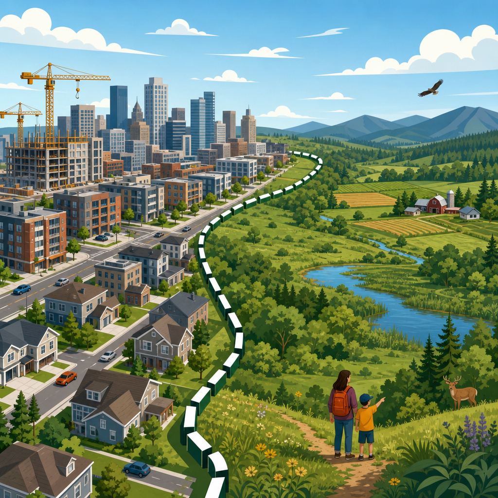
Urban growth boundaries are policy lines drawn around a city or metropolitan area to separate land intended for urban development from land intended to remain rural, agricultural, or environmentally protected. In practice, a boundary determines where housing subdivisions, commercial centers, industrial parks, roads, sewer extensions, and other urban services are encouraged, delayed, or restricted. The idea sounds simple, but the outcomes are not. After working with land use plans, zoning maps, and long-range infrastructure programs, I have seen how a boundary can shape not only the edge of a city but also land prices, commuting patterns, fiscal choices, and political conflict. Understanding what urban growth boundaries achieve and what they do not is essential for anyone studying urban planning and policy.
A clear definition helps. A growth boundary is not the same as a greenbelt, although the two are often related. A greenbelt is usually a permanently protected ring or network of open land. A growth boundary, by contrast, is a planning and management tool that can move over time through periodic review. It is also not identical to zoning. Zoning regulates use, density, height, setbacks, and form parcel by parcel, while a boundary establishes a strategic urbanization limit that guides where urban zoning and infrastructure will be extended. In many systems, the boundary works alongside a comprehensive plan, capital improvement program, farmland preservation rules, transportation modeling, and housing policy.
This topic matters because urban expansion has lasting consequences. Low-density outward growth can consume farmland, increase vehicle miles traveled, raise the cost of water and sewer networks, and fragment habitat. At the same time, limiting outward growth can increase pressure on land values inside the line, intensify neighborhood debates over redevelopment, and expose weaknesses in a city’s housing supply strategy. In other words, a boundary is neither a cure-all nor a symbolic line on a map. It is a governance choice with measurable effects. The best way to assess it is to separate direct achievements from goals that require additional tools.
What an urban growth boundary is designed to do
The primary purpose of an urban growth boundary is to coordinate land development with infrastructure and public services. When a city knows where growth is expected over the next twenty or thirty years, it can stage sewer mains, water lines, schools, transit investments, and emergency response facilities more efficiently. This sequencing matters. Extending utilities to scattered fringe developments is typically more expensive per household than serving contiguous areas because pipe lengths are longer, road maintenance obligations expand, and service districts become less compact. The boundary reduces leapfrog development by signaling that urban-scale services will be prioritized inside the planned growth area.
A second core objective is land conservation. Counties and metropolitan regions use growth boundaries to protect high-value agricultural soils, working forests, watersheds, floodplains, scenic landscapes, and wildlife corridors from piecemeal urbanization. Once rural land is fragmented by roads and subdivisions, restoring productive agricultural blocks or ecological connectivity becomes difficult and expensive. A boundary creates a stronger presumption that rural land remains rural unless a formal planning review justifies change. This is why boundaries are often paired with exclusive farm use zones, conservation easements, transfer of development rights programs, or habitat overlays.
A third objective is urban form. By channeling new development inward, a boundary can support infill, brownfield redevelopment, adaptive reuse, and more compact neighborhood patterns. That does not automatically mean high-rise construction everywhere. In many markets, it means townhouses on underused lots, apartment buildings along transit corridors, mixed-use redevelopment of aging shopping centers, and employment growth near existing arterial streets or rail stations. These patterns can improve the feasibility of frequent transit and active transportation because origins and destinations are closer together.
What urban growth boundaries actually achieve when they work well
Well-managed boundaries achieve predictability. Developers, utility agencies, farmers, and residents gain a clearer picture of where urban expansion is expected and where long-term rural protection is intended. Predictability lowers some forms of speculation and helps public agencies align budgets with adopted plans. In regions that review their boundary through a formal urban growth management process, planners can compare population forecasts, housing land supply, employment land needs, infrastructure capacity, and environmental constraints before expansion occurs. That is a materially better process than allowing scattered annexations to accumulate without a regional logic.
They also help limit infrastructure inefficiency. I have reviewed capital plans where a single fringe subdivision required oversized trunk lines, new lift stations, road widening, and school bus rerouting for relatively few homes. Those costs rarely disappear; they are distributed across ratepayers, taxpayers, and future maintenance budgets. A growth boundary can reduce those public liabilities by concentrating development where network capacity already exists or can be expanded in a contiguous pattern. Research from planning agencies and state growth management programs consistently shows that compact development can reduce per capita infrastructure costs compared with dispersed expansion, although savings vary by terrain, utility condition, and local service standards.
Another real achievement is farmland retention at the metropolitan edge. Oregon provides the most cited example because its statewide land use system requires every city to have an urban growth boundary. The Portland region has preserved large areas of surrounding farm and forest land that would have faced far more subdivision pressure under a purely market-led edge expansion model. Similar principles appear in places such as London’s greenbelt framework, although that system operates differently and is more permanent. The important point is that boundaries can slow conversion pressure enough to keep agricultural economies viable near urban markets.
| Policy goal | What a boundary can do | What it cannot do alone |
|---|---|---|
| Contain sprawl | Direct most urban services and rezonings inward | Guarantee compact design on every site |
| Protect rural land | Reduce pressure for subdivision outside the line | Ensure permanent conservation without added protections |
| Lower infrastructure costs | Improve service efficiency through contiguous growth | Eliminate expensive upgrades in older urban areas |
| Improve housing outcomes | Create incentives for infill and redevelopment | Deliver affordability without zoning and subsidy reform |
| Cut driving and emissions | Support shorter trips and better transit viability | Change travel behavior without transport investment |
What urban growth boundaries do not achieve on their own
The most common misunderstanding is that a boundary by itself makes housing affordable or unaffordable. The reality is more conditional. If a city limits outward growth but keeps large areas of single-family-only zoning, low floor-area ratios, excessive parking minimums, cumbersome approval processes, and neighborhood veto points, land prices inside the boundary can rise while homes remain undersupplied. In that case, the problem is not simply the boundary; it is the mismatch between growth containment and development capacity. A serious housing strategy requires upzoning in appropriate locations, faster permitting, public investment in infrastructure, inclusionary tools where feasible, and subsidies for below-market housing.
Boundaries also do not guarantee environmental sustainability. If a metropolitan area contains growth within a line but still builds auto-oriented subdivisions with wide roads, separated uses, and poor transit access, residents may continue to drive long distances for daily needs. Vehicle emissions depend on urban design, transportation options, and building performance, not only on where the city stops growing. Likewise, preserving rural land at the edge does not automatically protect all ecological systems if stormwater practices are weak or infill redevelopment displaces industrial contamination without remediation.
Another limit is equity. Growth boundaries can help reduce long-term fiscal waste, but they can also intensify competition for well-located land. Without anti-displacement measures, redevelopment pressure may fall heavily on lower-income renters and historically marginalized communities. I have seen plans celebrate compact growth while ignoring rent burdens, speculative acquisition, and the loss of small businesses. A fair approach includes tenant protections, community land trusts, affordable housing requirements calibrated to market conditions, preservation of naturally occurring affordable housing, and meaningful engagement before major rezoning decisions are made.
How housing markets interact with growth boundaries
Housing is the issue that most often decides whether the public views a boundary as successful. The key analytical question is not whether land is constrained, because all land markets are constrained by geography, ownership, infrastructure, regulation, and finance. The real question is whether the city has enough feasible development capacity inside the boundary to meet projected demand across income levels. Feasible capacity is different from theoretical capacity. A parcel may allow apartments on paper, yet be unlikely to redevelop because of lot size, assembly challenges, contamination, demolition cost, or weak rents.
Portland illustrates both the strengths and tensions of this model. Its regional boundary has supported a more compact urban form than many peer metros, but housing affordability pressures have still been significant, especially during periods of strong job growth and limited housing production. The lesson practitioners took was not that containment failed in principle. The lesson was that growth management must be paired with regular housing needs analysis, expansion when justified, and substantial internal capacity through middle housing, corridor intensification, and multifamily zoning near services. Cities such as Vancouver, BC, and parts of California face similar dynamics: containment policies influence supply conditions, but broader housing regulation and construction cycles often matter more.
For policymakers, the practical standard is straightforward. If the boundary is tight, internal zoning must be flexible enough to allow a wide range of housing types: accessory dwelling units, duplexes, triplexes, courtyard apartments, stacked flats, mid-rise buildings on transit streets, and mixed-use redevelopment in commercial areas. If those options are blocked, prices rise and households are pushed farther away into exurban jurisdictions beyond the region’s coordinated planning framework.
Governance, review cycles, and implementation challenges
The technical design of a growth boundary matters as much as the concept itself. Effective systems use population and employment forecasts, land capacity analysis, environmental constraints mapping, infrastructure finance plans, and transparent review criteria. They also define when the boundary can expand. Some regions require a documented twenty-year land supply; others use shorter staging horizons. The standard should be explicit, because discretionary expansions driven by short-term politics undermine credibility. At the same time, a boundary that is never reviewed can become detached from demographic reality.
Implementation often breaks down in three places. First, local jurisdictions may adopt a regional boundary while continuing exclusionary zoning inside it. Second, infrastructure agencies may not align capital investments with the land use plan, creating bottlenecks in areas intended for growth. Third, neighboring municipalities may compete for tax base and approve retail or industrial projects without coordinating transportation and housing impacts. Strong metropolitan governance, or at least binding intergovernmental agreements, is usually necessary to make the policy work.
Data quality is another challenge. Forecasts can be wrong, and housing market conditions can change quickly with interest rates, migration shifts, or construction costs. That is why good boundary management uses scenario planning rather than a single deterministic forecast. It also monitors building permits, vacancy rates, redevelopment trends, absorption of employment land, and infrastructure utilization. A line on a map should be treated as part of an adaptive planning system, not a static doctrine.
How to judge whether a boundary is succeeding
A useful evaluation framework asks five direct questions. Is rural land conversion slowing outside the urban edge? Is enough housing being permitted inside the boundary to meet demand? Are public service and infrastructure costs more efficient than they would be under dispersed growth? Are residents gaining better access to jobs, schools, parks, and transit through compact development? And are the benefits and burdens being shared fairly across communities? If the answer is no on several of these questions, the solution is rarely to abolish the boundary outright. More often, the answer is to reform the policies around it.
Metrics should include housing completions by type, redevelopment rates, farmland acreage preserved, sewer and road cost per added household, average commute distance, transit ridership, and displacement indicators such as eviction filings or rent increases in rezoned areas. These measures reveal whether the boundary is guiding growth constructively or merely deferring problems. In my experience, the strongest plans publish these indicators regularly and adjust land supply, zoning, and capital budgets before shortages become political crises.
Urban growth boundaries are most effective when treated as one instrument in a larger planning toolkit. They can curb sprawl, protect rural land, and improve infrastructure sequencing. They cannot, by themselves, solve housing affordability, guarantee sustainability, or deliver equity. Those outcomes depend on what happens inside the line: zoning reform, transit investment, public finance, environmental regulation, and community safeguards. That is the central lesson for urban planning and policy. If you are building out this subtopic, use this hub as the starting point, then examine housing capacity, transit-oriented development, farmland preservation, and regional governance in greater detail.
Frequently Asked Questions
What is an urban growth boundary, and what is it actually designed to do?
An urban growth boundary, often called a UGB, is a policy line drawn around a city or metropolitan area to distinguish land planned for urban development from land intended to remain rural, agricultural, or environmentally protected. Inside the boundary, local governments generally plan for housing, shopping areas, employment centers, roads, utilities, schools, and other urban services. Outside the boundary, development is typically limited, delayed, or shaped by stricter rural land use rules. The core purpose is not simply to stop growth. It is to manage where growth goes, when infrastructure is extended, and how efficiently land and public investment are used.
In practice, a UGB is meant to support more orderly development patterns. Instead of allowing subdivisions, commercial strips, and industrial projects to spread outward in a scattered way, the boundary encourages growth to occur in places where roads, sewer, water, transit, and emergency services can be provided more efficiently. That can help reduce leapfrog development, protect farmland and open space, and make it easier for communities to align land use decisions with long-term public budgets. A well-run boundary can also help local governments phase growth so that infrastructure expansion follows a plan rather than reacting to piecemeal development pressure.
What a UGB is not designed to do is equally important. It does not automatically create affordability, guarantee compact walkable neighborhoods, eliminate traffic, or preserve every acre of rural land outside the line forever. Those outcomes depend heavily on zoning, housing policy, transportation investment, political enforcement, and whether the boundary is adjusted over time. In short, an urban growth boundary is a growth management tool, not a stand-alone solution. Its achievements and limitations both come from how it is implemented alongside the rest of the planning system.
Do urban growth boundaries make housing more expensive?
They can contribute to higher land prices in some situations, but the relationship is not simple or automatic. A boundary can increase the value of developable land inside the line because that land becomes more clearly positioned for urban use, especially if demand for housing is strong and the amount of land zoned for new homes is limited. At the same time, land outside the boundary may see lower speculative pressure for suburban development because it is less likely to receive urban services. The real question is not whether a line exists on a map, but whether enough housing capacity exists inside that line to accommodate growth.
If a metropolitan area has a UGB but maintains restrictive zoning inside it, such as large-lot single-family requirements, low height limits, burdensome approvals, or resistance to infill and redevelopment, housing shortages can intensify. In that scenario, the boundary may get blamed for price increases that are actually driven by constrained housing production within the urbanized area. On the other hand, if a city allows a healthy mix of housing types, including apartments, townhomes, accessory dwelling units, and redevelopment near transit and job centers, a boundary can function without producing the same degree of price pressure. The supply of buildable and legally developable housing matters as much as the amount of raw land.
It is also important to separate land cost from total housing cost. Even when land values rise inside a boundary, efficient infrastructure provision, shorter utility extensions, and more compact development can reduce certain public and private costs over time. Still, there is no honest way to say a UGB has no effect on price dynamics. In hot markets, it can tighten competition for urban land unless local governments expand capacity through zoning reform and regular planning updates. So the best answer is that urban growth boundaries do not inherently make housing unaffordable, but they can worsen affordability problems when paired with weak housing supply policies.
How do urban growth boundaries help protect farmland, open space, and environmentally sensitive land?
One of the clearest achievements of urban growth boundaries is that they create a stronger planning distinction between urban and rural land. That distinction matters because farmland, forests, wetlands, habitat areas, and scenic landscapes are often lost incrementally, one subdivision, road extension, or utility extension at a time. By signaling that certain areas are not intended for near-term urbanization, a boundary can reduce speculative conversion pressure and make it easier for agricultural and conservation uses to continue. For farmers, predictability can be valuable because it lowers the risk that surrounding land will rapidly fragment into incompatible suburban uses.
Boundaries also help by controlling the public investments that often drive outward development. When sewer lines, major roads, and other urban services are extended into rural areas, development typically follows. A UGB gives local governments a policy basis to withhold or phase those extensions, which is often more effective than simply stating a preference for preservation. In other words, the boundary is not just symbolic. It can influence capital planning, service delivery, annexation policy, and entitlement decisions in ways that materially shape whether rural land remains rural.
That said, a UGB does not guarantee perfect preservation outcomes. Land outside the boundary can still be affected by estate lots, rural subdivisions, infrastructure corridors, or political pressure to amend the line. Environmental protection also depends on underlying conservation rules, agricultural zoning, watershed regulations, and enforcement. Some areas need stronger tools than a boundary alone, especially where ecological resources are fragile or where market pressure is intense. So while urban growth boundaries can be very effective at reducing broad patterns of sprawl and preserving large landscapes, they work best as part of a larger framework of rural protection and environmental stewardship.
Can an urban growth boundary reduce traffic, sprawl, and infrastructure costs?
It can help, but only under the right conditions. Urban growth boundaries are often promoted as anti-sprawl tools because they encourage development to occur in a more contiguous and serviceable pattern rather than in scattered, low-density expansion at the metropolitan edge. More compact growth can reduce the need for long road extensions, dispersed sewer networks, and other costly infrastructure built far from existing urban areas. From a public finance perspective, this can mean better use of tax dollars because local governments are serving growth in places where systems already exist or can be expanded more efficiently.
On transportation, the effects are mixed and highly dependent on urban design. If a UGB supports infill, mixed-use development, stronger transit corridors, and neighborhoods where daily needs are closer together, then some vehicle travel may be reduced and more trips may shift to walking, biking, or transit. But if the area inside the boundary still develops in an auto-oriented way, with separated land uses, wide arterial roads, and low-density subdivisions, then traffic problems may persist even without outward sprawl. A boundary by itself does not redesign streets, improve transit service, or create complete neighborhoods. It changes the geography of growth, not the entire travel behavior of a region.
As for infrastructure costs, the broad planning logic behind UGBs is strong: compact service areas are generally cheaper to serve than spread-out ones. However, there can be tradeoffs. Intensifying already urbanized areas may require expensive upgrades to aging water, sewer, stormwater, or transportation systems. Redevelopment can also involve land assembly, environmental cleanup, and public investment in parks or schools. So the claim should not be that urban growth boundaries always lower every cost. A more accurate claim is that they can improve long-term infrastructure efficiency and reduce the fiscal burden of unmanaged outward expansion, especially when paired with good capital planning and sensible urban zoning.
What are the biggest limits of urban growth boundaries, and what do they not solve on their own?
The biggest limitation is that a boundary is only one piece of a much larger land use system. It can shape where growth is directed, but it does not by itself determine what gets built, how fast it gets approved, how affordable it will be, or whether neighborhoods become more livable. Those outcomes depend on zoning rules, housing production, redevelopment capacity, transportation planning, utility investment, environmental regulation, and local political willingness to allow change. If the rules inside the boundary are too restrictive, growth pressure does not disappear. It simply gets redirected into competition for a limited number of sites, longer commutes from farther jurisdictions, or repeated fights over plan amendments.
Another limitation is flexibility. A boundary that is too rigid can fail to adapt to population growth, changing economic conditions, or infrastructure realities. A boundary that is too easily expanded, on the other hand, may lose much of its purpose. Successful systems usually rely on periodic review, land supply analysis, and clear criteria for adjustments rather than ad hoc political exceptions. The challenge is maintaining enough certainty to guide investment while allowing enough responsiveness to avoid artificial shortages or distorted development patterns.
Urban growth boundaries also do not solve regional inequality, displacement, or weak transit performance on their own. A city can have a UGB and still produce exclusionary housing patterns, underinvest in lower-income neighborhoods, or fail to coordinate jobs and housing. Likewise, a boundary does not guarantee better design quality, climate resilience, or ecological restoration inside the urbanized area. It is a policy tool with real value, but it has to be supported by implementation. The most realistic view is that urban growth boundaries can be effective at organizing growth and limiting outward sprawl, but they are not a substitute for comprehensive housing, transportation, environmental, and fiscal policy.


